Luggate Red Bridge in Queenstown-Lakes District, New Zealand

Sight · Queenstown-Lakes District, New Zealand

Luggate Red Bridge

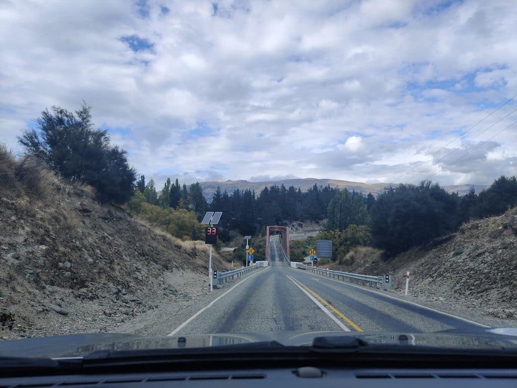
Historic red truss bridge over the Clutha, easy photo stop

Photo: Mapillary
Type
Sight
Audio stories
2 nearby
  • Parking
  • Restrooms
  • Scenic viewpoint

Hear the audio tour

The Historic Luggate Red Bridge

Overview

About Luggate Red Bridge

This handsome heritage span—also known as the Grandview Bridge—crosses the Clutha/Mata‑Au between Wānaka and Cromwell on State Highway 6. It’s an easy, anytime stop for a quick photo or a leg stretch, with open river views and a broad gravel reserve beside it for day use and overnighting.

Why stop

  • Photogenic 1915 steel truss over the Clutha/Mata‑Au
  • Easy roadside stop on SH6 with river access and nearby reserve

Heads up

  • Road noise and evening crowding at the reserve
  • Basic facilities only—long‑drop toilets, no running water
Opened on October 28, 1915, the bridge is listed on the Queenstown Lakes District Council’s Historic Register and is celebrated for its elegant proportions. It runs 103.7 m with a 61 m Baltimore through‑truss, a 30.5 m truss, and a 12.2 m rolled steel joist end span—classic engineering that still looks great in photos.
Parkwolf’s verdictWhy it’s special

Map

Where it is

Loading the Queenstown-Lakes District map
Full map
SightLuggate Red Bridge-44.73071, 169.28179
Keep this map with you offline in the Parkwolf app

Local know-how

Tips for visiting Luggate Red Bridge

  1. Overnighters must arrive after 5 pm and depart before 10 am.

  2. Certified self‑contained vehicles only; tents are not permitted at the reserve.

  3. Bring water and hand sanitiser—only long‑drop toilets are provided.

  4. Expect evening crowding in peak season; aim to secure a space early.

  5. Keep well clear of the Clutha/Mata‑Au’s strong current and passing jet boats.

Plan your stop

Before you go

Best time to visit

The bridge is accessible 24 hours. Early mornings tend to be the quietest for photos and a quick stroll; mid‑day and weekend evenings are busier, and the camping area often fills most nights in peak season.
Camping & facilities at Red Bridge Reserve

This is a freedom‑camping site for certified self‑contained vehicles only. Expect a large gravel area, two long‑drop toilets, and no running water, power, or dump station. It’s popular: evenings often fill, surfaces can be uneven, and there’s some road noise. Recent council settings allow up to 50 marked spaces with these rules:

  • Arrive after 5:00 pm, depart before 10:00 am.
  • Maximum 3 nights in any 30‑day period.
  • No tents or structures; no fires; keep within your marked space.
A park ranger sits on a dash-mounted phone, talking, as Parkwolf’s Tour Guide plays “Army Cutworm Moths: A Grizzly Bear Buffet” on Grand Loop Road below Dunraven Pass in Yellowstone
Parkwolf Tour GuideThe highest, rockiest slopes around here are a summer buffet for grizzly bears.

Queenstown-Lakes District Tour Guide

Your drive to Luggate Red Bridge, narrated.

Parkwolf is a GPS audio tour guide for Queenstown-Lakes District, New Zealand. As you drive, it chimes in with what’s ahead: hidden gems, upcoming stops, history, geology, and wildlife, right through your car’s speakers.

See the Queenstown-Lakes District audio tour

Recorded for this place

The Historic Luggate Red Bridge
Listen
“The striking red bridge coming into view is the historic Luggate Red Bridge, which opened back in 1915.”

Plays as you drive up to Luggate Red Bridge in the Parkwolf Queenstown-Lakes District Tour Guide.

More stories near here in the app

  • Warbirds Over Wānaka
  • Why the Hills Have Stripes: Sheep Terracettes
  • The Cardrona: A Vanishing River
  • 164 audio storiesacross Queenstown-Lakes District’s roads, triggered by GPS as you drive
  • Wildlife heatmapsfor Kea, Kākā, Kererū, and 13 more
  • Works offlinemaps, 37 trails, 111 places, and audio download before you lose signal
  • CarPlay readysimple controls built for the drive
★★★★★
“Fantastic app with many points of information… It’s great to just turn on while you’re driving and it gives you an audio tour of the national Park. We love it!!!!”
JMJamesApp Store review
Download Parkwolf on the App StoreGet Parkwolf on Google Play

4.7 from 8,600+ ratings

Guide

More about Luggate Red Bridge

What you’ll see & doSnap the rusty‑red truss against the emerald river and surrounding willows.
  • Snap the rusty‑red truss against the emerald river and surrounding willows.
  • Wander the reserve down to the water’s edge (the current is strong—keep clear for safety). Visitors also note occasional jet‑boat traffic passing below.
  • Play a quick round on the adjacent 9‑hole disc golf course (free, dogs allowed; dirt tees; typical round 30–60 minutes).
Tips for a smoother stopBring your own water and hand sanitiser—services are minimal.
  • Bring your own water and hand sanitiser—services are minimal.
  • If you plan to overnight in peak season, arrive early in the evening to secure a spot.
  • For more picnic comforts, the nearby Luggate township has additional public toilets.

Wildlife

Wildlife in Queenstown-Lakes District

All Queenstown-Lakes District wildlife maps

Sighting maps show where each species has been reported across Queenstown-Lakes District. Wildlife moves, so no sighting is guaranteed.

Parkwolf’s Queenstown-Lakes District ranking

Top sights in Queenstown-Lakes District

All 111 places
  1. 1Lake WakatipuSight
  2. 2Ben LomondSight
  3. 3Bob’s Peak – Queenstown Gondola LookoutSight
  4. 4Lake WānakaSight
  5. 5TSS EarnslawSight
  6. 6Ben Lomond SaddleSight

Take Parkwolf to Queenstown-Lakes District.

The audio tour guide for the drive, plus offline maps, trails, and wildlife heatmaps for when the signal drops.
4.7 from 8,600+ ratings

Download Parkwolf on the App StoreGet Parkwolf on Google Play