
Place · 3.3 mi away
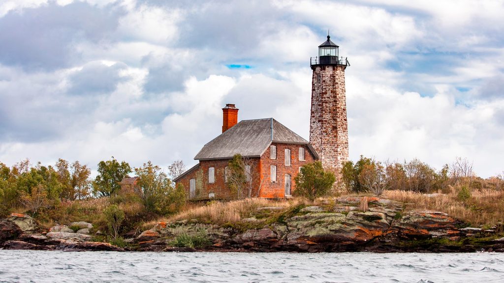
Also known as Menagerie Island Light, this 61‑foot, double‑walled, octagonal sandstone lighthouse sits on long, rocky Menagerie Island at the entrance to Siskiwit Bay. It’s a rugged, no-frills stop that feels far from everything—perfect if you love historic Great Lakes architecture without the crowds.
Expect a stout sandstone tower capped by a black lantern and gallery, plus an attached keeper’s house linked by a short covered passage. The island is stark and treeless with waves crashing around you—great for moody photos and big lake vistas. The grounds can be viewed if you land, but the tower itself is closed.
There’s no public ferry or tour landing here; it’s private‑boat access only. Navigating in requires care—surrounding shoals and rocks are part of why the light was built in the first place. There are no services of any kind (no water, restrooms, or shelter), and the site is fully exposed to Lake Superior’s famously changeable conditions. Plan to be completely self‑sufficient.
Placed in service in 1875 with a fourth‑order Fresnel lens, the station was automated early (1913) and later modernized to a solar‑powered optic. Its robust stone construction and storm‑ready details speak to the realities of this shoreline. The light station is recognized on the National Register of Historic Places (1983).
The sources don’t document specific wildlife at this site. The draw here is the austere setting and the lighthouse itself.
There aren’t practical “hours” for a place like this; it’s effectively always open, but access is entirely weather and boat‑dependent. It rarely feels busy because of the private‑boat requirement. Pick a fair‑weather daylight window for safer landings and better photos, and always check the forecast—Lake Superior can turn fast.
The lighthouse’s octagonal form, attached dwelling, and wave-battered rock make strong subjects from multiple angles along the landing area and shoreline. Expect harsh exposure and bring protection for gear if spray kicks up.
Place · 3.3 mi away
Place · 3.3 mi away
Place · 3.9 mi away
Place · 6.3 mi away
Challenging · 3.3 mi away
Moderate · 7 mi away
Moderate · 10 mi away
Easy · 10 mi away

Parkwolf Tour Guide
