
Place · 0 mi away
Challenging

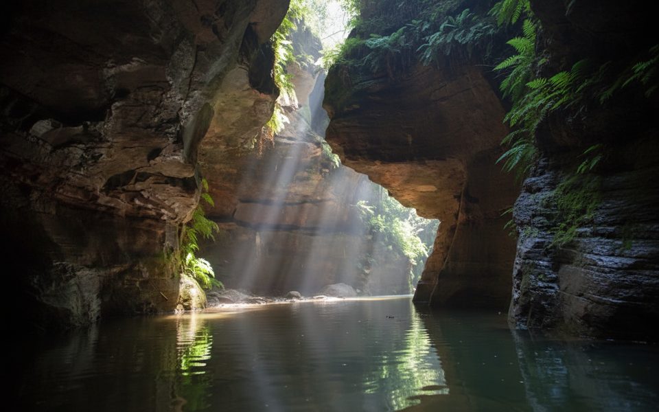
Claustral Canyon is a legendary, technical slot canyon—more committing canyon adventure than walking track. Expect three big abseils straight down waterfalls to enter via the famous “Black Hole of Calcutta,” then a long, wild journey through a fern-draped sandstone cathedral with cold pools, swims, and slick boulders. It’s remote, serious, and stunning.
Plan for roughly 12 km total (about 7.5 miles) including the approach, the canyon itself, and the long exit. Most parties take 8–12 hours depending on experience, group size, and efficiency at the abseils and swims. The exit is steep and feels longer than the numbers suggest.
Inside the canyon, towering Triassic sandstone walls pinch to narrow slots where shafts of light filter down onto lush ferns and moss—classic “natural cathedral” scenes. You’ll negotiate multiple mandatory swims (including a notable ~50 m tunnel swim), cascades, down-climbs, and the three defining waterfall abseils at the entry. In darker sections, glow worms add a surreal sparkle.
This route is for experienced canyoners only. You need solid abseil skills, strong swimming, cold-water tolerance, and confident scrambling/route-finding. Wetsuits, harnesses, helmets, and full abseil kits are essential; waterproof your pack for repeated immersions. Hazards include cold water and hypothermia, slippery rock, committing swims, and flash flooding. The exit gully is notoriously easy to miss, and sections feel like low-grade, unprotected climbing—study the exit in advance and carry maps.
Summer (December–February) is the season here; the water is still cold, but tolerable compared to cooler months when hypothermia risk spikes. Start at dawn to bank daylight for the exit. Avoid recent or forecast heavy rain. Weekdays are even quieter, though this canyon sees relatively few parties year-round.
Access is from a large pull-off on Bells Line of Road just southwest of Mount Bell. A formed track heads southeast, descending to Claustral Brook via a gully before the technical entry. The standard exit climbs out via Rainbow Ravine/Camels Hump to the road; depending on where you parked, expect a short roadside walk back to the car.
Pets are not permitted. A free canyoning booking/ePass is required on weekends and public holidays from early October to late April. Group-size limits and seasonal conditions apply. Rescue here is difficult—go with competent partners or a guided group if it’s your first time.
Unmarked pull-off on Bells Line of Road southwest of Mount Bell; start on the formed track heading southeast toward Claustral Brook. Exit returns to the road with a short roadside walk back to your car.
Technical canyon: three mandatory waterfall abseils (Black Hole of Calcutta), multiple cold swims including a ~50 m tunnel swim, slippery rock, and a tricky exit gully. Flash-flood and hypothermia risks are real. Go only with experienced canyoners, full equipment, and a pre-planned exit; book required on many warm-season weekends/holidays.
Place · 0 mi away
Place · 1.5 mi away
Place · 2.8 mi away
Place · 2.9 mi away
Challenging · 2.8 mi away
Challenging · 3.8 mi away
Easy · 3.8 mi away
Challenging · 3.8 mi away

Parkwolf Tour Guide
