Pros & cons
PROS
- Remarkable early-1900s engineering relic with sweeping mountain views
- True backcountry adventure for history and off‑road enthusiasts
- National Register–listed site with surviving wooden tram towers
CONS
- Extremely remote; rugged 4x4 approach or strenuous hiking required
- No amenities or on-site interpretation; structures are fragile
- Only a few towers are inside the park; most of the line is outside
Overview
If you like your history wild and remote, this one’s for you. Built 1911–1913, the Saline Valley Salt Tram hauled salt across the Inyo Mountains with an electric aerial tramway stretching roughly 13–13.4 miles and climbing more than 7,000 vertical feet with grades up to 40 degrees—the kind of audacity that put it on the National Register of Historic Places. Only the first four towers sit inside the park; most of the line continues onto public lands beyond the boundary.
What You’ll See
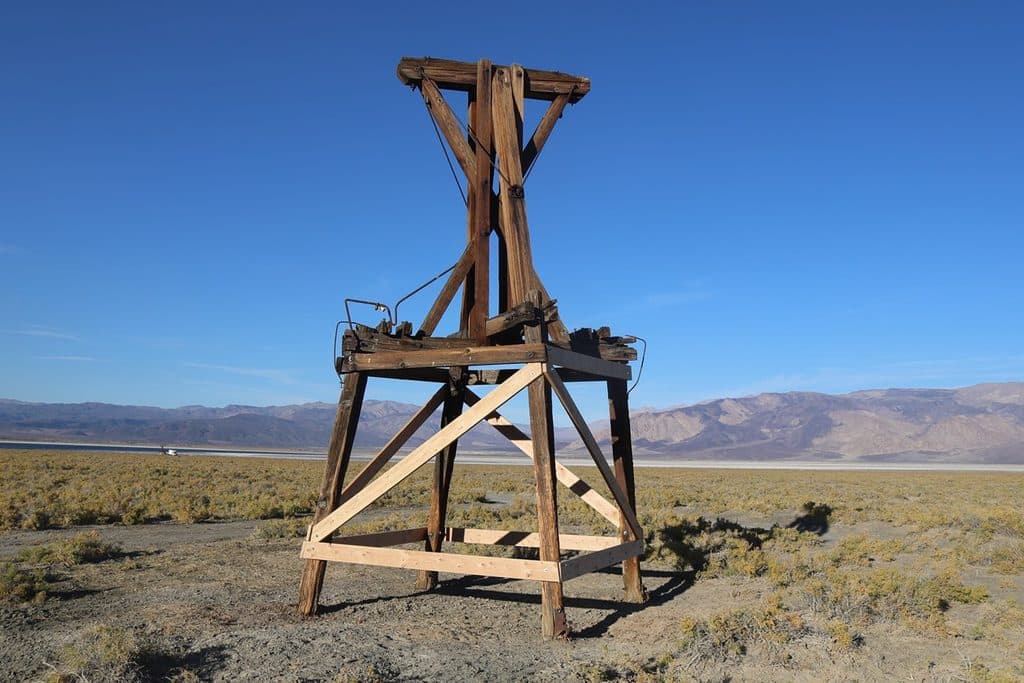
Expect weathered wooden tram towers, remnants of stations and cable works, and massive timbers preserved by the desert’s dry air. The scenery is half the show: big, open views over Saline Valley, the Inyos, and toward Owens Valley. You may come across scattered historic artifacts—look, photograph, leave them in place.
Access & Experience
This is backcountry. Reaching the structures typically involves rugged, high-clearance 4WD routes and/or hiking. There’s no formal trailhead, no signage, and no services. Road conditions can shift with weather; plan like it’s a wilderness trip and build in extra time. The sense of isolation and the scale of the undertaking are what make the visit memorable.
Why It’s Unique
Few early 20th‑century industrial projects matched this combination of length, relief, and steepness. Standing beneath the towers, the engineering leaps off the page—an improbable line strung over a serious mountain barrier to move salt from Saline Valley to markets in Owens Valley.
History in a Nutshell
Salt extraction in Saline Valley dates back to the 19th century. The tramway was completed in 1911, saw sporadic use under several companies, and finally shut down in the 1930s. The remains endure as a rare industrial landscape in a spectacular setting.
Wildlife
This high, arid country can feel empty, but the broader area supports desert bighorn sheep, raptors, reptiles, and small mammals. Sightings are hit‑or‑miss given the elevation, dryness, and remoteness—treat any encounter as a bonus.
Best Time to Visit
There are no hours or gates here, but you’ll get the most out of the site in the cooler parts of the day with low‑angle light—early morning or late afternoon—when the towers and ridgelines photograph best. Always check current road and weather conditions before committing to the drive.

Safety & Stewardship
These historic structures are fragile and can be unstable—admire without climbing or disturbing anything. There’s no water, fuel, or cell service. Come self‑reliant and practice Leave No Trace. Remember: only a handful of towers are within the park; the rest lie on adjacent public lands with their own rules.
Where it is
36.6077, -117.8539Tips for Saline Valley Salt Tram Historic Structure
- 01Bring detailed maps and a GPS; routes are rugged and not obvious.
- 02Start with a full tank and carry plenty of water and emergency supplies.
- 03Do not climb on towers or remove artifacts; the site is fragile.
- 04Check road and weather conditions before you go; plans change fast here.
- 05Know that only the first few towers are in the park; respect boundaries.
Near Saline Valley Salt Tram Historic Structure
All places →All trails →
14.4 mi awayLower Warm SpringsRemote Saline Valley hot springs with primitive campingRestroom · Parking
15 mi awayVolcano PoolLargest Saline Valley soak with palm-fringed desert oasis vibesRestroom · Parking
15 mi awaySaline Valley Warm SpringsRemote, clothing-optional desert oasis with volunteer-kept soaking tubsRestroom · Parking
16.7 mi awayUpper Warm SpringUndeveloped desert hot spring for solitude seekers
17 mi awayRacetrack PlayaRemote, surreal walk to The Grandstand and sailing stonesEasy · 1.5 mi · 1.5 hr
27 mi awayDarwin Falls TrailA shady, year-round desert oasis with a real waterfall.Easy · 2 mi · 1.3 hr
30 mi awayMarble CanyonRemote marble narrows, petroglyphs, and big desert silence.Moderate · 8 mi · 5 hr
31 mi awayCottonwood-Marble Canyon LoopRemote desert loop linking Cottonwood, Deadhorse, and Marble CanyonsChallenging · 26 mi · 18 hr