Badwater Basin

Vast salt flats at the continent’s lowest point
Badwater Basin, Death Valley National Park
InsideDeath Valley National Park

Overview

Badwater Basin is the park’s headliner: a vast, blinding-white salt flat sitting 282 feet below sea level. Step off the short boardwalk and you’re on an ancient lakebed where bright salt crust stretches to distant mountains, including Telescope Peak rising over two miles above you. It’s surreal and absolutely worth your time.

What You’ll See

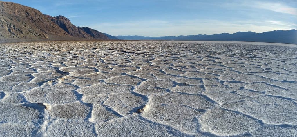
  • Salt polygons: geometric, hexagon-like patterns etched into the crust. The best, crispest polygons are a short, easy walk out onto the flats rather than right by the parking area.
  • A small spring-fed pool at the boardwalk’s edge—this is the namesake “bad water,” rimmed in salt and undrinkable.
  • Big views: look west to the Panamint Range and up to the cliff behind the lot for a sea-level sign that really drives home how far below sea level you are.

On-the-Ground Experience

From the parking area, a short paved approach and wooden boardwalk lead you onto hard-packed salt. The surface near the start is firm and easy-going; for the most photogenic polygons, plan on walking about 1.5–2 miles roundtrip. After rare rains, parts of the basin can hold shallow water and the surface may be soft under a thin crust—beautiful, but take care.

Best Time to Visit

Go early morning or late afternoon for cooler temps and flattering light; the midday sun can be punishing and the salt amplifies the glare. Sunset often adds color to the surrounding ranges and can reflect in any lingering water on the flats. It’s a popular stop, so early and late hours also help with parking and elbow room.


Geology Snapshot

You’re standing on the floor of an endorheic basin—water that flows here has nowhere to go. Long ago this was Lake Manly; as climate shifted, the lake evaporated, leaving behind concentrated salts. As groundwater wicks upward and evaporates, the surface contracts and buckles into the polygon patterns you see. Periodic flooding and drying cycles subtly refresh and reshape them over time.

Need-to-Know

  • Heat is the real hazard here. There’s no shade, no drinking water, and services are a drive away—bring more water than you think you need and solid sun protection.
  • Restrooms are located at the parking area.
  • The crust can be thin in places, especially after rains. If it looks damp or fragile, don’t venture onto it—both for your safety and to avoid leaving footprints that scar the flats.

Pros

  • Iconic lowest point in North America
  • Striking salt‑polygon flats with big mountain views
  • Easy, flat walk from parking to the salt flats

Cons

  • Extreme heat and intense sun/glare off the salt
  • Often crowded; parking can fill at peak hours
  • No shade or on-site services

Tips

  • For the best salt polygons, walk about 1.5–2 miles roundtrip onto the flats.
  • Arrive at sunrise or near sunset for cooler temps, softer light, and fewer crowds.
  • Bring ample water, sun protection, and snacks—there are no services on site.
  • If the surface looks damp or soft, avoid it; the salt crust can be thin over mud.
  • Look up for the sea‑level sign and west to Telescope Peak to feel the relief difference.
The Parkwolf tour guide sitting on a phone mounted in a car

Parkwolf Tour Guide

Like a tour guide in your car.

Save the places you found around Death Valley, then let Parkwolf guide the drive between them.Download Parkwolf on the App Store