Pros & cons
PROS
- Spring-fed desert oasis with shade and an NPS interpretive sign
- Evocative mining-era ruins and cabins to explore along a classic 4x4 route
CONS
- High-clearance 4x4 required; roads are flood-prone and change often
- No services or facilities; buildings are unstable and hazardous inside
Overview
Warm Springs Camp is a remote, spring-fed oasis tucked in a backcountry canyon, where mining-era cabins and relics meet a rare ribbon of water and greenery. It’s the kind of place that feels improbable out here—quiet, shady, and layered with stories.
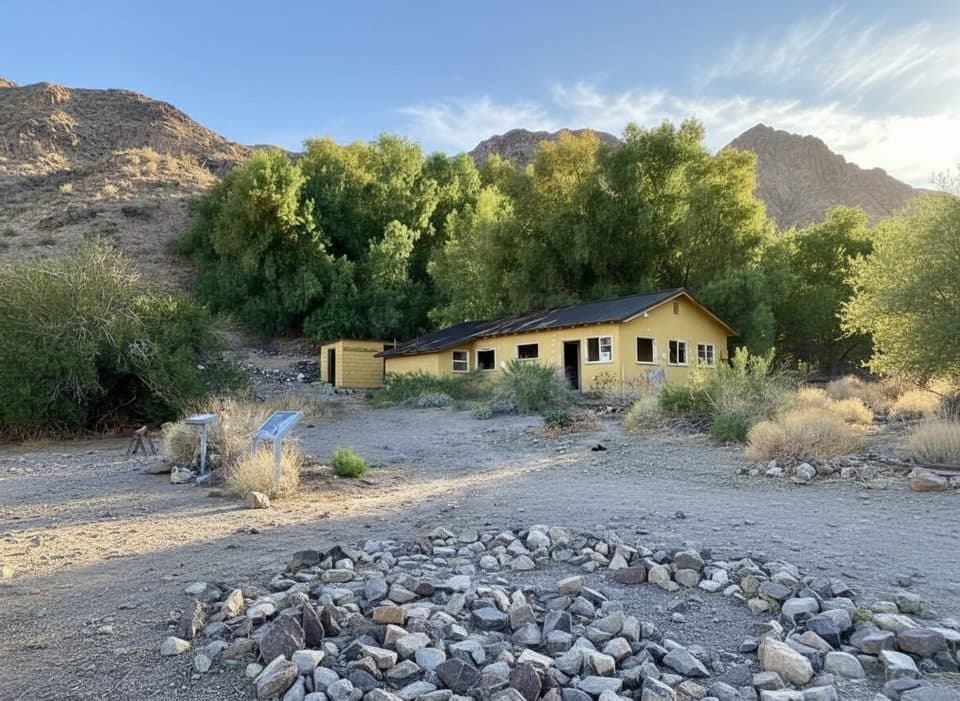
An NPS interpretive sign anchors the site, and travelers often call this one of the nicest stops on the Striped Butte/Butte Valley 4x4 route. Expect solitude, a handful of standing structures, and the gentle sound of water in an otherwise stark landscape.
What You’ll See
- 1930s-era buildings: a main house, bunkhouse, and utility structures, plus a gated mine shaft and ore-processing remnants.
- A concrete swimming pool from the camp’s heyday (not maintained and discouraged from being filled).
- Mining equipment scattered around the site and an NPS information sign (with a visitor guestbook noted by some reports).
History Snapshot
Warm Springs became a hub for talc and gold operations in the early 20th century. One figure looms large: Louise Grantham, a tenacious prospector who eventually ran the area’s most successful talc mine for decades. The spring itself has drawn people much longer—used historically as a winter camp by Indigenous groups—so you’re walking through layers of human history as well as industrial relics.
Getting There and Road Conditions
Access is via Warm Springs Canyon Road toward Butte Valley. It’s all dirt, with ruts and rocks, and it’s frequently reshaped by flash floods. A high-clearance 4x4 isn’t optional here. Check the park’s road-status updates before you commit. From the road, the mustard-colored building can look occupied; it’s part of the historic camp.
Camping and Vibe
This is not a developed campground—no reservations, hookups, or facilities. Travelers have used the cabins and area as a rustic overnight stop, but you should be fully self-sufficient and treat it as primitive camping only. Pack out everything.
Wildlife
Wild burros are commonly seen wandering through the area, drawn by the spring. Birds and small mammals also frequent the oasis.
Safety and Etiquette
- Do not enter the old buildings; they’re unstable and may contain hazards like asbestos, lead paint, or Hantavirus.
- Don’t divert spring water into the old pool—past incidents harmed wildlife and created unsanitary conditions.
- No services are available; bring all water, food, and emergency supplies.
Best Time to Visit
There are no set hours and crowds are typically low due to the 4x4 approach. The real gatekeeper here is road condition—plan your visit around recent weather and flood reports. The oasis and structures photograph well throughout the day; give yourself time to wander and explore.

Where it is
35.9680, -116.9315Tips for Warm Springs Camp
- 01Drive a high-clearance 4x4 and check the park’s road-status page before you go.
- 02Don’t be fooled if the main building looks occupied—it’s part of the historic camp.
- 03Do not enter structures; they’re unstable and may contain hazardous materials.
- 04Do not divert spring water to the old pool; it’s harmful to wildlife.
- 05Bring paper or GPS maps—cell service is unreliable and there are no services.
Amenities
Near Warm Springs Camp
All places →All trails →
8 mi awayStriped ButteBanded desert landmark in remote Butte Valley reached by true 4x4Scenic Viewpoint
9.1 mi awayGeologist's CabinBeloved stone cabin with Striped Butte views, deep in Butte ValleyParking · Scenic Viewpoint
11.4 mi awayMormon Point ViewQuiet roadside overlook of the Black Mountains and the salt panPullout · Scenic Viewpoint
12.4 mi awaySidewinder CanyonTwisty slot canyons with scrambles, solitude, and route-finding.Challenging · 5 mi · 4 hr
12.4 mi awayWillow Canyon TrailQuiet desert canyon to a rare seasonal waterfall and narrows.Moderate · 4.4 mi · 2.1 hr
13.8 mi awayPanamint CityRemote ghost town ruins reached by a strenuous canyon hike
20.3 mi awayBadwater Basin Salt FlatsWalk the otherworldly salt polygons at North America’s lowest pointEasy · 1.9 mi · 33 min
20.3 mi awayBadwater Basin BoardwalkEasy stroll to surreal salt flats at North America's low pointEasy · 1 mi · 45 min