Wildrose Campground in Death Valley National Park

Campground · Death Valley National Park

Wildrose Campground

Free, cooler high‑desert campground near top Panamint hikes

Photo: National Park Service
Type
Campground
Audio stories
1 nearby
  • Restrooms
  • Picnic tables
  • Parking

Hear the audio tour

Wildrose Campground: A Cooler Camping Spot

Overview

About Wildrose Campground

If you want Death Valley camping without the blast-furnace heat, Wildrose sits around 4,100 feet on the flank of the Panamints and feels like a different world—cooler, quieter, and dotted with desert hills instead of salt flats. It’s free, first‑come, and simple: water spigots, tables, fire rings, and vault toilets. The tradeoff is remoteness and minimal services, but the payoff is star‑studded skies and sunrise/sunset light on the ridgelines.

Why stop

  • Free, first‑come sites with potable water, picnic tables, and fire rings
  • Cooler high‑elevation setting with big views and dark‑sky stargazing
  • Great base for nearby hikes to Wildrose Peak, Telescope Peak, and the Charcoal Kilns

Heads up

  • No flush toilets or dump station; no hookups
  • Can be very windy with little natural shade
  • Remote with a long, curvy drive and often limited/no cell service

Map

Where it is

Loading the Death Valley map
Full map
CampgroundWildrose Campground36.26579, -117.18818
Keep this map with you offline in the Parkwolf app

Local know-how

Tips for visiting Wildrose Campground

  1. Arrive by early afternoon; the 23 free first‑come sites fill toward evening.

  2. Bring all food, water containers, and fuel—services are a long drive away.

  3. Stake and guy‑out tents; afternoon and nighttime winds can be fierce.

  4. Pack a wash basin and do dishes at your site, not at the spigots.

  5. Check current status and any advisories before you go at [nps.gov](https://www.nps.gov/deva/planyourvisit/wildrose-campground.htm).

Plan your stop

Before you go

Best time to visit

Spring and fall are the sweet spot for temps; winter can bring cold nights at this elevation. In summer, it’s often much cooler here than on the valley floor, which is a lifesaver. For snagging a site, arrive by early afternoon—these free spots get “coveted” toward evening. Photographers: sunrise and sunset paint the surrounding ridges beautifully, and nights are prime for astrophotography.

Campsites & Amenities

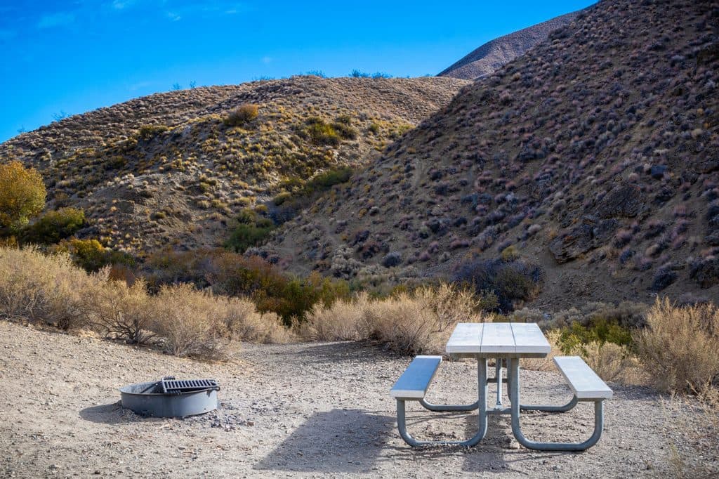
There are 23 first‑come sites spread along a hillside loop. Expect hard gravel pads, a picnic table, and a fire ring at each site. You’ll find potable water via spigots, and vault toilets serve the campground. There’s no dump station and no hookups, so plan accordingly.

3 active Death Valley alerts

  • ClosurePark roads closed or hazardousPlan around multiple closed roads and use extra caution on damaged routes. - Paved roads: North Highway and Beatty Cut-off are closed due to flooding and debris from the October 22 storm.Official details
  • ClosureSaline Valley Lower Springs closed after wildfireLower Springs at Saline Valley Warm Springs remains closed after the September 15 wildfire; stay out because the fire left safety hazards, including potential hazardous chemicals.Official details
See all 3 alerts
A park ranger sits on a dash-mounted phone, talking, as Parkwolf’s Tour Guide plays “Army Cutworm Moths: A Grizzly Bear Buffet” on Grand Loop Road below Dunraven Pass in Yellowstone
Parkwolf Tour GuideThe highest, rockiest slopes around here are a summer buffet for grizzly bears.

Death Valley Tour Guide

Your drive to Wildrose Campground, narrated.

Parkwolf is a GPS audio tour guide for Death Valley National Park. As you drive, it chimes in with what’s ahead: hidden gems, upcoming stops, history, geology, and wildlife, right through your car’s speakers.

See the Death Valley audio tour

Recorded for this place

Wildrose Campground: A Cooler Camping Spot
Listen
“You're now passing the turn for Wildrose Campground.”

Plays as you drive up to Wildrose Campground in the Parkwolf Death Valley Tour Guide.

More stories near here in the app

  • Pinyon Pines: The High-Elevation Pantry
  • 130 audio storiesacross Death Valley’s roads, triggered by GPS as you drive
  • Wildlife heatmapsfor Bighorn Sheep, Desert Tortoise, Coyote, and 13 more
  • Works offlinemaps, 36 trails, 114 places, and audio download before you lose signal
  • CarPlay readysimple controls built for the drive
★★★★★
“Fantastic app with many points of information… It’s great to just turn on while you’re driving and it gives you an audio tour of the national Park. We love it!!!!”
JMJamesApp Store review
Download Parkwolf on the App StoreGet Parkwolf on Google Play

4.7 from 8,600+ ratings

Guide

More about Wildrose Campground

Setting & NearbyWildrose lives in Wildrose Canyon near the Panamint Range, with wide desert views and easy…

Wildrose lives in Wildrose Canyon near the Panamint Range, with wide desert views and easy access up the road to the historic Charcoal Kilns and the trailheads for Wildrose Peak and Telescope Peak. It’s a solid staging spot if you’re here to hike the high country rather than bake on the valley floor.

What It Feels LikeThe vibe is laid‑back and spaced‑out compared to the busier Furnace Creek area.

The vibe is laid‑back and spaced‑out compared to the busier Furnace Creek area. It’s wind‑prone, especially in the afternoons and at night, and there’s little natural shade—bring your own. On clear nights, the sky shows off in a big way.

WildlifeYou may hear or see wild burros roaming the area; give them space and keep food locked down.

You may hear or see wild burros roaming the area; give them space and keep food locked down. Smaller desert residents—mice, lizards, birds—are common around camp. Stay aware around structures and pack out trash to avoid attracting critters.

Know Before You GoIt’s a long, curvy climb to get here; from Stovepipe Wells it’s roughly 31 miles and typically…
  • It’s a long, curvy climb to get here; from Stovepipe Wells it’s roughly 31 miles and typically 45–60 minutes. Plan to arrive in daylight.
  • No flush toilets, no dump station, no hookups. Bring a wash basin for dishes and don’t wash at the spigots.
  • Winds can be strong—stake tents deeply and secure gear.
  • Services are far away, so stock up on food, water containers, and fuel before you come.
  • Don’t collect firewood; bring your own and follow fire rules.

Wildlife

Wildlife in Death Valley

All Death Valley wildlife maps

Sighting maps show where each species has been reported across Death Valley. Wildlife moves, so no sighting is guaranteed.

Parkwolf’s Death Valley ranking

Top sights in Death Valley

All 114 places
  1. 1Badwater BasinSight
  2. 2Dante's ViewSight
  3. 3Mesquite Flat Sand DunesSight
  4. 4Zabriskie PointSight
  5. 5Golden CanyonSight
  6. 6Artists PaletteSight

Take Parkwolf to Death Valley.

The audio tour guide for the drive, plus offline maps, trails, and wildlife heatmaps for when the signal drops.

4.7 from 8,600+ ratings

Download Parkwolf on the App StoreGet Parkwolf on Google Play