Theodore Solomons Trail in Sequoia National Park

Sequoia National Park, CA

Theodore Solomons Trail

A remote 253-mile Sierra route with long stretches of faint tread.

Length
252.8mi
Time
19days
Elev. change
5,135ft
Difficulty
Challenging
  • No dogs
  • High point 9,974 ft
Parkwolf audio tour71 stories across Sequoia’s roads

Overview

About Theodore Solomons Trail

Why go

  • A rare route through high passes, sequoia groves and deep river valleys.
  • A demanding, multi-park traverse for experienced backcountry hikers.

Heads up

  • Long sections may have faint or missing tread and require off-trail navigation.
  • The remote river crossing, seasonal access, permits and resupply all take planning.

Map & elevation

The route

Loading the Sequoia map
Full map
Elevation4,839–9,974 ft
TrailheadGlacier Point Trailhead37.72768, -119.57429
Keep this map with you offline in the Parkwolf app

Plan your hike

Before you go

Parking

Start at Glacier Point Trailhead, reached by Glacier Point Road from Wawona Road. The road is seasonal and usually opens in late spring, depending on conditions. Finish at Cottonwood Pass Trailhead at Horseshoe Meadow, at the end of Horseshoe Meadow Road. Arrange transport between the distant endpoints.

Safety

This route reaches passes above 11,000 feet and includes remote sections with faint or missing tread. Older route accounts report the footbridge at Simpson Meadow gone and describe a thigh-deep ford; the current crossing is unverified, so check with Kings Canyon National Park before attempting it. Overnight wilderness permits apply across the route. Pets are prohibited in wilderness areas of Yosemite, Sequoia and Kings Canyon National Parks.

8 active Sequoia alerts

  • CautionStage 1 fire restrictionsStage 1 fire restrictions are in effect due to high fire danger and catastrophic-wildfire risk; the restrictions reduce the possibility of accidental human-caused fires that could threaten visitors…Official details
  • ClosureGrant Grove trails and areas closed for prescribed burnSome trails and areas around Grant Grove and the General Grant Tree are closed for safety during a prescribed burn and until they are cleared of hazards.Official details
See all 8 alerts
A park ranger sits on a dash-mounted phone, talking, as Parkwolf’s Tour Guide plays “Army Cutworm Moths: A Grizzly Bear Buffet” on Grand Loop Road below Dunraven Pass in Yellowstone
Parkwolf Tour GuideThe highest, rockiest slopes around here are a summer buffet for grizzly bears.

Sequoia Tour Guide

Your drive to Theodore Solomons Trail, narrated.

Parkwolf is a GPS audio tour guide for Sequoia National Park. As you drive, it chimes in with what’s ahead: hidden gems, upcoming stops, history, geology, and wildlife, right through your car’s speakers.

See the Sequoia audio tour
  • 71 audio storiesacross Sequoia’s roads, triggered by GPS as you drive
  • Wildlife heatmapsfor Black Bear, Mountain Lion, Bobcat, and 13 more
  • Works offlinemaps, 99 trails, 68 places, and audio download before you lose signal
  • CarPlay readysimple controls built for the drive
★★★★★
“…The kids and my husband and I all agree that the narration really added to our experience driving through the parks. We learned so much about the history and the flora & fauna.”
JessestblondeApp Store review
Download Parkwolf on the App StoreGet Parkwolf on Google Play

4.7 from 8,600+ ratings

Trail guide

Hiking Theodore Solomons Trail

A long Sierra crossingThe Theodore Solomons Trail is a 252.

The Theodore Solomons Trail is a 252.8-mile point-to-point route from Glacier Point south to Cottonwood Pass at Horseshoe Meadow. It links existing trails across Yosemite, Sequoia and Kings Canyon, national forest and wilderness lands; only part of the full route lies in Sequoia. The route shown here is one measured itinerary. Published route lengths vary from about 246 to 280 miles because hikers take different loops and detours. The stored line measures 252.8 miles one way. Through-hike accounts describe 16 to 19 walking days; plan for the longer end. This is a remote backcountry expedition, not a park day hike.

Expect the trail to disappearThe TST is not one continuously maintained tread.

The TST is not one continuously maintained tread. Some sections use well-built park trails; other stretches fade into brush, deadfall or open cross-country travel. In some places a map line is the only clear guide. Take current topographic maps and be comfortable navigating with a compass and terrain, and leave room for much slower progress than ordinary trail miles suggest. The high passes top 11,000 feet, and you cross many rivers and creeks. A lower overall route than the John Muir Trail does not make this an easier trip.

The southern Sequoia countryRead northbound from Horseshoe Meadow: Cottonwood Pass starts near 10,000 feet, then the route…

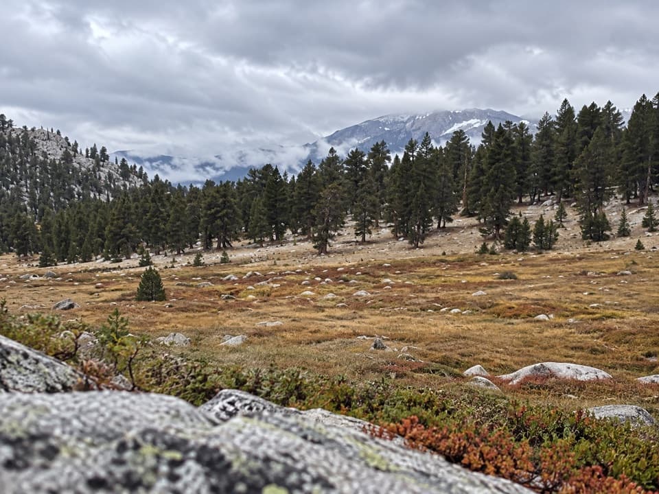
Read northbound from Horseshoe Meadow: Cottonwood Pass starts near 10,000 feet, then the route crosses Big and Little Whitney Meadows and descends to the Kern River around mile 24. After the river comes a long climb of roughly 3,700 to 4,000 feet toward Coyote Pass. The route continues through Hockett Meadow and Mineral King; Redwood Meadows is a remote grove of giant sequoias along this stretch. North of Mineral King, the climb toward Elizabeth Pass gains about 4,700 feet over 10 miles and tops out around 11,300 feet. From there the route drops through Deadman Canyon to Roaring River, then crosses Avalanche Pass on its way to Road's End.

The route's history and characterThe trail was laid out in 1974 as a more westerly, lower-elevation alternative to the John Muir…

The trail was laid out in 1974 as a more westerly, lower-elevation alternative to the John Muir Trail and named for early Sierra explorer and Sierra Club member Theodore Solomons. It still crosses high passes and deep river canyons. Its appeal is the variety: high meadows, sequoia groves, granite walls, and remote river valleys, including the canyon country around Tehipite Valley. The western Sierra feels different from a single polished through-trail because the TST is a chain of older routes with very different upkeep.

Simpson Meadow needs a current checkThe Middle Fork Kings crossing at Simpson Meadow is the biggest safety question on the line.

The Middle Fork Kings crossing at Simpson Meadow is the biggest safety question on the line. Older thru-hike accounts report the former footbridge gone; one described fording thigh-deep water. The river can rise with snowmelt, and those reports do not establish the crossing's condition today. Check directly with Kings Canyon National Park before committing to this section. Do not assume the mapped line means a bridge or a safe ford is present.

Access, permits and resupplyFor this mapped direction, start at Glacier Point.

For this mapped direction, start at Glacier Point. Glacier Point Road is seasonal, usually opening in late spring and closing in fall as conditions require. Finish at the Cottonwood Pass Trailhead at Horseshoe Meadow, at the end of Horseshoe Meadow Road; that road is also seasonal. Overnight wilderness permits are required in Yosemite and Sequoia/Kings Canyon and for Inyo National Forest wilderness trips, so check each unit's current rules and your entry permit before planning the through-route. Pets are not allowed on the full route because they are prohibited in the wilderness portions of the three parks. Resupply is limited and often needs advance arrangement; plan food carries and transport between the two distant endpoints before you leave.

Wildlife

Wildlife in Sequoia

All Sequoia wildlife maps

Sighting maps show where each species has been reported across Sequoia. Wildlife moves, so no sighting is guaranteed.

Parkwolf’s Sequoia ranking

Top-rated trails in Sequoia

All 99 trails
  1. 1Congress TrailEasy · 2.7 mi
  2. 2General Sherman Tree TrailModerate · 1 mi
  3. 3Moro Rock TrailModerate · 0.5 mi
  4. 4High Sierra TrailChallenging · 48.9 mi
  5. 5Mount Whitney TrailChallenging · 22 mi
  6. 6Lakes Trail to Pear LakeChallenging · 12.8 mi

Take Parkwolf to Sequoia.

The audio tour guide for the drive, plus offline maps, trails, and wildlife heatmaps for when the signal drops.

4.7 from 8,600+ ratings

Download Parkwolf on the App StoreGet Parkwolf on Google Play








