
Overview
About Holuhraun Lava Field Viewpoint
Why stop
- An enormous, geologically important landscape with a remarkable eruption story.
Heads up
- The remote highland approach makes this a substantial side trip.
Map
Where it is

The highest, rockiest slopes around here are a summer buffet for grizzly bears.
Vatnajökull Tour Guide
Your drive to Holuhraun Lava Field Viewpoint, narrated.
Parkwolf is a GPS audio tour guide for Vatnajökull National Park. As you drive, it chimes in with what’s ahead: hidden gems, upcoming stops, history, geology, and wildlife, right through your car’s speakers.
More stories near here in the app
- Who Saw the Raven's Hiding Place?
- Crystals Inside a Lava Bubble
- The Duck Grazing Beside the Pond
- Reading the Wind in Sand
- 298 audio storiesacross Vatnajökull’s roads, triggered by GPS as you drive
- Wildlife heatmapsfor Grey Seal, Harbor Seal, Caribou, and 13 more
- Works offlinemaps, 92 trails, 75 places, and audio download before you lose signal
- CarPlay readysimple controls built for the drive
“Fantastic app with many points of information… It’s great to just turn on while you’re driving and it gives you an audio tour of the national Park. We love it!!!!”


Guide
More about Holuhraun Lava Field Viewpoint
What this stop isHoluhraun Lava Field Viewpoint is a remote highland lookout associated with the eastern side of…
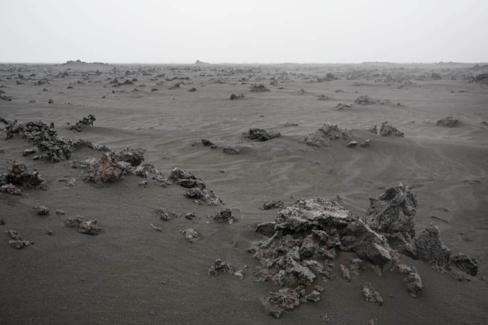
Holuhraun Lava Field Viewpoint is a remote highland lookout associated with the eastern side of Vatnajökull’s broad Holuhraun lava field. The field covers about 84 square kilometres and was made by Iceland’s huge 2014–15 eruption. Treat this as a geology stop on a highland journey; the exact pull-off and view angle are not well documented.
A landscape made in one eruptionA fissure opened on 29 August 2014, and the eruption continued until 27 February 2015—nearly…
A fissure opened on 29 August 2014, and the eruption continued until 27 February 2015—nearly six months. About 1.44 cubic kilometres of lava spread across 84 square kilometres, making this Iceland’s largest effusive eruption since Laki in 1783–84. The scale is the point: this is a whole lava landscape, not just one cone.
Magma on the moveFor about two weeks before lava reached the surface, earthquakes migrated northeast from…
For about two weeks before lava reached the surface, earthquakes migrated northeast from Bárðarbunga as magma travelled underground toward the eruption site, about 45 kilometres away. When the fissure opened, it was on an ice-free flank. Holuhraun’s name is translated as “hollow lava” or “porous lava.”
Plan it as a highland tripThe hut operator lists Holuhraun as a 19-kilometre drive from Drekagil and says access to the…
The hut operator lists Holuhraun as a 19-kilometre drive from Drekagil and says access to the highland hut is by jeep; that distance is for Holuhraun generally, not a confirmed measurement to this viewpoint. Check current road and crossing conditions before setting out. Dreki has toilets, showers and a café in summer. The park says there are no shops or gas stations in the Askja area, so plan fuel before heading in.
Wildlife
Wildlife in Vatnajökull
 23 sightingsGrey SealMost seen around 5 AMSighting map
 260 sightingsHarbor SealMost seen around 11 AMSighting map
 184 sightingsCaribouMost seen around 7 PMSighting map
 62 sightingsArctic FoxMost seen around 8 PMSighting map
 169 sightingsWhooper SwanMost seen around 5 PMSighting map
 68 sightingsAtlantic PuffinMost seen around 7 PMSighting map
Sighting maps show where each species has been reported across Vatnajökull. Wildlife moves, so no sighting is guaranteed.





