Use the lagoon-side facilities
There is parking at both the beach and the lagoon. Toilets and EV charging are at the developed lagoon-side facilities, not beside the surf; the B2 path connects the two areas under the bridge.

#3 of 47 sights in Vatnajökull
Beach · Vatnajökull National Park
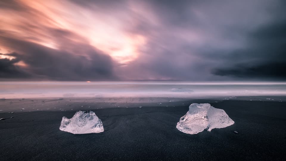
When ice washes ashore, blue blocks glow against black sand.
Photo: Giuseppe Milo, CC BY 3.0, via Wikimedia Commons
Overview
Map
Plan your stop

The highest, rockiest slopes around here are a summer buffet for grizzly bears.
Vatnajökull Tour Guide
Parkwolf is a GPS audio tour guide for Vatnajökull National Park. As you drive, it chimes in with what’s ahead: hidden gems, upcoming stops, history, geology, and wildlife, right through your car’s speakers.
Recorded for this place
Fellsfjara: Diamond Beach“Up ahead is Fellsfjara, better known as Diamond Beach, where pieces of glacial ice can wash onto black sand. The ice comes through Jökulsárlón and down the river before the waves carry it ashore.”
Plays as you drive up to Fellsfjara (Diamond Beach) in the Parkwolf Vatnajökull Tour Guide.
More stories near here in the app
“Fantastic app with many points of information… It’s great to just turn on while you’re driving and it gives you an audio tour of the national Park. We love it!!!!”


Guide
Fellsfjara is a black-sand beach beside Jökulsárlón, south of Route 1. Glacial ice from the lagoon often reaches the shore, and clear or blue pieces against the dark sand are why travelers call it Diamond Beach. The amount can change from a scatter of fragments to very little, even in summer, so treat the ice as a bonus rather than a promise. Look for one piece framed by the black sand and surf; give the waterline a wide margin because waves can surge farther up the beach than they first appear.
The park's easy B2 route starts at Eystri-Fellsfjara parking and is 1 km out and back. It passes an outdoor photo exhibition, descends to the beach, then follows the Jökulsá toward Jökulsárlón. The path goes under the road bridge; don't walk across the bridge. Interpretive signs along the river explain wildlife and glacier retreat. The trail is rated easy, but the final approach is onto natural beach sand.
Breiðamerkursandur is the outwash plain below Breiðamerkurjökull. Ice breaks from the glacier into Jökulsárlón, then pieces can travel to the beach. The park's interpretation signs make this more than a photo stop: the ice on shore is part of a landscape that is still being reshaped by the glacier's retreat.
As the climate cooled from the 13th century, Breiðamerkurjökull advanced through the following centuries. At its closest, the glacier came to about 250 metres from the sea. Retreat began in the early 20th century; lakes including Jökulsárlón, Breiðárlón and Fjallsárlón appeared in the 1930s and continue to grow. The older name Breiðársandur refers to the wider plain between Kvíá and Fellsá and comes from the farm Breiðá. Place names record settlement here almost 1,100 years ago.
The wider plain is nesting ground for great skuas and barnacle geese. Reindeer herds winter on its eastern side and can run across the road, so keep watch while driving through the area.
Wildlife
 23 sightingsGrey SealMost seen around 5 AMSighting map
 260 sightingsHarbor SealMost seen around 11 AMSighting map
 184 sightingsCaribouMost seen around 7 PMSighting map
 62 sightingsArctic FoxMost seen around 8 PMSighting map
 169 sightingsWhooper SwanMost seen around 5 PMSighting map
 68 sightingsAtlantic PuffinMost seen around 7 PMSighting map
Sighting maps show where each species has been reported across Vatnajökull. Wildlife moves, so no sighting is guaranteed.
Parkwolf’s Vatnajökull ranking

The audio tour guide for the drive, plus offline maps, trails, and wildlife heatmaps for when the signal drops.