
Overview
About Skaftárstofa Visitor Centre
Why stop
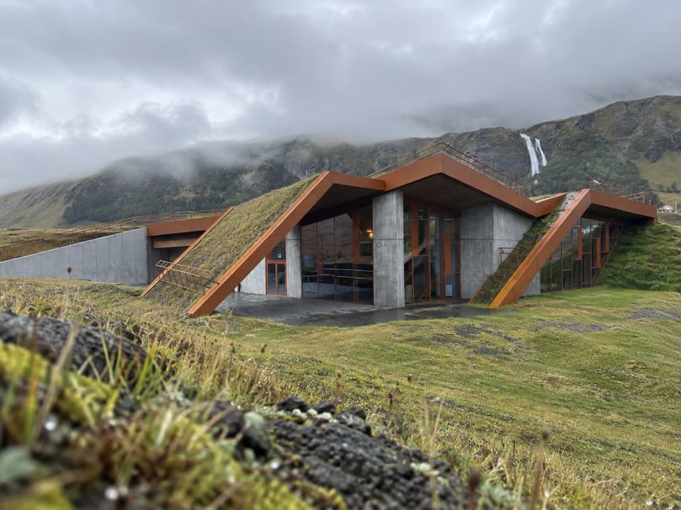
- Walkable turf roof with views toward Öræfajökull.
Map
Where it is

The highest, rockiest slopes around here are a summer buffet for grizzly bears.
Vatnajökull Tour Guide
Your drive to Skaftárstofa Visitor Centre, narrated.
Parkwolf is a GPS audio tour guide for Vatnajökull National Park. As you drive, it chimes in with what’s ahead: hidden gems, upcoming stops, history, geology, and wildlife, right through your car’s speakers.
More stories near here in the app
- Clouds Still in Sunlight
- The Convent Beneath Klaustur
- Laki's Travelling Haze
- An Iceberg Rising from Below
- 298 audio storiesacross Vatnajökull’s roads, triggered by GPS as you drive
- Wildlife heatmapsfor Grey Seal, Harbor Seal, Caribou, and 13 more
- Works offlinemaps, 92 trails, 75 places, and audio download before you lose signal
- CarPlay readysimple controls built for the drive
“Fantastic app with many points of information… It’s great to just turn on while you’re driving and it gives you an audio tour of the national Park. We love it!!!!”


Guide
More about Skaftárstofa Visitor Centre
A useful first stop before LakagígarSkaftárstofa is Vatnajökull National Park’s visitor centre at Sönghóll beside Route 1, near…
Skaftárstofa is Vatnajökull National Park’s visitor centre at Sönghóll beside Route 1, near Kirkjubæjarklaustur. It also serves as an information centre for Skaftárhreppur. Stop in before heading for Lakagígar: staff can help with local information and road conditions. The F206 and F207 to the crater row require four-wheel drive and cross four unbridged rivers that can rise in rain; that warning is for the highland drive, not the centre’s Route 1 access.
Walk across the roofThe low building is set into the hillside under a turf-covered roof, with a path running over…
The low building is set into the hillside under a turf-covered roof, with a path running over the roofline. From up there, the view reaches across the Skaftá River toward Öræfajökull and Hvannadalshnúkur. It is an unusually good reason to step outside after looking around indoors.
An exhibit shaped by the landscapeInside, displays introduce the nature and landscapes of the park.
Inside, displays introduce the nature and landscapes of the park. The floor of the exhibition space is divided into sections featuring gravel from major glacial rivers in western Vatnajökull, a small detail that ties the building back to the terrain outside. The centre opened to visitors in 2024 and was designed to sit low in the surrounding slopes, using turf from the site and Icelandic timber.
The story of the Laki cratersLakagígar is a crater row more than 29 kilometres long, with over 130 craters formed in the…
Lakagígar is a crater row more than 29 kilometres long, with over 130 craters formed in the 1783–84 Skaftáreldar eruptions. About 12 cubic kilometres of lava flowed toward settled areas in two tongues now called Eldhraun and Brunahraun. Volcanic mist, ash and gases led to livestock losses, famine and disease; the combined crisis killed about one in five Icelanders. The scale of that story explains why this small centre is a useful place to orient yourself before the remote crater route.
Take a proper breakThere is a café for coffee and cakes, a covered outdoor dining terrace, public restrooms and…
There is a café for coffee and cakes, a covered outdoor dining terrace, public restrooms and parking. The terrace looks over the Skaftá River toward the glaciers, so this works as more than a quick information stop if the weather turns.
Wildlife
Wildlife in Vatnajökull
 23 sightingsGrey SealMost seen around 5 AMSighting map
 260 sightingsHarbor SealMost seen around 11 AMSighting map
 184 sightingsCaribouMost seen around 7 PMSighting map
 62 sightingsArctic FoxMost seen around 8 PMSighting map
 169 sightingsWhooper SwanMost seen around 5 PMSighting map
 68 sightingsAtlantic PuffinMost seen around 7 PMSighting map
Sighting maps show where each species has been reported across Vatnajökull. Wildlife moves, so no sighting is guaranteed.





