1 active Blue Mountains alert
- ClosureNational Pass closed between Valley of the Waters and Slacks StairsNational Pass is closed between Valley of the Waters and Slacks Stairs due to rockfall.Official details
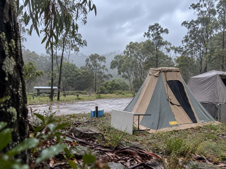
Campground · Blue Mountains National Park
A quiet tent base for the Ruby Creek mine and falls walk.


Overview
Map
Plan your stop

The highest, rockiest slopes around here are a summer buffet for grizzly bears.
Blue Mountains Tour Guide
Parkwolf is a GPS audio tour guide for Blue Mountains National Park. As you drive, it chimes in with what’s ahead: hidden gems, upcoming stops, history, geology, and wildlife, right through your car’s speakers.
See the Blue Mountains audio tourRecorded for this place
Mount Werong Campground and Ruby Creek“Mount Werong campground is coming up, a base for a simple overnight in the southern mountains.”
Plays as you drive up to Mount Werong Campground in the Parkwolf Blue Mountains Tour Guide.
More stories near here in the app
“Fantastic app with many points of information… It’s great to just turn on while you’re driving and it gives you an audio tour of the national Park. We love it!!!!”
Guide
Mount Werong is a basic campground at about 1,200 m in the southern Blue Mountains. It suits a self-sufficient overnight more than a developed holiday park: the Ruby Creek walking track starts here and leads to old mining remains and a waterfall lookout.
From Oberon, take Edith Road, then Butter Factory Lane/Shooters Hill Road and Mount Werong Road. The final approach is unsealed, and AWD or 4WD is recommended. Phone coverage is limited; carry a PLB, leave your trip plan with someone, and check wet-weather alerts before setting out. Don’t route through Burragorang Valley, where water-catchment access is restricted. Dogs aren’t allowed except certified assistance animals.
The sites are unpowered and unmarked, with some a short walk from the car. Toilets, barbecues, picnic tables and parking are listed, but there’s no food service, so bring what you need. Drinking water is listed, but reports conflict about whether it’s reliable; bring a backup and check before you depend on it. The stone hut is for temporary stays only, not a bookable cabin.
The easy Ruby Creek track follows tall forest beside the creek to a former alluvial gold mine, then continues down stone and timber steps to Ruby Creek Falls lookout. Plan on about 5.3 km return and 1.5 hours. The falls drop roughly 60 m, with views toward Kanangra-Boyd Wilderness and Boyd Plateau; an optional detour looks over the old mine shaft and machinery.
Ruby Creek was worked for alluvial gold. The miners’ bush huts are gone, but a few exotic fruit trees remain around the old hut site. This is Gundungurra and Wiradjuri Country. After dark, listen for powerful owls calling; seeing one isn’t guaranteed.
Wildlife
 58 sightingsGrey KangarooMost seen around 6 AMSighting map
 43 sightingsWombatMost seen around 6 PMSighting map
 18 sightingsRed-necked WallabyMost seen around 6 PMSighting map
 54 sightingsSwamp WallabyMost seen around 7 AMSighting map
 24 sightingsBrushtail PossumMost seen around 7 PMSighting map
 31 sightingsRing-tailed PossumMost seen around 7 PMSighting map
Sighting maps show where each species has been reported across Blue Mountains. Wildlife moves, so no sighting is guaranteed.
Keep exploring
Parkwolf’s Blue Mountains ranking

The audio tour guide for the drive, plus offline maps, trails, and wildlife heatmaps for when the signal drops.