Parking
The NPS estate map shows parking near Flat Top Manor and Bass Lake. Choose the end you plan to use; walk back along Duncan Road if you do not have a ride at the other end.

Blue Ridge Parkway, NC · VA
A historic carriage road that descends to Bass Lake.
Overview
Duncan Carriage Trail follows an old estate carriage road through Moses Cone Memorial Park, from the Entrance Road access to Bass Lake Road near Bass Lake. It is about 2.5 miles one way on a mostly wooded gravel road, with a short open stretch at former orchard pasture. The route gradually drops about 435 feet toward the lake; expect the same climb on the return. Choose it for a historic walk through the estate rather than a summit view.
 Parkwolf’s verdictIs this the hike for you?
Map & elevation
Plan your hike

The highest, rockiest slopes around here are a summer buffet for grizzly bears.
Blue Ridge Parkway Tour Guide
Parkwolf is a GPS audio tour guide for Blue Ridge Parkway. As you drive, it chimes in with what’s ahead: hidden gems, upcoming stops, history, geology, and wildlife, right through your car’s speakers.
See the Blue Ridge Parkway audio tourRecorded for this trailhead
Moses Cone Manor: House, Crafts and Carriage Roads“You're nearing Moses Cone Memorial Park, home to the white, twenty-room Flat Top Manor. Moses and Bertha Cone built it as their summer home in nineteen oh one.”
Plays as you drive up to this trailhead in the Parkwolf Blue Ridge Parkway Tour Guide.
More stories near here in the app
“…We knew we wanted to drive the Blue Ridge Parkway. The narration was impeccably timed. The facts and info provided were meaningful. Without it, the trip would not have been near as awesome.”


Trail guide
The road is a point-to-point walk, not a loop. Walking back to your starting access makes the outing about 5 miles; allow roughly 1.5 to 2 hours each way, or 3 to 4 hours for a return walk with stops. The park map shows parking near Flat Top Manor and Bass Lake. Pick the end that fits your day and return along the same road unless someone can meet you at the other end.
Duncan Road was named for G. H. Duncan, a supervisor of the Cone estate. It connects with May View Road before reaching Bass Lake Road. Most of the corridor stays under trees, while a short section opens at pasture from the former Flat Top Orchard. Native-stone retaining walls support steeper stretches, including a notable wall near the Bass Lake Road junction.
This is a multiuse carriage route, so hikers may meet horseback riders. Give horses room and keep dogs leashed. Fallen leaves and winter ice can make the gravel surface slick. No Duncan-specific water or restroom service is identified, so bring what you need for the walk.
Wildlife
 1,214 sightingsBlack BearMost seen around 7 AMSighting map
 1,021 sightingsElkMost seen around 7 AMSighting map
 2,266 sightingsWhite-tailed DeerMost seen around 6 PMSighting map
 200 sightingsCoyoteMost seen around 6 PMSighting map
 1,130 sightingsWild TurkeyMost seen around 7 AMSighting map
 255 sightingsRed-tailed HawkMost seen around 11 AMSighting map
Sighting maps show where each species has been reported across Blue Ridge Parkway. Wildlife moves, so no sighting is guaranteed.
Keep exploring
 ModerateWatkins Carriage Trail7.4 mi · 3.5 hr · 0.2 mi awayA long carriage road through the historic Cone estate.
 EasyFigure 8 Trail0.4 mi · 18 min · 0.2 mi awayA short, signed nature loop beside Moses Cone Manor.
 ModerateFlat Top Mountain Carriage Trail5.4 mi · 3 hr · 0.2 mi awayA historic carriage climb to a 360-degree mountain tower.
 EasyBass Lake Loop Trail0.7 mi · 30 min · 0.5 mi awayA short, level lap beside Bass Lake.
 ModerateDeer Park Carriage, Horse & Hiking Trail1.2 mi · 36 min · 0.7 mi awayA gravel carriage road descends toward Bass Lake through woodland.
 EasyTrout Lake Loop Trail1.5 mi · 45 min · 0.7 mi awayA quiet gravel loop circles a wooded lake on historic carriage roads.
 ModerateRich Mountain Carriage Trail8.6 mi · 4.5 hr · 0.7 mi awayA long carriage-road climb reaches an open summit pasture.
 ModerateMaze Carriage Trail4.6 mi · 2.5 hr · 0.8 mi awayA winding gravel carriage road through Moses Cone’s woods.
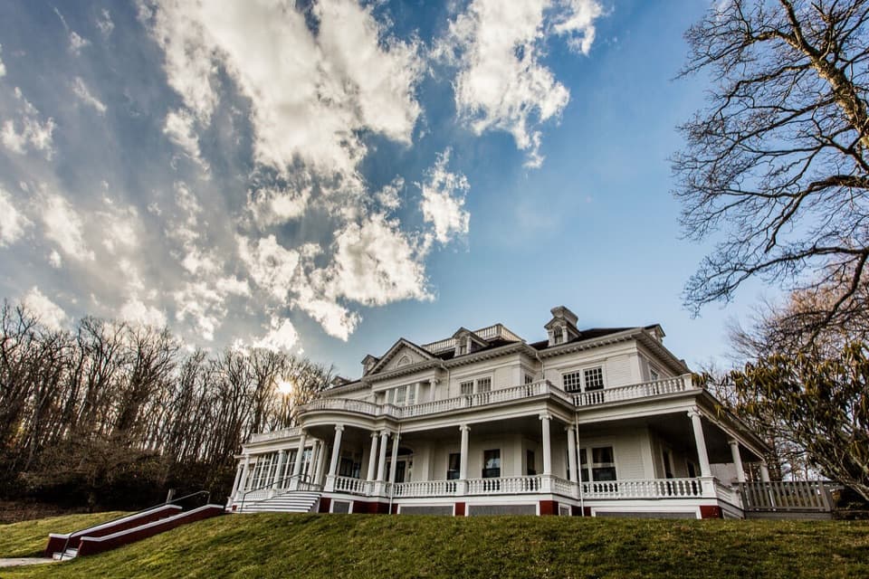 Sight · 0.2 mi awayMoses H. Cone Memorial Park and Flat Top ManorA 20-room manor anchors 25 miles of winding carriage roads
 Sight · 1.4 mi awaySims PondA quiet pond stop with a 2.3-mile loop if you want more.
 Picnic area · 1.9 mi awayPrice Park Picnic AreaA creekside meal with Boone Fork Trail right there.
 Campground · 2.4 mi awayJulian Price Park CampgroundA wooded base for Price Lake paddling and nearby Parkway hikes.
 Sight · 2.4 mi awayPrice LakeA lakeside loop for reflections and Grandfather Mountain views.
 Scenic pullout · 2.9 mi awayThunder Hill OverlookA sweeping Piedmont view with a worthwhile walk across the Parkway.
 Scenic pullout · 3.3 mi awayYadkin Valley OverlookA quick pull-off for a wide view across the Yadkin River Valley.
 Scenic pullout · 3.4 mi awayRaven Rocks OverlookA boulder perch for a northwest mountain view.
Parkwolf’s Blue Ridge Parkway ranking
The audio tour guide for the drive, plus offline maps, trails, and wildlife heatmaps for when the signal drops.





