Parking
Start at the upper level of Craggy Dome Parking Overlook, just north of the Parkway tunnel. The Craggy Gardens Visitor Center is farther south and serves a different trail access; start at the upper overlook for the 0.8-mile round trip.

#2 of 145 trails in Blue Ridge Parkway
Blue Ridge Parkway, NC · VA
A short rhododendron climb to a wide Blue Ridge panorama.
Photo: NPS
Overview
Map & elevation
Plan your hike

The highest, rockiest slopes around here are a summer buffet for grizzly bears.
Blue Ridge Parkway Tour Guide
Parkwolf is a GPS audio tour guide for Blue Ridge Parkway. As you drive, it chimes in with what’s ahead: hidden gems, upcoming stops, history, geology, and wildlife, right through your car’s speakers.
See the Blue Ridge Parkway audio tourRecorded for this trailhead
Craggy Pinnacle: A Short Summit Climb“Up ahead is Craggy Dome Overlook, where you can stop for a roadside panorama or climb to Craggy Pinnacle.”
Plays as you drive up to this trailhead in the Parkwolf Blue Ridge Parkway Tour Guide.
More stories near here in the app
“…We knew we wanted to drive the Blue Ridge Parkway. The narration was impeccably timed. The facts and info provided were meaningful. Without it, the trip would not have been near as awesome.”


Trail guide
Craggy Pinnacle Trail is a short out-and-back from the upper parking level at Craggy Dome Overlook to a rocky summit above the Parkway. This entry covers the 0.8-mile round trip, about 0.39 mile of mapped trail each way, with roughly 250 feet of climbing. Allow around 45 minutes, including time at the top. Area guides sometimes list 1.2 miles; this route uses the upper parking level and the shorter trail line, so check your starting point if another set of directions shows more. It suits anyone who wants a proper uphill walk and a wide mountain view without giving up much of the day.
Start at the upper lot, just north of the Parkway tunnel visible from the Craggy Gardens Visitor Center. The trail quickly enters thick rhododendron, which closes in around the tread and hides the view for much of the climb. Stone steps help with the grade, but the route stays uneven and climbs steadily for its short length. It’s moderate overall; the 250-foot gain explains why this doesn’t feel like a flat path from an overlook. Gnarled sweet birch and wildflowers line the way. In June, rhododendron bloom is part of the show, and wildflowers can appear from spring into fall.
Near the crest, a spur to the right leads to a separate observation point among rugged rocks. The main path continues to the summit, where the dense shrubs give way to open blueberry heath. The top has a low stone wall around its viewing area and a full circle of ridgelines. Look south for the Parkway below; west, the mountain folds continue toward Tennessee on a clear day. Cloud or haze can cover that long view, so don’t count on the horizon being sharp every visit. The rhododendron, twisted birch and open heath still make the climb distinctive when the panorama disappears.
For a photo, include a little of the low wall or rocky foreground with the ridges behind it. A tight crop of distant mountains loses the scale of the summit perch. The right-hand observation spur just before the top leads to the rugged rocks; take care there, then return to the main path rather than crossing the heath.
The route starts and ends at the upper level of Craggy Dome Parking Overlook. Follow the same trail back to the lot; the 0.8-mile figure is the complete round trip, while the stored map draws the shared corridor once. The visitor center farther south is a different trail access, so don’t use it as the start if you want this distance. Dogs are allowed on Parkway trails, but must stay under direct control on a leash no longer than six feet. The uphill is brief but noticeable, and the rocky observation spur is the roughest footing; allow time to move carefully and enjoy the summit rather than treating this as a quick roadside hop.
Wildlife
 1,214 sightingsBlack BearMost seen around 7 AMSighting map
 1,021 sightingsElkMost seen around 7 AMSighting map
 2,266 sightingsWhite-tailed DeerMost seen around 6 PMSighting map
 200 sightingsCoyoteMost seen around 6 PMSighting map
 1,130 sightingsWild TurkeyMost seen around 7 AMSighting map
 255 sightingsRed-tailed HawkMost seen around 11 AMSighting map
Sighting maps show where each species has been reported across Blue Ridge Parkway. Wildlife moves, so no sighting is guaranteed.
Keep exploring
 ModerateCraggy Gardens Trail1.2 mi · 1 hr · 0.4 mi awayA rhododendron bald opens onto Montreat and the Black Mountains.
 ChallengingDouglas Falls Trail8 mi · 7 hr · 0.7 mi awayA long forest descent to a 70-foot waterfall and hemlock groves.
 ModerateLane Pinnacle via Mountains-to-Sea Trail4.1 mi · 2.8 hr · 1.4 mi awayClimb to Lane Pinnacle along the Mountains-to-Sea Trail.
 ChallengingSnowball Mountain Trail7 mi · 4.5 hr · 1.5 mi awayHard ridge miles lead to Hawkbill Rock and the old tower site.
 ChallengingBlackstock Knob via Mountains-to-Sea Trail3 mi · 2.5 hr · 3.8 mi awayA steep ridge climb with a view before the wooded summit.
 ModerateBig Butt Trail4.4 mi · 3.5 hr · 3.8 mi awayA rocky ridge walk to Little Butt's view of Mount Mitchell.
 ModerateBlue Ridge Pinnacle Trail1.5 mi · 1.3 hr · 5.6 mi awayA short, steep loop to a rocky Blue Ridge overlook.
 ModerateRattlesnake Lodge Trail1 mi · 2 hr · 5.6 mi awayA wooded, steep climb to the ruins of a mountain retreat.
 Scenic pullout · At the trailheadCraggy Dome OverlookA roadside view of the rounded Craggy Dome.
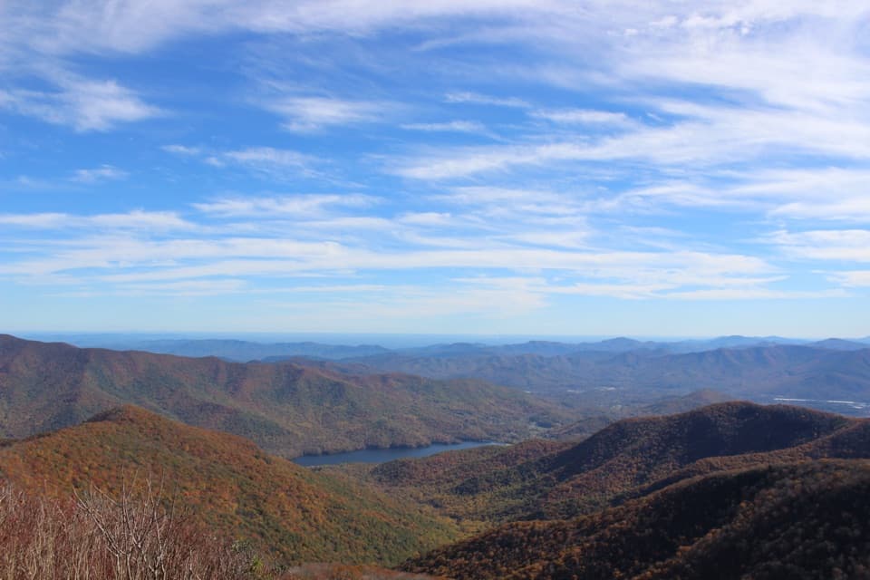 Sight · 0.2 mi awayCraggy PinnacleA short climb for a full-circle Blue Ridge panorama.
 Visitor center · 0.4 mi awayCraggy Gardens Visitor CenterShort climb to a rhododendron bald and a CCC shelter.
 Sight · 0.7 mi awayGraybeard Mountain OverlookSeven peaks below Graybeard, sometimes capped by a gray cloud.
 Picnic area · 1.1 mi awayCraggy Gardens Picnic AreaA cool high-country picnic among summer wildflowers.
 Sight · 2.7 mi awayGlassmine Falls OverlookAfter rain, look for the falls across Horse Range Ridge.
 Scenic pullout · 3.8 mi awayWalker Knob OverlookAt milepost 359.8, this is a better trailhead than viewpoint.
 Sight · 4.6 mi awayLane Pinnacle OverlookA quick pull-off lines up three named mountain landmarks.
Parkwolf’s Blue Ridge Parkway ranking

The audio tour guide for the drive, plus offline maps, trails, and wildlife heatmaps for when the signal drops.





