Cape Cod Rail Trail in Cape Cod National Seashore

Cape Cod National Seashore, MA

Cape Cod Rail Trail

A mostly flat, paved 26-mile ride through six Cape towns.

Photo: Wikimedia Commons
Length
26mi
Time
4hr
Elev. change
112ft
Difficulty
Moderate
  • Dogs allowed
  • High point 115 ft
Parkwolf audio tour56 stories across Cape Cod’s roads

Overview

About Cape Cod Rail Trail

Why go

  • A paved, mostly level route with access points in several towns
  • Easy to shorten into a section ride

Heads up

  • Busy road crossings and tunnels need attention
  • The full one-way distance takes most of a day on foot

Map & elevation

The route

Loading the Cape Cod map
Full map
Elevation3–115 ft
TrailheadCape Cod Rail Trail Trailhead at Station Avenue41.68549, -70.20846
Keep this map with you offline in the Parkwolf app

Plan your hike

Before you go

Parking

Start at the Cape Cod Rail Trail trailhead and parking area at 460 Station Avenue in South Yarmouth. DCR lists additional free access parking along the route, including at LeCount Hollow Road in Wellfleet; parking inside Nickerson State Park is fee-charged seasonally. Arrange a pickup or second vehicle for a through ride.


Safety

The route crosses busy roads and has several tunnels. Watch for sand, standing water, bumps in the pavement and low branches. Cyclists should walk bikes through tunnels and underpasses and follow the 15 mph speed limit.

1 active Cape Cod alert

  • CautionSharks active in park waters through OctoberSharks are active in park waters through October; heed beach guidelines and signage before entering the water.Official details
Cape Cod alerts
A park ranger sits on a dash-mounted phone, talking, as Parkwolf’s Tour Guide plays “Army Cutworm Moths: A Grizzly Bear Buffet” on Grand Loop Road below Dunraven Pass in Yellowstone
Parkwolf Tour GuideThe highest, rockiest slopes around here are a summer buffet for grizzly bears.

Cape Cod Tour Guide

Your drive to Cape Cod Rail Trail, narrated.

Parkwolf is a GPS audio tour guide for Cape Cod National Seashore. As you drive, it chimes in with what’s ahead: hidden gems, upcoming stops, history, geology, and wildlife, right through your car’s speakers.

  • 56 audio storiesacross Cape Cod’s roads, triggered by GPS as you drive
  • Wildlife heatmapsfor Gray Seal, Coyote, Red Fox, and 13 more
  • Works offlinemaps, 32 trails, 55 places, and audio download before you lose signal
  • CarPlay readysimple controls built for the drive
★★★★★
“Fantastic app with many points of information… It’s great to just turn on while you’re driving and it gives you an audio tour of the national Park. We love it!!!!”
JMJamesApp Store review
Download Parkwolf on the App StoreGet Parkwolf on Google Play

4.7 from 8,600+ ratings

Trail guide

Hiking Cape Cod Rail Trail

The full routeCape Cod Rail Trail is a paved, point-to-point shared-use route from South Yarmouth to…

Cape Cod Rail Trail is a paved, point-to-point shared-use route from South Yarmouth to Wellfleet. The through route is about 26 miles one way. DCR rounds it to 25 miles in its overview and 26 in the biking details; the mapped line from Stations Avenue to the Wellfleet end measures 25.98 miles. It is mostly level, and works best as a bike ride: allow about three to four hours of riding, plus stops. Walking the whole route is a full-day commitment, so on foot it's easier to choose an access point and go out and back.

What the route asks of youThe asphalt path runs through six Cape towns, linking local parks and access points.

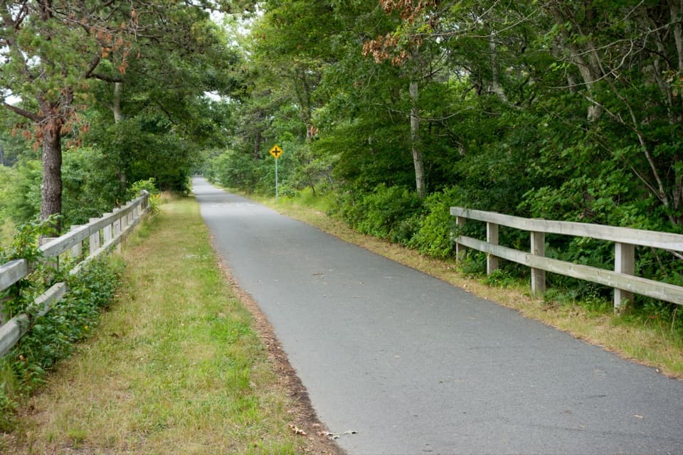
The asphalt path runs through six Cape towns, linking local parks and access points. Busy road crossings and several tunnels break up the easy grades. Around Orleans, the mapped bicycle route uses short on-road links on West Road and Salty Ridge Road, so stay with the signed route through town. Sand, standing water, pavement bumps and low branches can catch a fast rider.

Sharing the path and planning accessKeep right, signal before passing and stay under the 15 mph speed limit.

Keep right, signal before passing and stay under the 15 mph speed limit. Cyclists should walk their bikes through tunnels and underpasses. Dogs are allowed. The South Yarmouth start is at the Stations Avenue trailhead; DCR also lists free parking at Route 134 in South Dennis, Headwaters Drive in Harwich, Route 137 in Brewster, Orleans Center, Salt Pond Visitor Center in Eastham, the Marconi area and LeCount Hollow Road in Wellfleet. A one-way ride needs a pickup or second vehicle. Parking at Nickerson State Park is fee-charged seasonally.

Wildlife

Wildlife in Cape Cod

All Cape Cod wildlife maps

Sighting maps show where each species has been reported across Cape Cod. Wildlife moves, so no sighting is guaranteed.

Parkwolf’s Cape Cod ranking

Top-rated trails in Cape Cod

All 32 trails
  1. 1Great Island TrailModerate · 3.9 mi
  2. 2Fort Hill TrailEasy · 1 mi
  3. 3Atlantic White Cedar Swamp TrailModerate · 1.2 mi
  4. 4Nauset Marsh TrailEasy · 1.3 mi
  5. 5Hatches Harbor TrailModerate · 3.5 mi
  6. 6Long Point Lighthouse TrailModerate · 5.5 mi

Take Parkwolf to Cape Cod.

The audio tour guide for the drive, plus offline maps, trails, and wildlife heatmaps for when the signal drops.

4.7 from 8,600+ ratings

Download Parkwolf on the App StoreGet Parkwolf on Google Play