
Place · 4 mi away
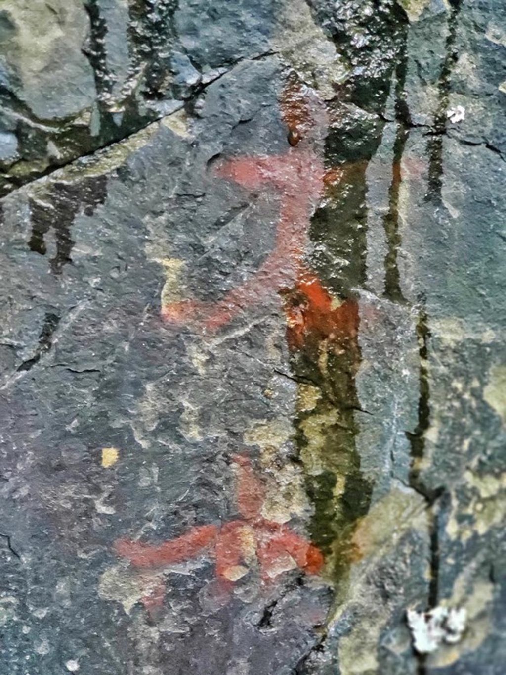
If you’re drawn to deep-time stories, Clam Cove delivers. Tucked along a remote coast, this small rock-shelter site preserves some of Alaska’s rare pictographs—one of only a handful documented in the state’s national parks. It’s not a casual stop: it’s remote, facility-free, and the art is fragile. But for those who make the effort, it’s a powerful glimpse into maritime lifeways along Cook Inlet.
Two panels of brick‑red imagery depict umiak boats, harpoons, sea mammals (including whales), and people in ocean‑going scenes. The motifs align with traditions seen across Southcentral Alaska and even echo far‑flung Siberian petroglyphs. Expect a modest site in a rugged coastal setting—this is about the story in the rock, not a big overlook or developed exhibit.
Archaeological work here goes back decades, with radiocarbon dates from nearby deposits pointing to activity roughly 1,700 years ago, consistent with the Kachemak Tradition. The site sits at a cultural crossroads historically used by Dena’ina, Yup’ik, and Alutiiq (Sugpiaq) peoples, and the imagery likely ties most closely to Alutiiq traditions. It’s important enough to be listed on the National Register of Historic Places. Locally, the Dena’ina know this bay as Niłghenk’enulyun ("mixed vegetation grown together").
Analyses upended the usual assumption of red ochre: the pigment shows very low iron and likely came from a specific local claystone rather than ochre, vermilion, or realgar. It’s another reminder that ingenuity and local geology shaped ancient art, too.
The panels are deteriorating—more moisture and runoff are accelerating lichen growth and exfoliation of the rock surface. The park actively monitors the site and works with descendant communities. Your role is simple: look, don’t touch. Never wet, trace, chalk, or brush the images, and don’t disturb surrounding soils or collect anything.
There’s no road access, no trailhead, no restroom—nothing developed. Reaching the coast typically means chartering a boat or floatplane and planning around tides, weather, and surf; expect a beach landing, not docks or signs. Rock‑art locations are sensitive and often lack public coordinates, so check with the park for current guidance and appropriate viewing practices. Confirm land status before approaching the shore, respect private parcels, and pack out everything (a wag bag is smart).
There are no posted hours or crowds—your window is dictated by safe weather and tide conditions. Aim for a fair‑weather, low‑tide visit that allows careful, dry viewing. Coordinate timing and approach with park staff and your pilot or captain.
Place · 4 mi away
Place · 6 mi away
Place · 11.3 mi away

Place · 12.8 mi away
Challenging · 51.5 mi away
Moderate · 51.5 mi away
Easy · 51.5 mi away
Easy · 51.5 mi away

Parkwolf Tour Guide
