Sunken Trace in Natchez Trace Parkway

#8 of 49 sights in Natchez Trace

Sight · Natchez Trace Parkway

Sunken Trace

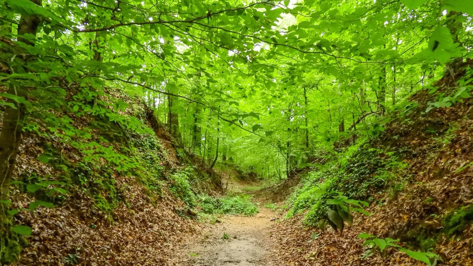
A tunnel-like gully where centuries of travelers wore the road down

Photo: National Park Service
Type
Sight
Audio stories
3 nearby
  • Parking
  • Picnic tables
  • Scenic viewpoint
  • Trailhead

Hear the audio tour

Sunken Trace

Overview

About Sunken Trace

Why stop

  • Deep, tangible Old Trace erosion
  • Memorable history-and-photo payoff in minutes

Heads up

  • Short stop rather than a full hike
  • Steep descent into the gully

Map

Where it is

Loading the Natchez Trace map
Full map
SightSunken Trace31.97060, -90.95604
Keep this map with you offline in the Parkwolf app

Plan your stop

Before you go

Best time to go

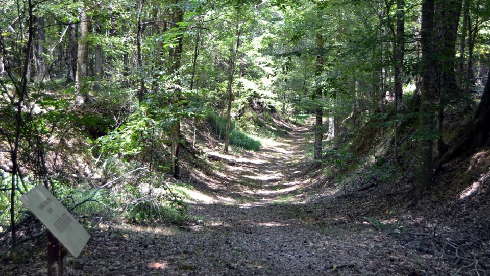
Soft, overcast light works nicely here, since the canopy keeps the gully dim and contrast can get harsh in strong sun. Stand at the bottom and shoot back along the corridor to show the depth of the banks. When the trees are in leaf, the canopy closes overhead and turns the cut into a green, tunnel-like corridor.


Access and terrain

  • Parking sits right at the stop, and it is free and plentiful.
  • There is a picnic table if you want to break up a long drive.
  • The walking route is a natural dirt path with a slope and uneven footing, so wear closed shoes with decent grip and watch your step on the way down.
  • Restrooms are limited along this stretch of the Parkway, so handle that before you set out.

4 active Natchez Trace alerts

  • ClosureParkway sections closed for bridge and road constructionTwo Natchez Trace Parkway sections are closed to through traffic; follow the signed detours.Official details
  • ClosureMount Locust historic stand closedThe historic stand at Mount Locust Inn & Plantation (MP 15.5) is closed because of structural concerns.Official details
See all 4 alerts
A park ranger sits on a dash-mounted phone, talking, as Parkwolf’s Tour Guide plays “Army Cutworm Moths: A Grizzly Bear Buffet” on Grand Loop Road below Dunraven Pass in Yellowstone
Parkwolf Tour GuideThe highest, rockiest slopes around here are a summer buffet for grizzly bears.

Natchez Trace Tour Guide

Your drive to Sunken Trace, narrated.

Parkwolf is a GPS audio tour guide for Natchez Trace Parkway. As you drive, it chimes in with what’s ahead: hidden gems, upcoming stops, history, geology, and wildlife, right through your car’s speakers.

Recorded for this place

Sunken Trace
0:00 / 0:34
“You're coming up on Sunken Trace, where a short walk drops into a piece of the old road itself. In places the banks rise about fifteen feet above you.”

Plays as you drive up to Sunken Trace in the Parkwolf Natchez Trace Tour Guide.

More stories near here in the app

  • Purple Rings on a Stem
  • The Spiny Caterpillar on Maypop
  • The Figure on the Copper
  • The Green Curtain
  • 272 audio storiesacross Natchez Trace’s roads, triggered by GPS as you drive
  • Wildlife heatmapsfor American Alligator, White-tailed Deer, Wild Turkey, and 9 more
  • Works offlinemaps, 26 trails, 62 places, and audio download before you lose signal
  • CarPlay readysimple controls built for the drive
★★★★★
“Fantastic app with many points of information… It’s great to just turn on while you’re driving and it gives you an audio tour of the national Park. We love it!!!!”
JMJamesApp Store review
Download Parkwolf on the App StoreGet Parkwolf on Google Play

4.7 from 8,600+ ratings

Guide

More about Sunken Trace

Why it stands outAt milepost 41.

At milepost 41.5 near Port Gibson, a short trail drops into a deeply eroded, preserved cut of the Old Trace. The path runs along the bottom of a narrow, tree-shaded gully with steep eroded banks rising on both sides, in places roughly 15 feet high. The effect is almost tunnel-like, and the perspective makes this a natural photo stop: you are standing in a road that was worn down by feet, hooves, and wagon wheels rather than dug by machines.

The history in shortWhat you see here is a preserved segment, not the entire original route.

What you see here is a preserved segment, not the entire original route.

  • The corridor began as animal trails, later used by American Indian tribes traveling the region.
  • As the United States pushed west in the late 1700s and early 1800s, steady traffic trampled the rough route into a marked road.
  • The local loess soil is fine and soft, so thousands of walkers, riders, and wagons ground the surface lower and lower until sections sank well below the surrounding forest floor.
What the walk feels likeFrom the parking area the trail starts with a short but fairly steep descent.

From the parking area the trail starts with a short but fairly steep descent. Once you reach the bottom it becomes an easy, mostly level stroll on soft ground, and the short paths end after about a hundred yards. Plan on five to thirty minutes depending on how long you linger and take pictures.

Honest drawbacksThis is a brief stop, not a hike.

This is a brief stop, not a hike. The best perspective requires that steep little descent, which will not suit everyone, and visitors who expect a long trail will be through it in minutes. Treat it as one strong stop folded into a longer Parkway drive.

Wildlife

Wildlife in Natchez Trace

All Natchez Trace wildlife maps

Sighting maps show where each species has been reported across Natchez Trace. Wildlife moves, so no sighting is guaranteed.

Parkwolf’s Natchez Trace ranking

Top sights in Natchez Trace

All 62 places
  1. 1Double Arch Bridge at Birdsong HollowSight
  2. 2Cypress SwampSight
  3. 3Jackson FallsSight
  4. 4Emerald MoundSight
  5. 5Reservoir OverlookSight
  6. 6Mount Locust Historic HouseSight

Take Parkwolf to Natchez Trace.

The audio tour guide for the drive, plus offline maps, trails, and wildlife heatmaps for when the signal drops.

4.7 from 8,600+ ratings

Download Parkwolf on the App StoreGet Parkwolf on Google Play