Sombrero Reef in Overseas Highway

Sight · Overseas Highway

Sombrero Reef

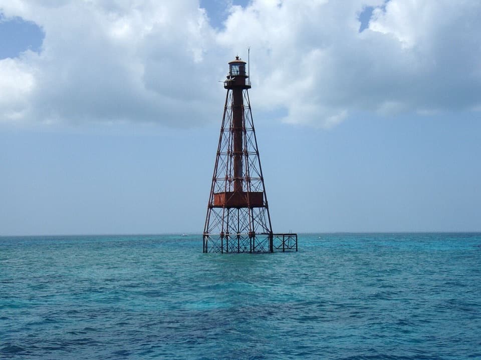
A shallow reef with a 142-foot light at its northern edge.

Photo: Wikimedia Commons

Overview

About Sombrero Reef

Why stop

  • Shallow reef ridges, fish and turtles make a rewarding snorkel or dive.

Heads up

  • Boat-only access and open-water chop can make the trip uncomfortable.

Map

Where it is

Loading the Overseas Highway map
Full map
SightSombrero Reef24.62755, -81.11085
Keep this map with you offline in the Parkwolf app

Plan your stop

Before you go

3 active Overseas Highway alerts

  • CautionCoastal flooding across the Florida KeysMentions Florida Keys, referenced in this guideA Coastal Flood Warning remains in effect for the Upper Keys and Coastal Flood Advisories remain in effect for the Middle and Lower Keys until 5 a.m.Official details
  • CautionNighttime lane closures on Seven Mile BridgeExpect possible nighttime lane closures on Seven Mile Bridge for FDOT’s rehabilitation project to repair and strengthen the bridge.Official details

See all 3 alerts
A park ranger sits on a dash-mounted phone, talking, as Parkwolf’s Tour Guide plays “Army Cutworm Moths: A Grizzly Bear Buffet” on Grand Loop Road below Dunraven Pass in Yellowstone
Parkwolf Tour GuideThe highest, rockiest slopes around here are a summer buffet for grizzly bears.

Overseas Highway Tour Guide

Your drive to Sombrero Reef, narrated.

Parkwolf is a GPS audio tour guide for Overseas Highway. As you drive, it chimes in with what’s ahead: hidden gems, upcoming stops, history, geology, and wildlife, right through your car’s speakers.

See the Overseas Highway audio tour

More stories near here in the app

  • Sombrero Beach: Sand and Picnic Shade
  • Old Seven Mile Bridge and Pigeon Key
  • The Feet Between the Spines
  • After the Pelican Splash
  • 136 audio storiesacross Overseas Highway’s roads, triggered by GPS as you drive
  • Wildlife heatmapsfor Crocodile, Alligator, Manatee, and 13 more
  • Works offlinemaps, 26 trails, 88 places, and audio download before you lose signal
  • CarPlay readysimple controls built for the drive
★★★★★
“Fantastic app with many points of information… It’s great to just turn on while you’re driving and it gives you an audio tour of the national Park. We love it!!!!”
JMJamesApp Store review
Download Parkwolf on the App StoreGet Parkwolf on Google Play

4.7 from 8,600+ ratings

Guide

More about Sombrero Reef

A reef reached by boatSombrero Reef is a shallow coral reef and sanctuary area about four miles offshore from Boot…

Sombrero Reef is a shallow coral reef and sanctuary area about four miles offshore from Boot Key near Marathon. The protected area covers 208 acres and has a triangular outline. This is a snorkel or dive trip, not a roadside pullout: reach it by boat, and don’t drive to the offshore map pin.

Snorkel the ridgesBelow the surface, coral ridges alternate with sandy channels in a pattern called spur and…

Below the surface, coral ridges alternate with sandy channels in a pattern called spur and groove. Depths in the protected area stay under 30 feet, and the reef draws visitors for snorkeling and diving. People often talk about fish, turtles and other marine life, though visibility and what you see vary with conditions.

The light on the northern edgeThe red skeletal tower of Sombrero Key Light stands where the reef meets open water.

The red skeletal tower of Sombrero Key Light stands where the reef meets open water. Built in 1858 and rising 142 feet above the sea, it is the tallest lighthouse in the Florida Keys. The tower is not an attraction to climb or visit on foot; see it from the water. For a photo, leave open sea around the light so the frame shows how far offshore it stands.

Plan for open waterBoat excursions leave from the Marathon area, while the reef itself has no road or shore…

Boat excursions leave from the Marathon area, while the reef itself has no road or shore arrival. Open-water chop can make the ride or snorkeling uncomfortable, so conditions matter even on a sunny day. The 2023 marine heat wave caused widespread coral bleaching and mortality; older pictures can give a rosier impression of coral color and health than the reef can promise now.

Use a mooring buoy when one is available. In the protected area, do not touch or stand on coral, fish, or collect.

Wildlife

Wildlife in Overseas Highway

All Overseas Highway wildlife maps

Sighting maps show where each species has been reported across Overseas Highway. Wildlife moves, so no sighting is guaranteed.

Parkwolf’s Overseas Highway ranking

Top sights in Overseas Highway

All 88 places
  1. 1Old Seven Mile BridgeSight
  2. 2Southernmost Point BuoySight
  3. 3Mallory SquareSight
  4. 4Calusa BeachBeach
  5. 5Ernest Hemingway Home and MuseumSight
  6. 6Robbie’s of IslamoradaSight

Take Parkwolf to Overseas Highway.

The audio tour guide for the drive, plus offline maps, trails, and wildlife heatmaps for when the signal drops.

4.7 from 8,600+ ratings

Download Parkwolf on the App StoreGet Parkwolf on Google Play