
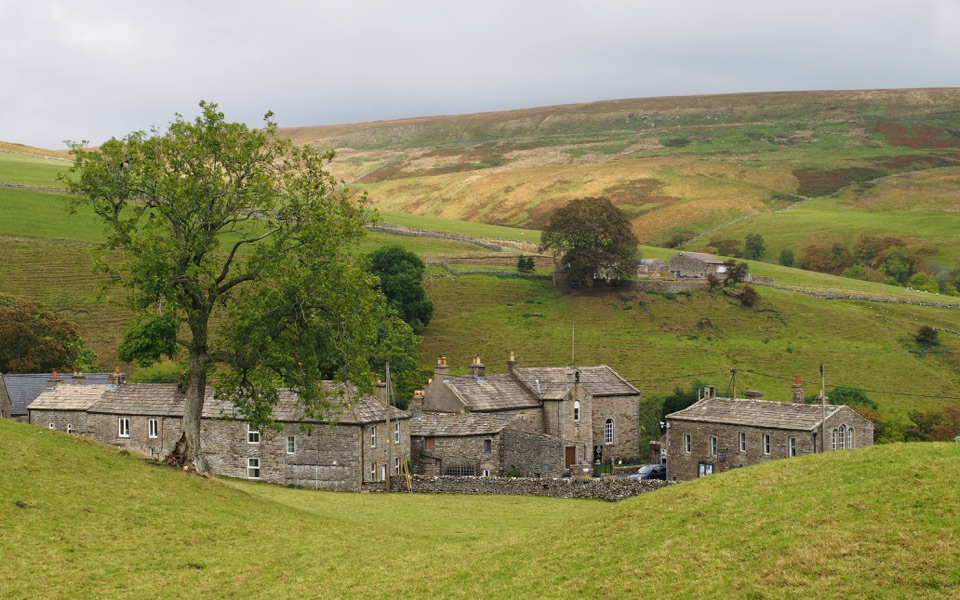
Coast to Coast Path in Yorkshire Dales National Park

#8 of 99 trails in Yorkshire Dales

Yorkshire Dales National Park, EN

Coast to Coast Path

190 one-way miles from Irish Sea surf to heather moor and cliff

Photo: Wikimedia Commons
Length
305.8km
Time
4.1days
Elev. change
542m
Difficulty
Challenging
  • Dogs allowed
  • High point 553 m
Parkwolf audio tour298 stories across Yorkshire Dales’s roads

Overview

About Coast to Coast Path

Why go

  • A true coast-to-coast crossing through three national parks
  • Huge variety from sea cliffs to fells, dales and heather moor
  • Strong multi-day route with memorable villages and heritage

Heads up

  • Demanding western fells and long remote days
  • Point-to-point logistics require careful transport and overnight planning

Map & elevation

The route

Loading the Yorkshire Dales map
Full map
Elevation11–553 m
TrailheadSt Bees Foreshore54.49040, -3.60393
Keep this map with you offline in the Parkwolf app

Plan your hike

Before you go

Parking

Start at St Bees Foreshore. St Bees Beachfront Car Park on Firth Drive serves the foreshore; the route ends at Robin Hood's Bay, so arrange onward transport before setting out. Rail reaches St Bees, and buses connect the finish toward Whitby station.


Best time to go

The route is signed with the National Trail acorn alongside public rights of way markers, but signage does not replace map and compass work on high, featureless moorland in poor visibility. Phone reception is patchy across the fells and moors, so carry paper backup and tell someone your plan. Spring through autumn is the best window for daylight, ground conditions and services. Long summer evenings and early mornings give the softest light for photography, particularly over heather in late summer and along the final cliffs.

Safety

The western fells and higher moors are steep, remote and exposed to fast-changing weather, with rough or boggy footing and route-finding challenges in poor visibility. Mobile reception is patchy. Dogs are allowed on rights of way but need close control near livestock, cliffs and nesting birds; on North York Moors moorland use the required short lead.

1 active Yorkshire Dales alert

  • ClosureTemporary closures on public rights of wayAvoid the listed sections of public rights of way while their temporary closures or pedestrian prohibition are in force. - Public Bridleway No. 52 (05.Official details
Yorkshire Dales alerts
A park ranger sits on a dash-mounted phone, talking, as Parkwolf’s Tour Guide plays “Army Cutworm Moths: A Grizzly Bear Buffet” on Grand Loop Road below Dunraven Pass in Yellowstone
Parkwolf Tour GuideThe highest, rockiest slopes around here are a summer buffet for grizzly bears.

Yorkshire Dales Tour Guide

Your drive to Coast to Coast Path, narrated.

Parkwolf is a GPS audio tour guide for Yorkshire Dales National Park. As you drive, it chimes in with what’s ahead: hidden gems, upcoming stops, history, geology, and wildlife, right through your car’s speakers.

  • 298 audio storiesacross Yorkshire Dales’s roads, triggered by GPS as you drive
  • Wildlife heatmapsfor Eurasian Otter, Atlantic Salmon, Short-eared Owl, and 13 more
  • Works offlinemaps, 99 trails, 63 places, and audio download before you lose signal
  • CarPlay readysimple controls built for the drive
★★★★★
“Fantastic app with many points of information… It’s great to just turn on while you’re driving and it gives you an audio tour of the national Park. We love it!!!!”
JMJamesApp Store review
Download Parkwolf on the App StoreGet Parkwolf on Google Play

4.7 from 8,600+ ratings

Trail guide

Hiking Coast to Coast Path

The shape of the walkThis is the full Coast to Coast Path National Trail, a point-to-point crossing of northern…

This is the full Coast to Coast Path National Trail, a point-to-point crossing of northern England from St Bees Foreshore on the Irish Sea to Robin Hood's Bay on the North Sea. The official distance is 190 miles (306 km) one way, and most walkers take 12 to 15 days. It is not a loop and not an out-and-back, so the finish leaves you a long way from the start. Roughly the last 50 miles fall inside the North York Moors, but the record here covers the whole trail rather than that final stretch alone.

Stages and payoffThe usual sequence runs St Bees to Ennerdale Bridge, Rosthwaite, Patterdale, Shap, Kirkby…

The usual sequence runs St Bees to Ennerdale Bridge, Rosthwaite, Patterdale, Shap, Kirkby Stephen, Keld, Reeth and Richmond, then over the Vale of Mowbray and Cleveland Hills before crossing the moors to Glaisdale, Grosmont and Falling Foss and dropping into Robin Hood's Bay. The reward is the sheer variety: sea cliffs, high fells, limestone country, dale villages, riverside miles, farmland and finally open heather moorland and a second coast.

Difficulty and footingRated 8/10 and genuinely demanding as a continuous walk.

Rated 8/10 and genuinely demanding as a continuous walk. The western Lake District section is the hardest, with steep, hilly and remote ground; later sections include easier lower-level walking and flat agricultural miles. Surfaces change constantly between cliff paths, fell paths, rocky and boggy upland, bridleways, lanes, forest tracks, riverside paths and village streets. Expect wet feet on the uplands and slow going where the ground is stony or peaty. Some sections have optional lower-level alternatives; the line stored here follows the official main route only.

Landscape and heritageHigh fells and upland rivers give way to upland hay meadows, Atlantic oakwood, limestone…

High fells and upland rivers give way to upland hay meadows, Atlantic oakwood, limestone outcrops, plantations and working farms. Human traces are everywhere: castles and priories, slate quarries, Swaledale lead mines and the iron and alum workings of the North York Moors. Wildlife interest is broad rather than guaranteed, with upland birds, ground-nesting moorland birds and meadow species along the way.

DogsDogs are welcome on public rights of way, with real restrictions.

Dogs are welcome on public rights of way, with real restrictions. Livestock is common in farmland, so keep dogs on a short lead or to heel near stock. Coastal paths include unfenced high cliffs. On moorland, dogs must stay on public rights of way in most places, and from 1 March to 31 July they must be on a lead shorter than 2 metres to protect ground-nesting birds.

Access, parking and logisticsThe start is at St Bees Foreshore, served by the beachfront car park on Firth Drive, with rail…

The start is at St Bees Foreshore, served by the beachfront car park on Firth Drive, with rail access to St Bees from Carlisle or Lancaster. At the eastern end, buses connect Robin Hood's Bay toward Whitby station. Because the route is one way, plan return travel, luggage and overnight stops before you set out. There is no general route-wide wild camping entitlement, so book accommodation or get landowner permission rather than assuming you can pitch.

If you want something shorterWalkers drawn mainly to moorland and sea cliffs, rather than a full country crossing, often…

Walkers drawn mainly to moorland and sea cliffs, rather than a full country crossing, often prefer the Cleveland Way, which keeps to the North York Moors and its coast in a far more compact package.

Wildlife

Wildlife in Yorkshire Dales

All Yorkshire Dales wildlife maps

Sighting maps show where each species has been reported across Yorkshire Dales. Wildlife moves, so no sighting is guaranteed.

Parkwolf’s Yorkshire Dales ranking

Top-rated trails in Yorkshire Dales

All 99 trails
  1. 1Yorkshire Three Peaks CircularChallenging · 38.6 km
  2. 2Malham Landscape TrailModerate · 7.2 km
  3. 3Ingleton Waterfalls TrailModerate · 6.9 km
  4. 4Pen-y-ghent CircularModerate · 9.7 km
  5. 5Ingleborough from ClaphamChallenging · 16.1 km
  6. 6Whernside CircularChallenging · 12.6 km

Take Parkwolf to Yorkshire Dales.

The audio tour guide for the drive, plus offline maps, trails, and wildlife heatmaps for when the signal drops.

4.7 from 8,600+ ratings

Download Parkwolf on the App StoreGet Parkwolf on Google Play











