Pennine Way in Yorkshire Dales National Park

#7 of 99 trails in Yorkshire Dales

Yorkshire Dales National Park, EN

Pennine Way

Edale to Kirk Yetholm: 268 miles of bog, flagstone and high moor

Photo: Wikimedia Commons
Length
431.3km
Time
17.5hr
Elev. change
752m
Difficulty
Challenging
  • Dogs allowed
  • High point 864 m
Parkwolf audio tour298 stories across Yorkshire Dales’s roads

Overview

About Pennine Way

Why go

  • England’s oldest National Trail
  • Exceptional variety of landscapes

Heads up

  • Long, exposed and remote sections
  • Wet bog and difficult weather
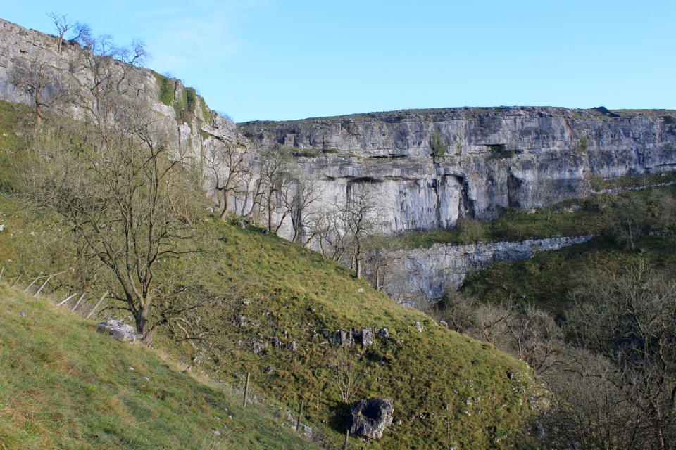
It opens hard with Kinder Scout and Bleaklow Head, then works through the South Pennines before the limestone country around Malham Cove and Malham Tarn. Fountains Fell and Pen-y-ghent come next, then old packhorse tracks and Roman road over Cam Fell and Dodd Fell into Hawes. North of there it gets bigger and emptier: Great Shunner Fell, Tan Hill, then Upper Teesdale with High Force and the rim of High Cup Nick. After Alston you cross Hadrian's Wall country, then finish over the Cheviots.
Parkwolf’s verdictThe sequence and the payoff

Map & elevation

The route

Loading the Yorkshire Dales map
Full map
Elevation112–864 m
TrailheadThe Old Nags Head, Edale53.37069, -1.81686
Keep this map with you offline in the Parkwolf app

Plan your hike

Before you go

Parking

Point-to-point logistics: start at The Old Nags Head in Edale and finish in Kirk Yetholm. Both ends have public transport connections, but plan the return journey before setting out. Resupply and overnight stops need arranging along the route.

Best time to go

The trail is open year-round, but the Pennines are windswept, get heavy rain, and can hold snow in winter. Mid-May to September usually gives the best conditions and the longest daylight. Even then, plan for a couple of days of horizontal rain and have bail-out options in mind.

Safety

A serious multi-day route with exposed high ground, wet peat bogs, steep ascents and descents, rough footing, limited water and patchy mobile reception. Carry navigation equipment and take care on rocky or slippery sections.

1 active Yorkshire Dales alert

  • ClosureTemporary closures on public rights of wayAvoid the listed sections of public rights of way while their temporary closures or pedestrian prohibition are in force. - Public Bridleway No. 52 (05.Official details
Yorkshire Dales alerts
A park ranger sits on a dash-mounted phone, talking, as Parkwolf’s Tour Guide plays “Army Cutworm Moths: A Grizzly Bear Buffet” on Grand Loop Road below Dunraven Pass in Yellowstone
Parkwolf Tour GuideThe highest, rockiest slopes around here are a summer buffet for grizzly bears.

Yorkshire Dales Tour Guide

Your drive to Pennine Way, narrated.

Parkwolf is a GPS audio tour guide for Yorkshire Dales National Park. As you drive, it chimes in with what’s ahead: hidden gems, upcoming stops, history, geology, and wildlife, right through your car’s speakers.

  • 298 audio storiesacross Yorkshire Dales’s roads, triggered by GPS as you drive
  • Wildlife heatmapsfor Eurasian Otter, Atlantic Salmon, Short-eared Owl, and 13 more
  • Works offlinemaps, 99 trails, 63 places, and audio download before you lose signal
  • CarPlay readysimple controls built for the drive
★★★★★
“Fantastic app with many points of information… It’s great to just turn on while you’re driving and it gives you an audio tour of the national Park. We love it!!!!”
JMJamesApp Store review
Download Parkwolf on the App StoreGet Parkwolf on Google Play

4.7 from 8,600+ ratings

Trail guide

Hiking Pennine Way

What it isA point to point, south to north walk up the spine of northern England, starting at The Old…

A point to point, south to north walk up the spine of northern England, starting at The Old Nags Head in Edale and finishing at Kirk Yetholm in the Scottish Borders. The official full-route convention is 268 miles (431 km), and most walkers take 16 to 19 days. This is a serious multi-day undertaking rather than a long day out, and it rewards people who are happy on rough, exposed ground for hours at a time.

Why the mileage variesThe 268-mile figure adds up every officially recognised line, including both sides of the Bowes…

The 268-mile figure adds up every officially recognised line, including both sides of the Bowes Loop, both approaches into Kirk Yetholm, the High Cup Nick alternative and the detour over The Cheviot summit. Nobody walks all of those in one go, so a single end-to-end line comes out nearer 253 miles. The standard main corridor, which is what most route files and mapping show, measures about 258.5 miles and leaves the optional alternatives out. Pick your variants during planning and your own total will land somewhere in that band.

Difficulty and footingExpect the full range: firm smooth track in places, but also stone flags, wet peat bog, rough…

Expect the full range: firm smooth track in places, but also stone flags, wet peat bog, rough tussocky moorland, narrow uneven paths, steep ascents and descents, field paths, stiles and short road links. Sample heights along the route run from around 110 m near the valleys to about 865 m on the high tops, so you are climbing and dropping repeatedly rather than holding one contour. Waterproof boots, gaiters and poles earn their place, and daily mileages that look modest on paper can take much longer than expected in wind or low cloud.

Navigation, water and campingWaymarking uses the National Trail acorn or the trail name, but signs thin out on open moor and…

Waymarking uses the National Trail acorn or the trail name, but signs thin out on open moor and in mist. Carry paper maps and a compass and know how to use them, because mobile reception is patchy and should not be your navigation plan. Water can be scarce on the high sections, so carry enough between reliable points and treat anything you take from streams. There is normally no right to wild camp in England and Wales, so ask the landowner or use campsites, bunkhouses, hostels and B&Bs and book ahead in summer.

Dogs and accessDogs can use public rights of way, but much of the route crosses grazing land and moorland with…

Dogs can use public rights of way, but much of the route crosses grazing land and moorland with ground-nesting birds, so keep them under close control and on a lead where signs require it. Some enclosed sections have stiles that dogs find awkward. For logistics, Edale has a railway station within walking distance of the start, and Kirk Yetholm is reached by road, so most walkers plan the return journey before setting off. Hawes, Alston and the Teesdale villages make sensible resupply and rest stops.

Wildlife and other things to noticeUpland hay meadows near Teesdale, the waterfalls above Middleton, golden plover and curlew…

Upland hay meadows near Teesdale, the waterfalls above Middleton, golden plover and curlew calling across the moors, birds of prey on the fell edges, and the Roman remains along Hadrian's Wall. The quiet stretches between them are a big part of why people remember this walk.

The sequence and the payoffOfficial section notes are worth trusting.

Official section notes are worth trusting. Malham to Horton is popular and challenging with two sustained climbs. Horton to Hawes is remote. Hawes to Tan Hill is a long gradual moorland climb over very exposed ground. Tan Hill to Middleton has few amenities. Middleton to Dufton takes in High Force and High Cup, with a rocky, slippery stretch at Cauldron Snout.

Wildlife

Wildlife in Yorkshire Dales

All Yorkshire Dales wildlife maps

Sighting maps show where each species has been reported across Yorkshire Dales. Wildlife moves, so no sighting is guaranteed.

Parkwolf’s Yorkshire Dales ranking

Top-rated trails in Yorkshire Dales

All 99 trails
  1. 1Yorkshire Three Peaks CircularChallenging · 38.6 km
  2. 2Malham Landscape TrailModerate · 7.2 km
  3. 3Ingleton Waterfalls TrailModerate · 6.9 km
  4. 4Pen-y-ghent CircularModerate · 9.7 km
  5. 5Ingleborough from ClaphamChallenging · 16.1 km
  6. 6Whernside CircularChallenging · 12.6 km

Take Parkwolf to Yorkshire Dales.

The audio tour guide for the drive, plus offline maps, trails, and wildlife heatmaps for when the signal drops.

4.7 from 8,600+ ratings

Download Parkwolf on the App StoreGet Parkwolf on Google Play













