
Place
Challenging
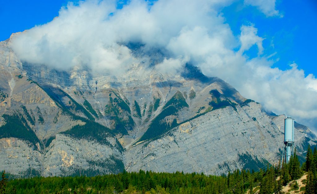
If you’re chasing a big Banff summit day with proper Rockies spice, this is it. The Cascade Mountain route serves up a long forest approach to the wildflower-ringed Cascade Amphitheatre, then transitions to scree, talus, and an airy ridge with massive views over the Bow Valley, Lake Minnewanka, and the town of Banff. It’s strenuous, exposed in places, and absolutely rewarding for experienced legs and heads.
This is an out-and-back, roughly 18 km/11.2 miles total with about 1,460 m/4,800 ft of gain. Start at the Mount Norquay ski area parking lot, walk past the day lodge down a service road, pass three chairlifts, cross Forty Mile Creek, and turn right. After about 2.5 km, take the signed Cascade Amphitheatre Trail and grind up steep forested switchbacks to the amphitheatre—a broad meadow and the end of the maintained trail. The scramble begins here: climb grassy slopes into rubble and scree, weave under sub-summits, hit a notorious false summit, then traverse an exposed saddle before the final scree push to the true summit at 2,998 m/9,836 ft. Allow 8–10 hours; 9 is typical for fit parties.
The amphitheatre is a natural intermission—quiet meadow, wildflowers in season, high cliffs wrapping the basin. Above, it turns to classic Canadian Rockies terrain: loose limestone/dolomite rubble, hanging cirque walls, and a skyline ridge. The summit panorama is the payoff: Bow Valley laid out, Lake Minnewanka shimmering, and distant heavyweights like Mt. Assiniboine and Mt. Temple on the horizon.
This is a serious day. Expect loose scree (especially the final kilometer), an exposed saddle after the false summit, and light hands-on scrambling in spots. Route-finding is straightforward going up in good visibility, but easy to botch on the way down—small deviations near the top can funnel you into cliffs. If there’s snow or ice lingering on the saddle or summit ridge, turn back; a slip here can be fatal. High winds amplify the risk.
Target late July through September when upper slopes are typically snow-free and weather is more stable. Start early to dodge afternoon build-ups and to bank time for careful route-finding and breaks at the amphitheatre. In shoulder seasons, lingering snow/ice turns the exposed sections into a no-go for hikers; only proceed if properly equipped and experienced.
Ideal for experienced hikers/scramblers comfortable with big elevation, loose footing, exposure, and disciplined navigation. If you’re new to the Rockies or want something friendlier, pick a warmup objective like Sulphur Mountain or Tunnel Mountain instead.
Overall: not for beginners, but for the capable and prepared, this is one of Banff’s most rewarding summit days.
Park at the Mount Norquay ski area lot. Walk past the day lodge down the service road, pass three chairlifts, cross Forty Mile Creek, then follow signs to the Cascade Amphitheatre Trail.
Serious exposure after the false summit, extensive loose scree, and complex descent navigation—small deviations can lead to cliffs. Snow or ice on the saddle or ridge can be deadly; turn back if present. Start early, bring proper gear, and retrace your route exactly.
Place
Place
Place
Place
Easy
Challenging
Challenging
Moderate

Parkwolf Tour Guide
