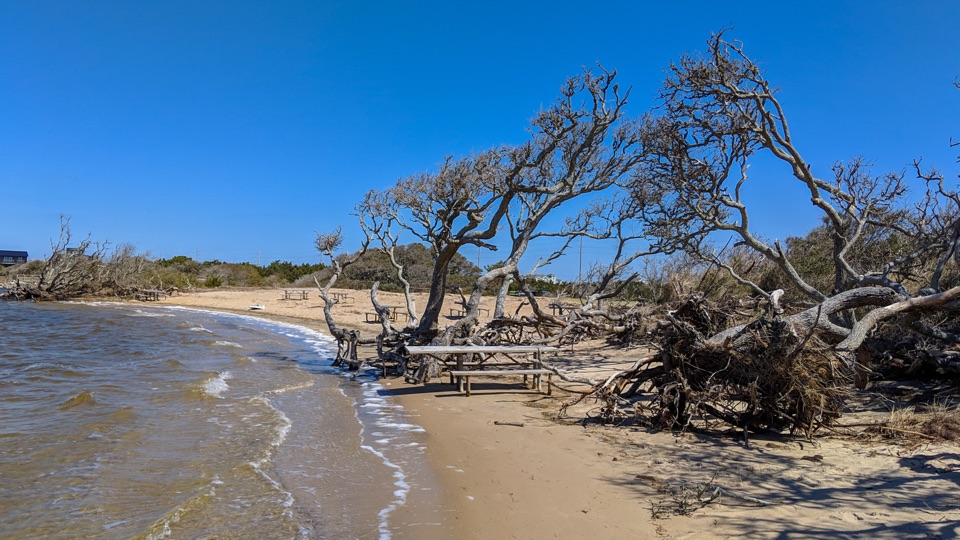
Salvo Day Use Area in Cape Hatteras National Seashore

Beach · Cape Hatteras National Seashore

Salvo Day Use Area

A sandy soundside break for paddling and a waterside picnic.

Photo: Wikimedia Commons
Type
Beach
Audio stories
3 nearby
  • Parking
  • Restrooms
  • Picnic tables
  • #13 of 26 sights

Hear the audio tour

Salvo Day Use Area

Overview

About Salvo Day Use Area

Why stop

  • The estuary setting adds a nature angle to a simple beach stop.

Map

Where it is

Loading the Cape Hatteras map
Full map
BeachSalvo Day Use Area35.53337, -75.47473
Keep this map with you offline in the Parkwolf app

Plan your stop

Before you go

Picnic setup and access

The access is at South Salvo, around Milepost 44 on NC-12. Paved parking serves the day-use area, and the National Park Service lists space for cars, boat trailers and buses or RVs. Picnic tables and metal grills make this a practical lunch stop if you bring food. The comfort station has two pit-style restrooms, two changing bays and an outdoor shower. The restrooms open seasonally, so they are not a year-round guarantee.

Beach access can change during protected bird and sea turtle nesting seasons. Follow posted closures before walking onto the sand. This is a useful stop for paddling, a picnic or a short soundside break; if you are looking for Atlantic surf, a long beach walk or services that are guaranteed in every season, choose another stop.


6 active Cape Hatteras alerts

  • ClosurePartial beach closures in front of Buxton VillageSections of beachfront in front of Buxton Village are temporarily closed. - The closure is due to threatened oceanfront structures and Dare County’s beach nourishment project.Official details
  • ClosurePartial beach closure in northern RodantheThe beach from the northern boundary of Rodanthe to the Rodanthe pier is closed to all access. - The closure is required because multiple threatened oceanfront structures pose risks to public safety.Official details
See all 6 alerts
A park ranger sits on a dash-mounted phone, talking, as Parkwolf’s Tour Guide plays “Army Cutworm Moths: A Grizzly Bear Buffet” on Grand Loop Road below Dunraven Pass in Yellowstone
Parkwolf Tour GuideThe highest, rockiest slopes around here are a summer buffet for grizzly bears.

Cape Hatteras Tour Guide

Your drive to Salvo Day Use Area, narrated.

Parkwolf is a GPS audio tour guide for Cape Hatteras National Seashore. As you drive, it chimes in with what’s ahead: hidden gems, upcoming stops, history, geology, and wildlife, right through your car’s speakers.

Recorded for this place

Salvo Day Use Area
0:00 / 0:28
“You're coming up on Salvo Day Use Area, a sandy access to Pamlico Sound rather than the Atlantic surf. It's a good pick for a picnic or a kayak launch: tables and grills face the water, with paved parking close by.”

Plays as you drive up to Salvo Day Use Area in the Parkwolf Cape Hatteras Tour Guide.

More stories near here in the app

  • The Turtle in the Marsh
  • The Blue Crab's Round Trip
  • A Lifeline Fired From Shore
  • The Post Office That Changed Yards
  • 67 audio storiesacross Cape Hatteras’s roads, triggered by GPS as you drive
  • Wildlife heatmapsfor Brown Pelican, Tamanend's Bottlenose Dolphin, Bald Eagle, and 13 more
  • Works offlinemaps, 11 trails, 35 places, and audio download before you lose signal
  • CarPlay readysimple controls built for the drive
★★★★★
“Fantastic app with many points of information… It’s great to just turn on while you’re driving and it gives you an audio tour of the national Park. We love it!!!!”
JMJamesApp Store review
Download Parkwolf on the App StoreGet Parkwolf on Google Play

4.7 from 8,600+ ratings

Guide

More about Salvo Day Use Area

A soundside beachSalvo Day Use Area is a sandy public beach and day-use access on the Pamlico Sound, on the…

Salvo Day Use Area is a sandy public beach and day-use access on the Pamlico Sound, on the sound side of Hatteras Island near Salvo. It is a different kind of stop from the seashore’s Atlantic beaches: this is a place to reach the sound, launch a small craft and settle in for a picnic. I’d choose it when you want time by the water without building the day around a major attraction.

Kayaks, kiteboards, windsurfers and stand-up paddleboards all suit this access. Families also use the sound for splashing and play. The draw is the broad water and sandy edge, with tables facing out toward Pamlico Sound.

A living soundThe Pamlico is an estuary where salt and fresh water mix.

The Pamlico is an estuary where salt and fresh water mix. Its marshes shelter eggs and young marine life as they hatch and grow, so the shoreline is part of a nursery as well as a recreation area. For a photo, work from the sound edge and include a curve of sand with open water beyond; the tree-shaded picnic tables help show how the beach fits into this developed day-use stop.

Wildlife

Wildlife in Cape Hatteras

All Cape Hatteras wildlife maps

Sighting maps show where each species has been reported across Cape Hatteras. Wildlife moves, so no sighting is guaranteed.

Parkwolf’s Cape Hatteras ranking

Top sights in Cape Hatteras

All 35 places
  1. 1Cape Hatteras LighthouseSight
  2. 2Bodie Island LighthouseSight
  3. 3Ocracoke LighthouseSight
  4. 4Cape PointBeach
  5. 5Coquina BeachBeach
  6. 6Bonner Bridge PierSight

Take Parkwolf to Cape Hatteras.

The audio tour guide for the drive, plus offline maps, trails, and wildlife heatmaps for when the signal drops.

4.7 from 8,600+ ratings

Download Parkwolf on the App StoreGet Parkwolf on Google Play