Chloride Cliff in Death Valley National Park

Sight · Death Valley National Park

Chloride Cliff

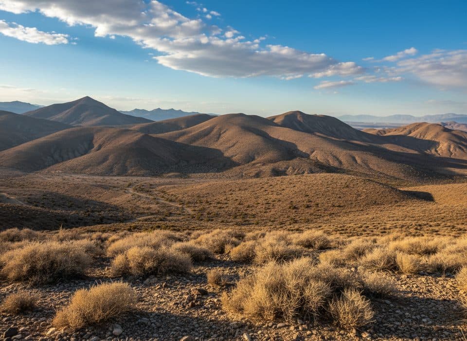
Remote cliff‑top panorama with ghost town relics and big-drop drama

Photo: National Park Service
Type
Sight
Nearest trail
2.4 mi
  • Scenic viewpoint
  • #26 of 74 sights
Parkwolf audio tour130 stories across Death Valley’s roads

Overview

About Chloride Cliff

Chloride Cliff is a high perch on the east side of the park, sitting around 5,279 feet and looming more than a vertical mile above the valley floor. It’s the kind of overlook that makes your stomach drop—in the best way—paired with the mining ruins of the nearby Chloride City ghost town for a one‑two punch of views and history.

Why stop

  • Huge cliff‑top panorama more than a vertical mile above the valley
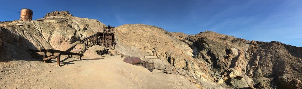
  • Adjacent ghost‑town relics: cabins, shafts, stamp mills, and a marked grave

Heads up

  • Rough, narrow 4WD road with steep drop‑offs and a loose final climb
  • No facilities—no water, restrooms, or formal parking
Off‑roaders, history buffs, photographers, and solitude seekers. If you want a paved pull‑off and a quick snap, this isn’t your stop. If you’re up for an adventurous approach and big, empty horizons, it’s a standout.
Parkwolf’s verdictWho Will Love It

Map

Where it is

Loading the Death Valley map
Full map
SightChloride Cliff36.69550, -116.87978
Keep this map with you offline in the Parkwolf app

Local know-how

Tips for visiting Chloride Cliff

  1. Use high‑clearance 4WD; the final stretch is steep, narrow, and rocky.

  2. Carry extra water, food, and a full‑size spare—there are no services.

  3. Admire mine ruins and open shafts from a distance; ground can be unstable.

  4. Plan for late‑day light; sunset brings the most dramatic views.

  5. In warm months, be snake‑aware around rocks and brush.

Plan your stop

Before you go

Best time to visit

Fall through spring is prime—cooler temps make the rough approach far more pleasant. Late afternoon into sunset flatters the landscape with raking light and usually gentler heat. This area sees little traffic, so crowds aren’t the issue; conditions are. Summer heat can still be serious even at elevation.

Getting There & Road Conditions

Access comes via Chloride Cliff Road on the park’s east side, ending near the Chloride City area and a short path to the lookout. The drive is adventurous: rocky, narrow, and shelfy with steep drop‑offs, and it gets rougher near the top. High‑clearance 4WD is the norm here; expect slow going and potential tire‑shredding rocks. The final climb is steep and loose, whether you drive or hike the last bit.

3 active Death Valley alerts

  • ClosurePark roads closed or hazardousPlan around multiple closed roads and use extra caution on damaged routes. - Paved roads: North Highway and Beatty Cut-off are closed due to flooding and debris from the October 22 storm.Official details
  • ClosureSaline Valley Lower Springs closed after wildfireLower Springs at Saline Valley Warm Springs remains closed after the September 15 wildfire; stay out because the fire left safety hazards, including potential hazardous chemicals.Official details
See all 3 alerts
A park ranger sits on a dash-mounted phone, talking, as Parkwolf’s Tour Guide plays “Army Cutworm Moths: A Grizzly Bear Buffet” on Grand Loop Road below Dunraven Pass in Yellowstone
Parkwolf Tour GuideThe highest, rockiest slopes around here are a summer buffet for grizzly bears.

Death Valley Tour Guide

Your drive to Chloride Cliff, narrated.

Parkwolf is a GPS audio tour guide for Death Valley National Park. As you drive, it chimes in with what’s ahead: hidden gems, upcoming stops, history, geology, and wildlife, right through your car’s speakers.

See the Death Valley audio tour

More stories near here in the app

  • Desert Pavement: The Park’s Fragile Stone Mosaic
  • Hells Gate: Your First Big Death Valley View
  • 130 audio storiesacross Death Valley’s roads, triggered by GPS as you drive
  • Wildlife heatmapsfor Bighorn Sheep, Desert Tortoise, Coyote, and 13 more
  • Works offlinemaps, 36 trails, 114 places, and audio download before you lose signal
  • CarPlay readysimple controls built for the drive
★★★★★
“Fantastic app with many points of information… It’s great to just turn on while you’re driving and it gives you an audio tour of the national Park. We love it!!!!”
JMJamesApp Store review
Download Parkwolf on the App StoreGet Parkwolf on Google Play

4.7 from 8,600+ ratings

Guide

More about Chloride Cliff

What You’ll SeeA sweeping, cliff‑edge panorama over Death Valley and across surrounding ranges.
  • A sweeping, cliff‑edge panorama over Death Valley and across surrounding ranges.
  • Mining history scattered nearby: old cabins, open shafts, the remains of three stamp mills, and the marked grave of miner James McKay. The townsite sits roughly half a mile from the cliff and a few hundred feet lower, making it easy to combine both in one visit.
Safety, Wildlife, and EtiquetteThis is a true backcountry, no‑services spot—there’s no water, restrooms, or developed parking.

This is a true backcountry, no‑services spot—there’s no water, restrooms, or developed parking. Bring plenty of water, food, layers, navigation, and a spare plus repair kit. Stay well back from the cliff edge, and give all mine ruins and open shafts a very wide berth—enjoy with your eyes and camera, not your feet. Panamint rattlesnakes are part of the neighborhood in warm months; watch where you step and place your hands.

ConnectivityDespite the remoteness, visitors report a solar‑powered cell repeater at the top that delivers…

Despite the remoteness, visitors report a solar‑powered cell repeater at the top that delivers strong reception for some carriers. Do not rely on service elsewhere along the route.

Wildlife

Wildlife in Death Valley

All Death Valley wildlife maps

Sighting maps show where each species has been reported across Death Valley. Wildlife moves, so no sighting is guaranteed.

Parkwolf’s Death Valley ranking

Top sights in Death Valley

All 114 places
  1. 1Badwater BasinSight
  2. 2Dante's ViewSight
  3. 3Mesquite Flat Sand DunesSight
  4. 4Zabriskie PointSight
  5. 5Golden CanyonSight
  6. 6Artists PaletteSight

Take Parkwolf to Death Valley.

The audio tour guide for the drive, plus offline maps, trails, and wildlife heatmaps for when the signal drops.

4.7 from 8,600+ ratings

Download Parkwolf on the App StoreGet Parkwolf on Google Play