Best time to visit
There’s no "hour" to target—access depends on tides, ice, weather, and tour timing. Crowds are generally a non-issue. Photographers should be ready for moody, contrasty scenes that suit overcast days as much as sun.

Sight · Glacier Bay National Park
Raw fjord with a colossal landslide scar and moody solitude
Overview
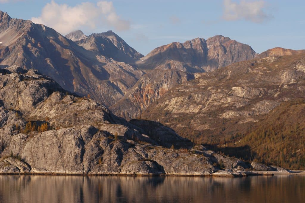
Tidal Inlet is a long, narrow fjord off the east side of Glacier Bay’s West Arm—raw, steep-walled, and strikingly austere. What grabs you first is the huge barren scar across the north slope, the aftermath of a historic landslide that makes the geology feel alive and in-your-face.
If you’re a geology nerd or you love stark, evolving landscapes, yes—Tidal Inlet is underrated. If you’re chasing glaciers, whales, or classic postcard views, you might prefer other stops and treat this as a cool drive-by when conditions allow.
 Parkwolf’s verdictIs it worth it?
Map
Local know-how
If you’re on a private boat, don’t linger under cliff faces or anchor close to shore; narrow inlets can amplify waves after slope failures.
Day tour inclusion is not guaranteed—it depends on timing, tides, ice, and weather.
Use the park’s bay map to orient yourself before you go [nps.gov](https://www.nps.gov/glba/planyourvisit/maps.htm).
Services are concentrated at Bartlett Cove; plan to be fully self-sufficient out on the bay [nps.gov](https://www.nps.gov/glba/learn/news/upload/Fairweather-Visitor-Guide-2025-508c-web.pdf).
Binoculars and a zoom lens help you appreciate the landslide scar from a safe distance.
Plan your stop

The highest, rockiest slopes around here are a summer buffet for grizzly bears.
Glacier Bay Tour Guide
Parkwolf is a GPS audio tour guide for Glacier Bay National Park. As you drive, it chimes in with what’s ahead: hidden gems, upcoming stops, history, geology, and wildlife, right through your car’s speakers.
“Fantastic app with many points of information… It’s great to just turn on while you’re driving and it gives you an audio tour of the national Park. We love it!!!!”


Guide
This inlet is a classic glacial fjord carved by ice, then rapidly reshaped as that ice retreated. The prominent landslide scar formed after deglaciation, with movement documented between 1892 and 1919. Researchers point to powerful turn-of-the-century earthquakes and the loss of glacier “buttressing” as triggers. That combo moved millions of cubic meters of slope—exact proof that Glacier Bay’s landscape is still very young and still changing.
The unstable slope above Tidal Inlet has been monitored for possible reactivation. A big failure here could generate fast, very large waves in the inlet and beyond. Narrow fjords can amplify those waves, and the disturbance can reverberate for hours. If you’re on a private boat, give cliff bases and obvious scarps wide berth and avoid anchoring close to shore.
You’re in broader Glacier Bay marine habitat, so you may spot passing marine mammals or seabirds. That said, the steep, unstable, sparsely vegetated slopes mean less of the lush shoreline life you see in greener coves; come here for geology first, wildlife second.
Keep your distance from unstable slopes, especially after seismic events. Stay alert to unusual wave activity and be ready to clear the shoreline quickly by boat.
Wildlife
 98 sightingsHumpback WhaleMost seen around 6 AMSighting map
 48 sightingsOrcaMost seen around 5 PMSighting map
 110 sightingsBrown BearMost seen around 7 PMSighting map
 312 sightingsSea OtterMost seen around 4 PMSighting map
 106 sightingsMountain GoatMost seen around 6 PMSighting map
 93 sightingsBald EagleMost seen around 5 PMSighting map
Sighting maps show where each species has been reported across Glacier Bay. Wildlife moves, so no sighting is guaranteed.
Keep exploring
Parkwolf’s Glacier Bay ranking
The audio tour guide for the drive, plus offline maps, trails, and wildlife heatmaps for when the signal drops.