Pros & cons
PROS
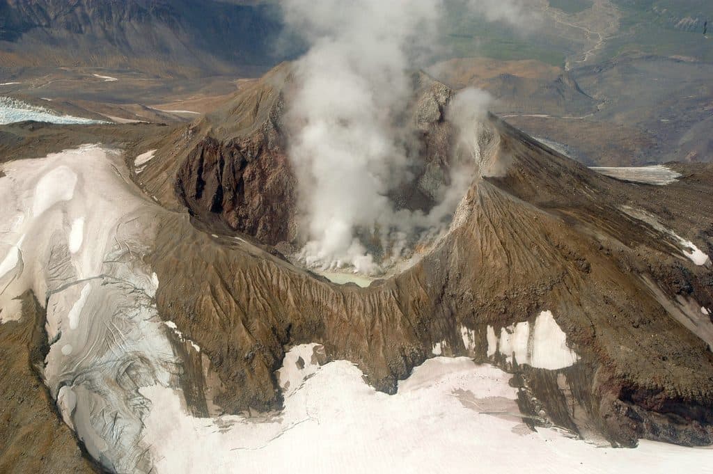
- Dramatic steaming crater and fumaroles on clear days
- Superb subject for scenic flightseeing over Katmai’s volcanoes
CONS
- No trails or facilities; entirely remote backcountry terrain
- Weather and low clouds often obscure views and cancel flights
Overview
Mount Martin is a remote, active volcanic cone within the Katmai volcanic cluster, perched on a high ridge west–southwest of Mount Mageik. It’s best known for persistent fumaroles and steam rather than recent eruptions, so think live geology without the fireworks. For most travelers, this is a see-it-from-the-air destination rather than a hike-in outing.
Geology and What You’ll See
At the summit sits a small crater (roughly 300 meters across) that’s breached on the southeast side. The crater hosts vigorous fumarolic activity and, at times, a short‑lived crater lake. A voluminous Holocene lava‑flow field spilled from a vent on the north flank, filling the upper Angle Creek valley—big flows, big volume, classic Katmai. Expect sulfur-stained rock and steaming vents when visibility cooperates.
How to Experience It
There’s no established trail to Mount Martin. Most visitors experience it by flightseeing—air taxis and operators based in King Salmon, Homer, Kodiak, or even Brooks Camp can overfly the Aleutian Range volcanoes when weather allows. If you’re an experienced backcountry traveler, reaching the area is a serious off‑trail expedition across glaciated/volcanic terrain and swift rivers. Plan full self‑sufficiency.
Logistics in Katmai
You can’t drive into Katmai. Typical access is by air into King Salmon, then by floatplane to Brooks Camp in summer. Infrastructure is concentrated at Brooks Camp; beyond that hub, don’t expect restrooms, parking lots, or signed trailheads. A seasonal bus runs the dirt road from Brooks Camp to the Valley of Ten Thousand Smokes for broader volcanic panoramas if flying isn’t in the cards.
Safety Essentials
Volcanic gases can be hazardous, crater rims are unstable, and snow or ash can hide voids—admire from a safe distance and don’t descend into the crater. This is deep bear country: manage food and odors, maintain space, and follow park guidance. Check current volcano status and any alerts before committing to a trip.
Best Time to Visit
June through September offers the best weather windows, but storms, low clouds, and poor visibility can happen any time. Build buffer days into flightseeing plans, and be ready to pivot to broader regional views (like the Valley of Ten Thousand Smokes) if clouds sit on the high peaks.

Where it is
58.1691, -155.3565Tips for Mount Martin
- 01If you mainly want to see it, book a scenic flight and plan weather buffer days.
- 02Backcountry attempts demand off‑trail navigation, river crossings, and serious bear‑safety planning.
- 03Do not approach or descend toward the crater—fumarolic gases and unstable rims are dangerous.
- 04When flights can’t go, the Valley of Ten Thousand Smokes bus/hike offers wider volcanic views.
Near Mount Martin
All places →All trails →
4.2 mi awayMount MageikRemote, glacier-clad volcano best seen from the Valley Overlook
9.8 mi awayNovarupta1912 eruption vent capped by a rhyolite dome in ash desert
9.8 mi awayBaked MountainRemote volcanic ridge above the Valley of Ten Thousand Smokes
10.3 mi awayTrident VolcanoRemote three-peaked volcano best by VTS bus or flightseeing
30.9 mi awayBrooks River Elevated BoardwalkElevated stroll to world-class bear viewing on the Brooks RiverEasy · 2.2 mi · 1 hr
Brooks Falls TrailShort, flat walk to world-class brown bear viewing platformsEasy · 1.2 mi · 30 min
Dumpling Mountain TrailBig Brooks Camp views, real tundra, and real bear countryChallenging · 8 mi · 5.3 hr
Cultural Site TrailA flat, 0.5-mile walk to a reconstructed Alutiiq home by Brooks River.Easy · 0.5 mi · 15 min