Ireteba Wash Route in Lake Mead National Recreation Area

Lake Mead National Recreation Area, AZ · NV

Ireteba Wash Route

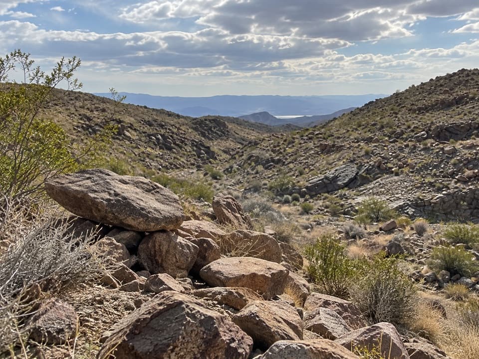
A sandy wash leads to a rock perch above Lake Mohave.

Length
3.7mi
Time
3.5hr
Elev. change
502ft
Difficulty
Moderate
  • No dogs
  • High point 2,405 ft
Parkwolf audio tour153 stories across Lake Mead’s roads

Overview

About Ireteba Wash Route

Why go

  • Sitting Rock frames views from Ireteba Peak to Lake Mohave.
  • The old road gives way to a narrow wash and rock outcrop.

Heads up

  • Loose sand and fading tread make routefinding slow.
  • Remote dirt-road access and an unverified private-land passage need checking.

Map & elevation

The route

Loading the Lake Mead map
Full map
Elevation1,903–2,405 ft
TrailheadIreteba Wash Trailhead35.57412, -114.77089
Keep this map with you offline in the Parkwolf app

Plan your hike

Before you go

Parking

From Searchlight, take Cottonwood Cove Road east about 7.8 miles to Rockefeller Mine Road. Follow it about 10.5 miles to a fork, turn right onto the smaller road, then continue 0.13 mile to a broad wash at the road end. Parking is informal and unmarked. The dirt approach is rough and sandy; high clearance is recommended and four-wheel drive is safer in soft sand. There are no services along the road, and a Lake Mead recreation pass is required.

Safety

The initial 0.23 mile is described as crossing a private parcel, and public right-of-way is unverified; confirm legal access with the land managers before hiking. The route is remote and mostly unmarked, with loose sand and no water. Avoid the wash when storms threaten because flash floods can form in dry channels. Pets are prohibited in Ireteba Peaks Wilderness.

4 active Lake Mead alerts

  • CautionHarmful algae bloom at Nelson’s Landing and Cottonwood CoveMentions Cottonwood Cove, referenced in this guideA harmful algae bloom has been confirmed in recent samples from Nelson’s Landing and Cottonwood Cove; avoid contact with water where algae is visible.Official details
  • CautionArizona Hot Springs bacteria advisoryLimit body contact with Arizona Hot Springs water: fecal bacteria in samples frequently reach high levels and can transmit human diseases.Official details
See all 4 alerts
A park ranger sits on a dash-mounted phone, talking, as Parkwolf’s Tour Guide plays “Army Cutworm Moths: A Grizzly Bear Buffet” on Grand Loop Road below Dunraven Pass in Yellowstone
Parkwolf Tour GuideThe highest, rockiest slopes around here are a summer buffet for grizzly bears.

Lake Mead Tour Guide

Your drive to Ireteba Wash Route, narrated.

Parkwolf is a GPS audio tour guide for Lake Mead National Recreation Area. As you drive, it chimes in with what’s ahead: hidden gems, upcoming stops, history, geology, and wildlife, right through your car’s speakers.

See the Lake Mead audio tour
  • 153 audio storiesacross Lake Mead’s roads, triggered by GPS as you drive
  • Wildlife heatmapsfor Bighorn Sheep, Burro, Bald Eagle, and 13 more
  • Works offlinemaps, 42 trails, 70 places, and audio download before you lose signal
  • CarPlay readysimple controls built for the drive
★★★★★
“Fantastic app with many points of information… It’s great to just turn on while you’re driving and it gives you an audio tour of the national Park. We love it!!!!”
JMJamesApp Store review
Download Parkwolf on the App StoreGet Parkwolf on Google Play

4.7 from 8,600+ ratings

Trail guide

Hiking Ireteba Wash Route

A sandy wash to Sitting RockIreteba Wash Route is an informal out-and-back from the end of Rockefeller Mine Road to Sitting…

Ireteba Wash Route is an informal out-and-back from the end of Rockefeller Mine Road to Sitting Rock. Plan on 3.68 miles round trip, about 1.84 miles each way, and roughly 3–4 hours. The route climbs about 500 feet to a flat boulder perched above the wash, with views toward Lake Mohave and Ireteba Peak. Much of the walk follows loose sand or a fading old road rather than a marked trail, so it suits hikers comfortable navigating remote desert terrain.

Access and planningThe start is an unmarked broad wash at the end of the smaller road off Rockefeller Mine Road.

The start is an unmarked broad wash at the end of the smaller road off Rockefeller Mine Road. The final drive is rough, sandy and remote, with no services; high clearance is recommended, and four-wheel drive is safer when the sand is soft. A Lake Mead recreation pass is required, but no wilderness backcountry permit is required. Carry all your water and plan around desert heat; shade is occasional and mostly where the wash narrows.

The initial 0.23 mile is described as crossing a private parcel before a survey monument marks the return to wilderness. Public right-of-way for that short section has not been verified. Confirm legal access with the land managers before setting out. Pets are prohibited in Ireteba Peaks Wilderness.

Follow the road into the washWalk north past the wooden barriers.

Walk north past the wooden barriers. The old mining road climbs gradually to a low ridge, then crosses a wash beside a dark hill; around 0.4 mile its sandy tread briefly disappears before reappearing near the hill. Once the road fades for good, follow the main wash upstream. At the fork about 1.19 miles out, stay right; the left branch leads toward a mining prospect. The wash gets narrower and sandier, with some shade from its walls. At about 1.78 miles, pass a low pour-over, continue roughly 0.06 mile, then climb the north bank to Sitting Rock. Turn around and return the same way.

Sitting Rock and the surrounding wildernessThe route ends at a broad, flat rock on an outcrop.

The route ends at a broad, flat rock on an outcrop. From there, the view reaches southeast toward Lake Mohave and west toward Ireteba Peak. For a useful photo, keep the rock in the foreground and include the wash running toward the distant water. Teddy-bear cholla and California barrel cactus grow along the wash and rocky slopes. The wider wilderness takes its name from Ireteba, a Mohave leader who guided Lt. J.C. Ives; its surrounding ridges include volcanic rock and granite outcrops.

Wildlife

Wildlife in Lake Mead

All Lake Mead wildlife maps

Sighting maps show where each species has been reported across Lake Mead. Wildlife moves, so no sighting is guaranteed.

Parkwolf’s Lake Mead ranking

Top-rated trails in Lake Mead

All 42 trails
  1. 1Historic Railroad TrailEasy · 7.5 mi
  2. 2Anniversary Narrows TrailModerate · 5.8 mi
  3. 3Liberty Bell Arch TrailChallenging · 5.5 mi
  4. 4Arizona Hot Spring TrailChallenging · 5 mi
  5. 5Owl Canyon TrailModerate · 2.2 mi
  6. 6Fortification Hill TrailChallenging · 4 mi

Take Parkwolf to Lake Mead.

The audio tour guide for the drive, plus offline maps, trails, and wildlife heatmaps for when the signal drops.

4.7 from 8,600+ ratings

Download Parkwolf on the App StoreGet Parkwolf on Google Play