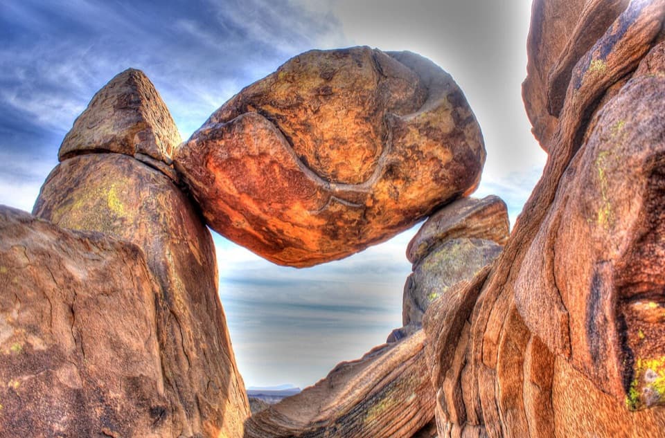
Balanced Rock in Big Bend National Park

#8 of 45 sights in Big Bend

Sight · Big Bend National Park

Balanced Rock

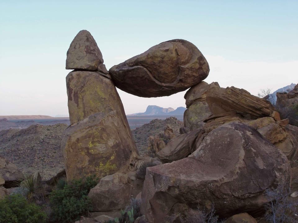
A boulder spans two stone pillars in a field of desert rocks.

Photo: Public Domain
Type
Sight
Nearest trail
0.9 mi
  • Trailhead
  • Parking
  • Scenic viewpoint

Hear the audio tour

Balanced Rock via Grapevine Hills

Overview

About Balanced Rock

Why stop

  • An unmistakable rock formation surrounded by wide desert views.

Heads up

  • Rough high-clearance access, no shade, and a steep rocky finish.
Balanced Rock is a broad boulder bridging two stone supports in a field of rounded rocks in Grapevine Hills. You reach it on a 2.2-mile round-trip walk, not from a roadside pullout. Allow one to two hours for the hike. The odd formation and open desert views make it a good choice if you want a close look at Big Bend's rock country and are comfortable with a steep, rocky finish.
Parkwolf’s verdictA rock worth the short hike

Map

Where it is

Loading the Big Bend map
Full map
SightBalanced Rock29.39893, -103.20291
Keep this map with you offline in the Parkwolf app

Plan your stop

Before you go

2 active Big Bend alerts

  • ClosureWeather-related road closuresDo not use these closed roads; NPS lists the closures as in effect until further notice.Official details
  • InfoBoquillas Crossing schedule changeBoquillas Crossing is open Friday through Monday, 9:00 a.m.–4:00 p.m.; NPS says it will not change to winter hours at this time. Check current park conditions before planning a crossing.Official details

Big Bend alerts
A park ranger sits on a dash-mounted phone, talking, as Parkwolf’s Tour Guide plays “Army Cutworm Moths: A Grizzly Bear Buffet” on Grand Loop Road below Dunraven Pass in Yellowstone
Parkwolf Tour GuideThe highest, rockiest slopes around here are a summer buffet for grizzly bears.

Big Bend Tour Guide

Your drive to Balanced Rock, narrated.

Parkwolf is a GPS audio tour guide for Big Bend National Park. As you drive, it chimes in with what’s ahead: hidden gems, upcoming stops, history, geology, and wildlife, right through your car’s speakers.

See the Big Bend audio tour

Recorded for this place

Balanced Rock via Grapevine Hills
0:00 / 0:27
“You're approaching the Grapevine Hills Road turnoff for Balanced Rock, a huge boulder spanning two stone supports.”

Plays as you drive up to Balanced Rock in the Parkwolf Big Bend Tour Guide.

More stories near here in the app

  • Nina Hannold's Gravesite
  • Ocotillo’s Quick Change
  • A Thin Coat of Desert Varnish
  • Give the Night Sky Some Time
  • 110 audio storiesacross Big Bend’s roads, triggered by GPS as you drive
  • Wildlife heatmapsfor Black Bear, Collared Peccary, White-tailed Deer, and 13 more
  • Works offlinemaps, 45 trails, 64 places, and audio download before you lose signal
  • CarPlay readysimple controls built for the drive
★★★★★
“Fantastic app with many points of information… It’s great to just turn on while you’re driving and it gives you an audio tour of the national Park. We love it!!!!”
JMJamesApp Store review
Download Parkwolf on the App StoreGet Parkwolf on Google Play

4.7 from 8,600+ ratings

Guide

More about Balanced Rock

Getting to the trailheadThe Grapevine Hills Road junction is 3.

The Grapevine Hills Road junction is 3.3 miles west of Panther Junction; the trailhead is another 6.5 miles down the rough dirt road. Take a sturdy high-clearance vehicle. Passenger cars, minivans, and RVs aren't suitable for this road. The trailhead has a dirt lot for about ten vehicles and an information board, so parking is limited.

The walk gets rough at the endThe trail follows a gravel wash for most of the way. Its first 0.

The trail follows a gravel wash for most of the way. Its first 0.75 mile is relatively easy, then the last quarter-mile climbs steeply over rough bedrock and boulders. The total elevation change is only about 80 feet, but that final scramble is the part that catches people out.

There is no shade anywhere along the trail. Follow the park's desert-hiking guidance: plan on a liter of water per person for each hiking hour and protect yourself from the sun.

Follow the arrows through the rocksDirectional arrows lead through the boulder field to the formation.

Directional arrows lead through the boulder field to the formation. Keep an eye out for them once you reach the rocks; it is easy to get drawn toward the other giant boulders and lose the route. Stay on the established path rather than scrambling onto unmarked terrain.

How the formation took shapeBalanced Rock sits in Grapevine Hills, an exposed laccolith: a mushroom-shaped igneous…

Balanced Rock sits in Grapevine Hills, an exposed laccolith: a mushroom-shaped igneous intrusion that pushed up beneath older rock and domed the layers above it. Erosion later exposed the intrusion and its many large, rounded boulders. The shape here is the result of that larger geologic story, not a single rock perched by chance.

Frame the openingAt the marked destination, look for a view through the gap beneath the spanning boulder, with…

At the marked destination, look for a view through the gap beneath the spanning boulder, with the desert hills beyond. That angle shows the rock's unusual support and gives the surrounding landscape some scale. The trail itself is exposed, so plan the timing around the heat rather than waiting for a cooler moment once you're already out there.

Wildlife

Wildlife in Big Bend

All Big Bend wildlife maps

Sighting maps show where each species has been reported across Big Bend. Wildlife moves, so no sighting is guaranteed.

Parkwolf’s Big Bend ranking

Top sights in Big Bend

All 64 places
  1. 1Santa Elena CanyonSight
  2. 2Sotol VistaSight
  3. 3Fossil Discovery ExhibitSight
  4. 4Window ViewSight
  5. 5Boquillas CanyonSight
  6. 6Langford Hot SpringsSight

Take Parkwolf to Big Bend.

The audio tour guide for the drive, plus offline maps, trails, and wildlife heatmaps for when the signal drops.

4.7 from 8,600+ ratings

Download Parkwolf on the App StoreGet Parkwolf on Google Play