Shark Valley Tram Road Loop in Everglades National Park

#5 of 19 trails in Everglades

Everglades National Park, FL

Shark Valley Tram Road Loop

Fifteen flat miles through sawgrass, shared with trams and bikes.

Photo: National Park Service
Length
15mi
Time
6.5hr
Elevation
Flat
Difficulty
Moderate
  • Loop
  • No dogs
  • High point 10 ft

Hear the audio tour

Shark Valley: Choose the Tram or a Bike

Overview

About Shark Valley Tram Road Loop

Why go

  • A wide, open look at the sawgrass marsh across the full loop.
  • The tower, hammock path and water fountain give the route a useful midpoint break.

Heads up

  • Fifteen miles in very little shade is a full-day commitment.
  • Tram vehicles and cyclists share the pavement.

Map & elevation

The route

Loading the Everglades map
Full map
Elevation7–10 ft
TrailheadShark Valley Visitor Center25.75701, -80.76542
Keep this map with you offline in the Parkwolf app

Plan your hike

Before you go

Parking

Start at Shark Valley Visitor Center off U.S. 41 (Tamiami Trail); the paved loop begins behind the center. The lot has auto and bus/RV parking, restrooms and drinking water. Parking can fill during the busy November-through-April season, and entry may be metered one car in for each car out. A park entrance pass is required.

Safety

The long paved route has very little shade. Tram vehicles and bicycles share the road. Refill at the visitor center and at the tower about seven miles in.

4 active Everglades alerts

  • CautionRoadwork delays on U.S. 41/Tamiami TrailMentions Tamiami Trail, referenced in this guideOngoing roadwork along the park’s northern boundary on U.S. Highway 41/Tamiami Trail may cause delays of up to 15 minutes.Official details
  • ClosureEast Everglades Day Use Area closedThe East Everglades Day Use Area is closed to all public use from SW 168 Street westbound to SW 237 Avenue, including the entire roadway of SW 237 Avenue.Official details
See all 4 alerts
A park ranger sits on a dash-mounted phone, talking, as Parkwolf’s Tour Guide plays “Army Cutworm Moths: A Grizzly Bear Buffet” on Grand Loop Road below Dunraven Pass in Yellowstone
Parkwolf Tour GuideThe highest, rockiest slopes around here are a summer buffet for grizzly bears.

Everglades Tour Guide

Your drive to Shark Valley Tram Road Loop, narrated.

Parkwolf is a GPS audio tour guide for Everglades National Park. As you drive, it chimes in with what’s ahead: hidden gems, upcoming stops, history, geology, and wildlife, right through your car’s speakers.

See the Everglades audio tour

Recorded for this trailhead

Shark Valley: Choose the Tram or a Bike
0:00 / 0:34
“You're coming up on the Shark Valley entrance, where private cars stay at the parking lot.”

Plays as you drive up to this trailhead in the Parkwolf Everglades Tour Guide.

More stories near here in the app

  • Eight Pumas from Texas
  • An Alligator Mother Listens
  • When Sea Breezes Build Storms
  • The Egret That Stirs Its Supper
  • 62 audio storiesacross Everglades’s roads, triggered by GPS as you drive
  • Wildlife heatmapsfor Mountain Lion, West Indian Manatee, Alligator, and 13 more
  • Works offlinemaps, 19 trails, 33 places, and audio download before you lose signal
  • CarPlay readysimple controls built for the drive
★★★★★
“Fantastic app with many points of information… It’s great to just turn on while you’re driving and it gives you an audio tour of the national Park. We love it!!!!”
JMJamesApp Store review
Download Parkwolf on the App StoreGet Parkwolf on Google Play

4.7 from 8,600+ ratings

Trail guide

Hiking Shark Valley Tram Road Loop

A long walk, not a quick trailThe Shark Valley Tram Road Loop is a 15-mile paved circuit through the sawgrass marsh of…

The Shark Valley Tram Road Loop is a 15-mile paved circuit through the sawgrass marsh of Everglades National Park, starting behind Shark Valley Visitor Center and reaching the observation tower about halfway around. The loop is essentially flat, but the distance makes this a full day on foot. I’d choose it if you want a long, open look at the Everglades and don’t mind sharing the pavement. If you came for a short nature walk, take one of the separate boardwalk or hammock trails instead. The 15 miles is the whole loop, not 15 miles each way. Allow about six to seven hours with time for the tower and wildlife stops.

A road across the marshThe route follows a paved service road with no meaningful climb.

The route follows a paved service road with no meaningful climb. Sawgrass stretches across the open freshwater marsh, with tree islands adding darker patches to the horizon. Tram vehicles and bicycles use the same road, so expect a working visitor route rather than a quiet footpath. There is very little shade. That exposure and the long distance are the real challenge; the ground itself is flat and easy to follow.

Pause at the observation towerAbout seven miles from the visitor center, the road reaches Shark Valley Observation Tower.

About seven miles from the visitor center, the road reaches Shark Valley Observation Tower. The tower looks across the broad marsh, and a short tropical hardwood hammock path branches below it. A water fountain is here, roughly halfway through the loop. Fill up before setting out and take a real break at the tower before finishing the circuit. For a photo, keep some of the near marsh below the horizon; that foreground helps show the breadth of the view.

There is a bit of fire lookout history here, too. The Seven Mile Fire Tower was used to spot fires across the Everglades; the current observation tower replaced it in 1966. The tower is the main pause on the walk, but it does not shorten the loop. Continuing the road is what brings you back to the visitor center.

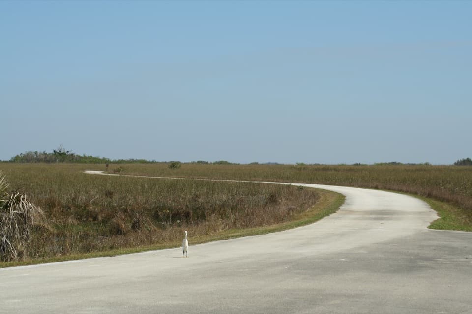
Watch the sawgrass edgesThis is freshwater marsh country, a huge river of grass dotted with tree islands.

This is freshwater marsh country, a huge river of grass dotted with tree islands. Alligators, herons, egrets, deer, turtles and snail kites are among the wildlife associated with the route. The dry winter months are the park’s strongest season for abundant sightings, as water levels change through the year. These are wild animals, so sightings are never guaranteed. Keep to the road and give wildlife space.

Getting startedStart at Shark Valley Visitor Center off U.S. 41, also called Tamiami Trail.

Start at Shark Valley Visitor Center off U.S. 41, also called Tamiami Trail. Restrooms and drinking water are available there, and the concession offers tram tours, bike rentals, snacks and soft drinks. It does not sell meals, so eat before you go or bring food for the walk. A park entrance pass is required. Parking can fill during the busy November-through-April season, and staff may meter entry so one car comes in as another leaves. Pets are not allowed on park trails.

Wildlife

Wildlife in Everglades

All Everglades wildlife maps

Sighting maps show where each species has been reported across Everglades. Wildlife moves, so no sighting is guaranteed.

Parkwolf’s Everglades ranking

Top-rated trails in Everglades

All 19 trails
  1. 1Anhinga TrailEasy · 0.8 mi
  2. 2Mahogany Hammock TrailEasy · 0.5 mi
  3. 3Pa-hay-okee Overlook TrailEasy · 0.2 mi
  4. 4Gumbo Limbo TrailEasy · 0.4 mi
  5. 6Bobcat Boardwalk TrailEasy · 0.4 mi
  6. 7West Lake TrailEasy · 0.5 mi

Take Parkwolf to Everglades.

The audio tour guide for the drive, plus offline maps, trails, and wildlife heatmaps for when the signal drops.

4.7 from 8,600+ ratings

Download Parkwolf on the App StoreGet Parkwolf on Google Play