Parking
Start behind the Richard Proenneke cabin on Upper Twin Lake’s south shore. There is no road access; summer visitors arrive by floatplane unless hiking in from elsewhere in the park.
#4 of 5 trails in Lake Clark
Lake Clark National Park, AK
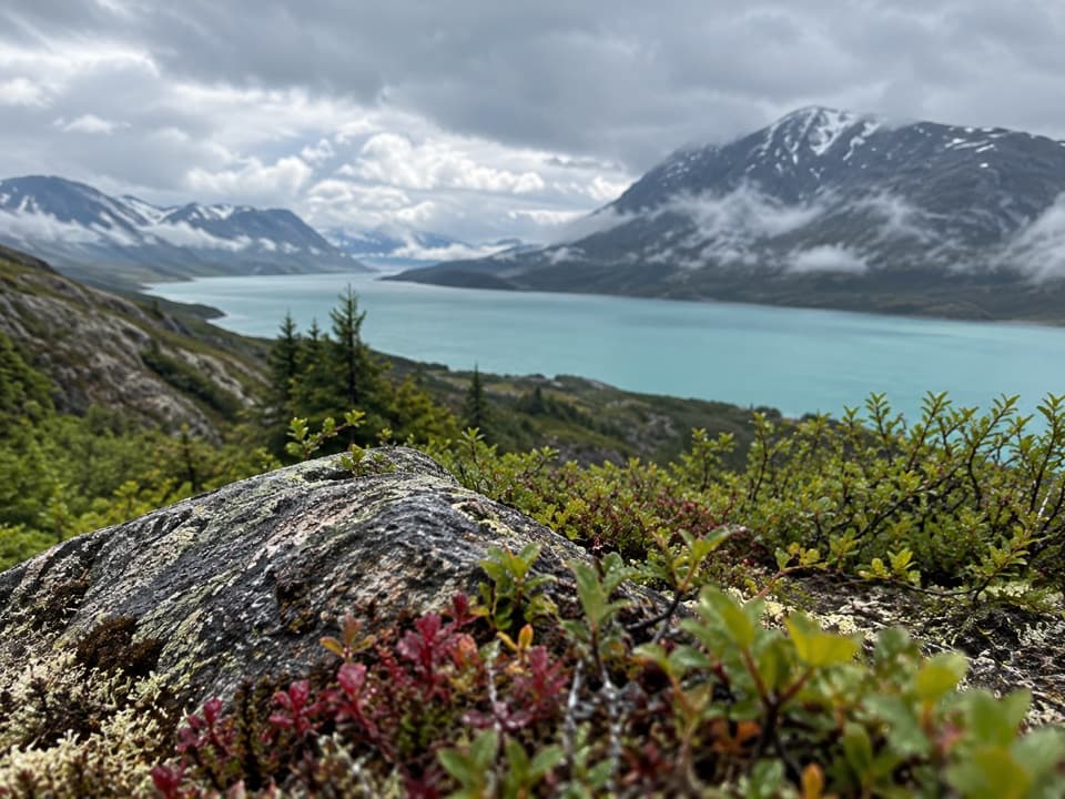
A short climb to a balanced rock above Upper Twin Lake.
Overview
Map & elevation
Plan your hike

The highest, rockiest slopes around here are a summer buffet for grizzly bears.
Lake Clark Tour Guide
Parkwolf is a GPS audio tour guide for Lake Clark National Park. As you drive, it chimes in with what’s ahead: hidden gems, upcoming stops, history, geology, and wildlife, right through your car’s speakers.
See the Lake Clark audio tour“Fantastic app with many points of information… It’s great to just turn on while you’re driving and it gives you an audio tour of the national Park. We love it!!!!”


Trail guide
Teetering Rock Trail is an out-and-back from the Richard Proenneke cabin to a balanced boulder above Hope Creek, with a wide view over Upper Twin Lake. The mapped way is about 0.8 mile each way, so this record treats it as a 1.6-mile round trip with about 425 feet of climb. Published figures vary from 1 to 1.8 miles, and the upper end is not pinned consistently, so use the worn path to the rock as your cue instead of treating mileage as exact. Allow about 1½ hours. The distance is short, but the climb is noticeably steep. I’d add it if you’re already at the cabin; reaching this remote start takes far more planning than the hike.
Start behind the cabin and follow the path as it winds through spruce and brush beside Hope Creek. The creek runs over small boulders, and you can hear it on the climb. The route rises out of the trees; brush isn’t fully cleared along the edges. This is an unmaintained trail, so follow the worn line instead of cutting fresh tracks through fragile tundra.
A balanced boulder marks the end and opens a broad view of Upper Twin Lake. The pale turquoise water and distant mountains are the payoff. Take your time at the rock: a view that keeps the boulder and lake together shows why this is a named destination.
The trailhead is at the remote cabin site on the lake’s south shore, with no road access. Summer visitors arrive by floatplane unless they backpack in from elsewhere in the park. Be ready to stay overnight if weather delays your return. A pit toilet is on a separate fork behind the cabin; take the left branch. The cabin is a National Historic Landmark connected to Sam Keith’s One Man’s Wilderness: An Alaskan Odyssey.
Wildlife
 142 sightingsBrown BearMost seen around 8 AMSighting map
 11 sightingsBald EagleMost seen around 6 PMSighting map
 13 sightingsCommon MerganserMost seen around 8 AMSighting map
Sighting maps show where each species has been reported across Lake Clark. Wildlife moves, so no sighting is guaranteed.
Keep exploring
 Sight · At the trailheadRichard Proenneke CabinA 12-by-16 cabin makes wilderness living feel immediate.
 Campground · 0.2 mi awayHope Creek CampsiteA backcountry camp across Hope Creek from Proenneke's cabin.
 Lodging · 1.2 mi awayWindsong Wilderness RetreatA cabin base across Twin Lake from Proenneke's historic cabin.
 Ranger station · 7.5 mi awayLower Twin Lake Ranger StationA remote ranger post on Lake Clark’s Twin Lakes crossing.
Parkwolf’s Lake Clark ranking

The audio tour guide for the drive, plus offline maps, trails, and wildlife heatmaps for when the signal drops.


