Bonelli Bay Trail in Lake Mead National Recreation Area

Lake Mead National Recreation Area, AZ · NV

Bonelli Bay Trail

A remote road walk to Bonelli Bay’s changing Lake Mead shoreline.

Photo: Wikimedia Commons
Length
5.2mi
Time
3hr
Elev. change
440ft
Difficulty
Moderate
  • Dogs allowed
  • High point 1,568 ft
Parkwolf audio tour153 stories across Lake Mead’s roads

Overview

About Bonelli Bay Trail

Why go

  • Open views over Lake Mead’s eastern arm.
  • A backcountry approach to the distinctive Bonelli Bay.

Heads up

  • The route follows unpaved roads rather than maintained trail tread.
  • The rough, exposed approach makes this a bigger outing than a quick shore walk.

Map & elevation

The route

Loading the Lake Mead map
Full map
Elevation1,129–1,568 ft
TrailheadBonelli Landing Road turnoff36.05696, -114.50805
Keep this map with you offline in the Parkwolf app

Plan your hike

Before you go

Parking

Start where the mapped Bay track leaves Bonelli Landing Road. No developed trailhead or formal parking lot was identified; use only a safe roadside pullout that does not block the route. The main approach is dirt and the marked bay branch is rougher; high clearance is recommended for drivers on that final leg.

Safety

Open desert exposure, no drinking-water stop verified along the route, and summer temperatures that can exceed 100°F. Heavy rain can create flash-flood hazards in nearby washes. If driving, stay on the park’s yellow-arrow-marked backcountry roads; unmarked roads are prohibited.

4 active Lake Mead alerts

  • CautionHarmful algae bloom at Nelson’s Landing and Cottonwood CoveA harmful algae bloom has been confirmed in recent samples from Nelson’s Landing and Cottonwood Cove; avoid contact with water where algae is visible.Official details
  • CautionArizona Hot Springs bacteria advisoryLimit body contact with Arizona Hot Springs water: fecal bacteria in samples frequently reach high levels and can transmit human diseases.Official details
See all 4 alerts
A park ranger sits on a dash-mounted phone, talking, as Parkwolf’s Tour Guide plays “Army Cutworm Moths: A Grizzly Bear Buffet” on Grand Loop Road below Dunraven Pass in Yellowstone
Parkwolf Tour GuideThe highest, rockiest slopes around here are a summer buffet for grizzly bears.

Lake Mead Tour Guide

Your drive to Bonelli Bay Trail, narrated.

Parkwolf is a GPS audio tour guide for Lake Mead National Recreation Area. As you drive, it chimes in with what’s ahead: hidden gems, upcoming stops, history, geology, and wildlife, right through your car’s speakers.

See the Lake Mead audio tour

More stories near here in the app

  • The Grebes That Run on Water
  • A Bat That Listens for Footsteps
  • A Mesquite's Two Root Systems
  • A Cactus Works the Night Shift
  • 153 audio storiesacross Lake Mead’s roads, triggered by GPS as you drive
  • Wildlife heatmapsfor Bighorn Sheep, Burro, Bald Eagle, and 13 more
  • Works offlinemaps, 42 trails, 70 places, and audio download before you lose signal
  • CarPlay readysimple controls built for the drive
★★★★★
“Fantastic app with many points of information… It’s great to just turn on while you’re driving and it gives you an audio tour of the national Park. We love it!!!!”
JMJamesApp Store review
Download Parkwolf on the App StoreGet Parkwolf on Google Play

4.7 from 8,600+ ratings

Trail guide

Hiking Bonelli Bay Trail

Is this your kind of walk?Bonelli Bay Trail is a 5.

Bonelli Bay Trail is a 5.23-mile out-and-back on unpaved backcountry roads, from Bonelli Landing Road to the Bonelli Bay access area and back. The mapped corridor is 2.63 miles each way. It’s a remote road walk, not a built footpath; choose it for the open desert approach and broad Lake Mead views, and skip it if you want a maintained trail or an easy lakeshore stroll. Allow about three hours.

The road inThe line starts where the Bay track leaves Bonelli Landing Road and follows connected dirt…

The line starts where the Bay track leaves Bonelli Landing Road and follows connected dirt roads to the bay area. It drops roughly 440 feet toward the far end, so the return is an uphill walk over the same ground. The park marks approved backcountry roads with yellow arrows; driving on roads without those markers is prohibited. No developed trailhead or formal lot is documented. The marked dirt branch toward the bay is rougher than the main road, and high clearance is recommended for drivers.

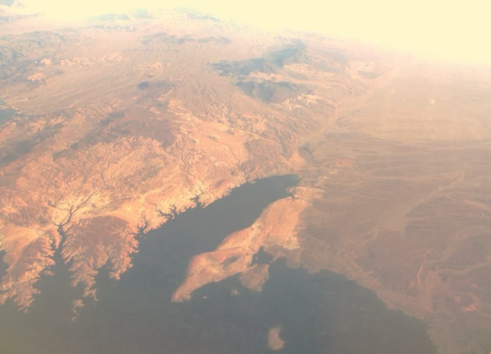
Waterline and viewsThe far end reaches the Bonelli Bay access area on Lake Mead’s Arizona side.

The far end reaches the Bonelli Bay access area on Lake Mead’s Arizona side. The bay has shrunk as lake levels have fallen, so expect the shoreline to sit differently from older maps and photos. High ground around the bay opens wide views over the eastern arm of the reservoir; that open, changing landscape is the reason to make the long approach.

Heat, storms and dogsThis is exposed desert ground, with no drinking-water stop verified along the route.

This is exposed desert ground, with no drinking-water stop verified along the route. Summer temperatures can exceed 100°F. Heavy rain can turn nearby washes into flash-flood hazards, so leave this route for a clear-weather day. Dogs are allowed in the recreation area; keep them on a leash no longer than six feet.

Wildlife

Wildlife in Lake Mead

All Lake Mead wildlife maps

Sighting maps show where each species has been reported across Lake Mead. Wildlife moves, so no sighting is guaranteed.

Parkwolf’s Lake Mead ranking

Top-rated trails in Lake Mead

All 42 trails
  1. 1Historic Railroad TrailEasy · 7.5 mi
  2. 2Anniversary Narrows TrailModerate · 5.8 mi
  3. 3Liberty Bell Arch TrailChallenging · 5.5 mi
  4. 4Arizona Hot Spring TrailChallenging · 5 mi
  5. 5Owl Canyon TrailModerate · 2.2 mi
  6. 6Fortification Hill TrailChallenging · 4 mi

Take Parkwolf to Lake Mead.

The audio tour guide for the drive, plus offline maps, trails, and wildlife heatmaps for when the signal drops.

4.7 from 8,600+ ratings

Download Parkwolf on the App StoreGet Parkwolf on Google Play