Mount Aspiring / Tititea in Mount Aspiring National Park

#1 of 18 sights in Mount Aspiring

Sight · Mount Aspiring National Park

Mount Aspiring / Tititea

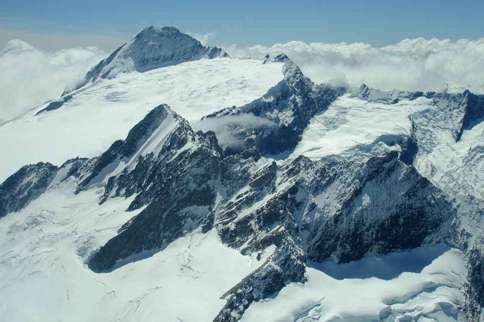
A 3,033 m horn for mountaineers, not day hikers.

Photo: Wikimedia Commons

Overview

About Mount Aspiring / Tititea

Why stop

  • A sharp, glaciated peak rising dramatically above the Matukituki Valley.

Heads up

  • Reaching the summit takes a technical, multi-day mountaineering climb.

Map

Where it is

Loading the Mount Aspiring map
Full map
SightMount Aspiring / Tititea-44.38416, 168.72796
Keep this map with you offline in the Parkwolf app

Plan your stop

Before you go

1 active Mount Aspiring alert

  • CautionRob Roy Track: stop at lower lookout during avalanche seasonFrom May through November, end your Rob Roy Track hike at the lower lookout; DOC strongly recommends against continuing to the upper lookout because the track crosses active avalanche paths.Official details

Mount Aspiring alerts
A park ranger sits on a dash-mounted phone, talking, as Parkwolf’s Tour Guide plays “Army Cutworm Moths: A Grizzly Bear Buffet” on Grand Loop Road below Dunraven Pass in Yellowstone
Parkwolf Tour GuideThe highest, rockiest slopes around here are a summer buffet for grizzly bears.

Mount Aspiring Tour Guide

Your drive to Mount Aspiring / Tititea, narrated.

Parkwolf is a GPS audio tour guide for Mount Aspiring National Park. As you drive, it chimes in with what’s ahead: hidden gems, upcoming stops, history, geology, and wildlife, right through your car’s speakers.

See the Mount Aspiring audio tour
  • 80 audio storiesacross Mount Aspiring’s roads, triggered by GPS as you drive
  • Wildlife heatmapsfor Kea, Rockwren, Yellowhead, and 8 more
  • Works offlinemaps, 50 trails, 52 places, and audio download before you lose signal
  • CarPlay readysimple controls built for the drive
★★★★★
“Fantastic app with many points of information… It’s great to just turn on while you’re driving and it gives you an audio tour of the national Park. We love it!!!!”
JMJamesApp Store review
Download Parkwolf on the App StoreGet Parkwolf on Google Play

4.7 from 8,600+ ratings

Guide

More about Mount Aspiring / Tititea

What it isMount Aspiring / Tititea is a 3,033-metre glaciated peak in the Southern Alps, rising roughly…

Mount Aspiring / Tititea is a 3,033-metre glaciated peak in the Southern Alps, rising roughly 2,500 metres above the Matukituki Valley. Its sharp horn is the namesake of the park and the only peak above 3,000 metres outside Aoraki/Mount Cook National Park. The point is the summit itself, not a road end or walk-up lookout.

Reaching the top is a mountaineering tripA summit attempt is a technical climb involving glacier travel, steep snow and exposed rock.

A summit attempt is a technical climb involving glacier travel, steep snow and exposed rock. Guided itineraries commonly take about five days: one route flies from the road end, crosses Bonar Glacier to Colin Todd Hut, then allows an acclimatisation day before the summit push. A longer walk-in is another multi-day option. This is not a day hike. Local guides describe The Ramp as the usual early-summer route (November–December) and the Full North West Ridge from January to April; snow and conditions affect route choice. Avalanche danger occurs in parts of the park from June to November, so check current local conditions before committing.

The name TititeaThe Māori name Tititea means “steep peak of glistening white,” a fitting description of its…

The Māori name Tititea means “steep peak of glistening white,” a fitting description of its snowy summit. Māori travelled inland from Foveaux Strait and Coastal Otago to gather forest foods and pounamu; the nearby lakes also had historic settlements. Government surveyor John Turnbull Thompson was the first European recorded to see the mountain, in 1857.

Ice shaped the surrounding AlpsThe Southern Alps’ rocks began forming more than 220 million years ago as sediment and rock…

The Southern Alps’ rocks began forming more than 220 million years ago as sediment and rock above volcanic seafloor. Heat and pressure consolidated them before uplift raised the range. Ice Age glaciers later carved the valleys around the peak, leaving the steep alpine setting that makes Tititea stand apart.

Life in the alpine countryThe park’s alpine areas are home to kea and the threatened rock wren, and chamois range around…

The park’s alpine areas are home to kea and the threatened rock wren, and chamois range around the mountaintops. These are part of the wider high-country wildlife, not guaranteed summit sightings.

Look for the horn from the westThe peak’s sharp profile is especially striking from the west.

The peak’s sharp profile is especially striking from the west. If you have a clear view, include some of the Matukituki Valley below it; that gives the 2,500-metre rise a sense of scale. This summit pin is not itself a public roadside viewpoint.

Wildlife

Wildlife in Mount Aspiring

All Mount Aspiring wildlife maps

Sighting maps show where each species has been reported across Mount Aspiring. Wildlife moves, so no sighting is guaranteed.

Parkwolf’s Mount Aspiring ranking

Top sights in Mount Aspiring

All 52 places
  1. 2Blue PoolsSight
  2. 3Rob Roy GlacierSight
  3. 4Thunder Creek FallsSight
  4. 5Fantail FallsSight
  5. 6Routeburn FallsSight
  6. 7Crucible LakeSight

Take Parkwolf to Mount Aspiring.

The audio tour guide for the drive, plus offline maps, trails, and wildlife heatmaps for when the signal drops.

4.7 from 8,600+ ratings

Download Parkwolf on the App StoreGet Parkwolf on Google Play