Black Rocks in Peak District National Park

Sight · Peak District National Park

Black Rocks

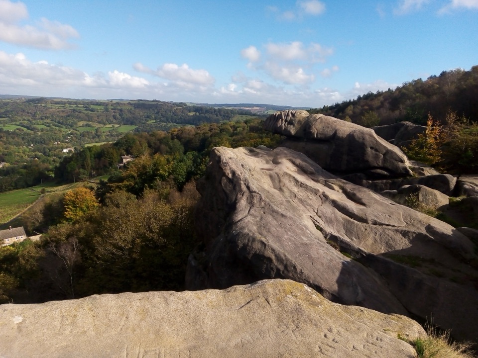
Weathered gritstone crag above Cromford with big views and woodland walks

Photo: Wikimedia Commons
Type
Sight
Audio stories
2 nearby
  • Parking
  • Restrooms
  • Picnic tables
  • Scenic viewpoint

Hear the audio tour

Why Via Gellia Sounds Roman

Overview

About Black Rocks

Why stop

  • Panoramic views from the gritstone outcrop
  • Climbing and woodland walks in one stop

Heads up

  • Short but steep climb to the rocks
  • Busy parking and popular paths at peak times
A short, steep climb from the car park lands you on broad weathered slabs of Ashover grit, where a distinctive balanced boulder formation sits above the wooded valley. It is one of those rare places where panoramic views, rock climbing and quiet woodland circuits all sit within a few minutes of the same parking area, which makes it an easy and rewarding half-day stop rather than a long expedition.
Parkwolf’s verdictWhy stop here

Map

Where it is

Loading the Peak District map
Full map
SightBlack Rocks53.09848, -1.56246
Keep this map with you offline in the Parkwolf app

Plan your stop

Before you go

Best time to go

Early mornings and late afternoons give the kindest light across the valley and the calmest paths. Autumn brings colour through the mixed woodland, while winter strips the trees back for clearer long views. The main trade-offs are simple: the climb to the rocks is steep for its length, and parking and the main paths get busy at peak times, when the popular climbing lines and viewpoints see plenty of company. Visit outside the middle of a fine weekend day and it can feel quiet and unspoiled.


5 active Peak District alerts

  • ClosureA54 Cat and Fiddle road closureThe A54 Macclesfield Main Road (Cat and Fiddle) is fully closed to all traffic from 27 July through 30 October 2026 during phase 1 improvement works.Official details
  • ClosureHooks Carr (Stanage Popular) car park closureHooks Carr (Stanage Popular) car park will be partially or fully closed from 6 October for four weeks.Official details
See all 5 alerts
A park ranger sits on a dash-mounted phone, talking, as Parkwolf’s Tour Guide plays “Army Cutworm Moths: A Grizzly Bear Buffet” on Grand Loop Road below Dunraven Pass in Yellowstone
Parkwolf Tour GuideThe highest, rockiest slopes around here are a summer buffet for grizzly bears.

Peak District Tour Guide

Your drive to Black Rocks, narrated.

Parkwolf is a GPS audio tour guide for Peak District National Park. As you drive, it chimes in with what’s ahead: hidden gems, upcoming stops, history, geology, and wildlife, right through your car’s speakers.

Recorded for this area

Why Via Gellia Sounds Roman
0:00 / 0:27
“Via Gellia sounds like the name of a Roman road. Its story is much later.”

Plays on the road 2.3 km from Black Rocks in the Parkwolf Peak District Tour Guide.

More stories near here in the app

  • A Cottage Made by Springs
  • The Road Stone from Ible
  • Winster's Hidden Drainage Tunnel
  • The Rock Miners Called Toadstone
  • 298 audio storiesacross Peak District’s roads, triggered by GPS as you drive
  • Wildlife heatmapsfor Red Deer, Red Fox, Eurasian Otter, and 13 more
  • Works offlinemaps, 88 trails, 76 places, and audio download before you lose signal
  • CarPlay readysimple controls built for the drive
★★★★★
“Fantastic app with many points of information… It’s great to just turn on while you’re driving and it gives you an audio tour of the national Park. We love it!!!!”
JMJamesApp Store review
Download Parkwolf on the App StoreGet Parkwolf on Google Play

4.7 from 8,600+ ratings

Guide

More about Black Rocks

The climb to the topThe path up from the car park is short but genuinely steep, and it is the one part of the visit…

The path up from the car park is short but genuinely steep, and it is the one part of the visit that asks for a bit of effort and reasonable footwear. The reward is superb open views over the surrounding countryside. Gentler walking routes lead out from the car park too, so you can enjoy the woods without committing to the ascent. Do not assume the crag top itself is an easy or accessible objective.

Views and the High Peak TrailFrom the rocks the outlook is wide and layered.

From the rocks the outlook is wide and layered. For more, follow the High Peak Trail on foot or by bike: a short stretch to Sheep Pasture Top opens views of Matlock Gorge, Cromford and the Derwent Valley Mills World Heritage Site. Head west along the trail instead and you can reach the National Stone Centre and Middleton Top Countryside Centre and Cycle Hire.

ClimbingThe dark gritstone face is a long-standing climbing venue with a range of grades, from lower…

The dark gritstone face is a long-standing climbing venue with a range of grades, from lower and middle grades through to very hard routes. Expect other climbers on the popular lines at busy times, and treat the rock and the ground below with the usual care.

Woods, geology and mining historyWaymarked walks thread through the Cromford Moor woodlands, mixing deciduous and conifer…

Waymarked walks thread through the Cromford Moor woodlands, mixing deciduous and conifer woodland with heather moorland, all managed in cooperation with the Forestry Commission. The site sits close to the boundary between limestone and gritstone, which helps explain the variety of habitats. This ground was mined for lead, and the spoil on the scree slope now supports lead-tolerant plants known as leadworts. The scree is also a good place to look closely at rocks and minerals, so bring curiosity rather than a hammer.

Practical tipsParking is on site, along with an accessible toilet, a picnic area and on-site information…
  • Parking is on site, along with an accessible toilet, a picnic area and on-site information boards.
  • Marked footpaths, a cycle path and a bridleway spread out from the car park, so walkers, cyclists and riders all have options.
  • Refreshments have been available at weekends and in the high season, but this pattern changes, so plan as if you may need to bring your own food and drink.
  • Wear shoes with grip; the gritstone can be slick and the ascent is short-lived but sharp.

Wildlife

Wildlife in Peak District

All Peak District wildlife maps

Sighting maps show where each species has been reported across Peak District. Wildlife moves, so no sighting is guaranteed.

Parkwolf’s Peak District ranking

Top sights in Peak District

All 76 places
  1. 1Chatsworth HouseSight
  2. 2Mam TorSight
  3. 3Dovedale Stepping StonesSight
  4. 4Ladybower ReservoirSight
  5. 5Stanage EdgeSight
  6. 6Kinder ScoutSight

Take Parkwolf to Peak District.

The audio tour guide for the drive, plus offline maps, trails, and wildlife heatmaps for when the signal drops.

4.7 from 8,600+ ratings

Download Parkwolf on the App StoreGet Parkwolf on Google Play