Devil's Cornfield in Death Valley National Park

Scenic pullout · Death Valley National Park

Devil's Cornfield

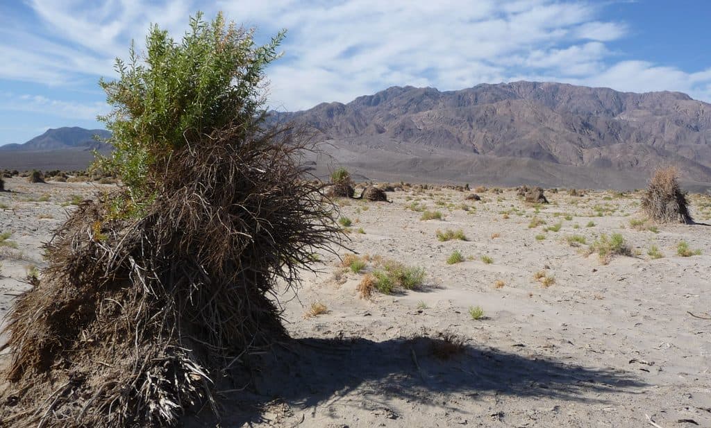
Quirky arrowweed mounds that look like shocks of corn

Photo: Wikimedia Commons
Type
Scenic pullout
Nearest trail
3.6 mi
Audio stories
1 nearby
  • Pullout
  • Parking
  • Scenic viewpoint

Hear the audio tour

Devil's Cornfield: A Landscape Shaped by Wind

Overview

About Devil's Cornfield

Devil's Cornfield is a quirky roadside stop along CA-190 where clumps of arrowweed punctuate a broad, sandy plain. From a distance, these bundles look like shocks of harvested corn—hence the name. It sits a few miles east of Stovepipe Wells and near Mesquite Flat Sand Dunes, making it an effortless add-on between bigger sights.

Why stop

  • Unique arrowweed formations that resemble shocks of corn
  • Easy roadside stop with a small pullout and quick photo op

Heads up

  • No shade or amenities
  • Can feel underwhelming if you expect more than a brief stop
This spot is more about desert ecology and geology than drama. The arrowweed’s odd, bundled growth and the wind-carved landscape tell a story of survival and erosion in one of the harshest environments around. Knowing what you’re looking at makes the stop far more rewarding.
Parkwolf’s verdictWhy It’s Interesting

Map

Where it is

Loading the Death Valley map
Full map
Scenic pulloutDevil's Cornfield36.62272, -117.05311
Keep this map with you offline in the Parkwolf app

Local know-how

Tips for visiting Devil's Cornfield

  1. Use the pullout and never stop in the travel lane.

  2. Bring water and sun protection; there’s no shade and it gets hot.

  3. Early or late light makes the arrowweed shapes pop in photos.

  4. Step carefully and avoid trampling vegetation when you wander out.

  5. Combine with a visit to nearby Mesquite Flat Sand Dunes.

Plan your stop

Before you go

Best time to visit

Early morning or late afternoon brings softer light, cooler temps, and better contrast on the arrowweed mounds. It’s rarely crowded. If you’re night driving, the open horizon can make for pleasant stargazing on clear nights, but keep stops brief and stay well off the road.

3 active Death Valley alerts

  • ClosurePark roads closed or hazardousPlan around multiple closed roads and use extra caution on damaged routes. - Paved roads: North Highway and Beatty Cut-off are closed due to flooding and debris from the October 22 storm.Official details
  • ClosureSaline Valley Lower Springs closed after wildfireLower Springs at Saline Valley Warm Springs remains closed after the September 15 wildfire; stay out because the fire left safety hazards, including potential hazardous chemicals.Official details
See all 3 alerts
A park ranger sits on a dash-mounted phone, talking, as Parkwolf’s Tour Guide plays “Army Cutworm Moths: A Grizzly Bear Buffet” on Grand Loop Road below Dunraven Pass in Yellowstone
Parkwolf Tour GuideThe highest, rockiest slopes around here are a summer buffet for grizzly bears.

Death Valley Tour Guide

Your drive to Devil's Cornfield, narrated.

Parkwolf is a GPS audio tour guide for Death Valley National Park. As you drive, it chimes in with what’s ahead: hidden gems, upcoming stops, history, geology, and wildlife, right through your car’s speakers.

See the Death Valley audio tour

Recorded for this place

Devil's Cornfield: A Landscape Shaped by Wind
Listen
“That strange-looking landscape you're seeing is known as the Devil's Cornfield. Those aren't corn stalks, but clumps of a tough desert plant called arrowweed.”

Plays as you drive up to Devil's Cornfield in the Parkwolf Death Valley Tour Guide.

More stories near here in the app

  • Reading the Night's Story on the Dunes
  • Stovepipe Wells Village: Desert Outpost and Dune Gateway
  • Stovepipe Wells Campground: The Convenient Basecamp
  • Stovepipe Wells Airport: A Runway for Stargazing
  • 130 audio storiesacross Death Valley’s roads, triggered by GPS as you drive
  • Wildlife heatmapsfor Bighorn Sheep, Desert Tortoise, Coyote, and 13 more
  • Works offlinemaps, 36 trails, 114 places, and audio download before you lose signal
  • CarPlay readysimple controls built for the drive
★★★★★
“Fantastic app with many points of information… It’s great to just turn on while you’re driving and it gives you an audio tour of the national Park. We love it!!!!”
JMJamesApp Store review
Download Parkwolf on the App StoreGet Parkwolf on Google Play

4.7 from 8,600+ ratings

Guide

More about Devil's Cornfield

What You'll SeeExpect a flat, open expanse dotted with bushy, stick-like mounds of arrowweed rising from the…

Expect a flat, open expanse dotted with bushy, stick-like mounds of arrowweed rising from the sand. Many sit on little pedestals with exposed roots; wind has scoured away the looser sand over time, leaving the plants perched above the current surface. The area lacks protective desert pavement, so it’s a classic deflation basin sculpted by relentless winds.

WildlifeWildlife isn’t the headline here, but you might notice insects or small desert reptiles using…

Wildlife isn’t the headline here, but you might notice insects or small desert reptiles using the sparse cover. Don’t expect marquee wildlife encounters.

Make the Most of ItTreat it as a photo break and stretch-your-legs moment rather than a destination.

Treat it as a photo break and stretch-your-legs moment rather than a destination. Wander a short distance from the pullout for cleaner compositions, but avoid trampling vegetation.

Know Before You GoThere are no restrooms, water, or services here—just a small roadside pullout and the view.

There are no restrooms, water, or services here—just a small roadside pullout and the view. Summer heat can be intense; bring water and sun protection, even for a short stop.

Wildlife

Wildlife in Death Valley

All Death Valley wildlife maps

Sighting maps show where each species has been reported across Death Valley. Wildlife moves, so no sighting is guaranteed.

Parkwolf’s Death Valley ranking

Top sights in Death Valley

All 114 places
  1. 1Badwater BasinSight
  2. 2Dante's ViewSight
  3. 3Mesquite Flat Sand DunesSight
  4. 4Zabriskie PointSight
  5. 5Golden CanyonSight
  6. 6Artists PaletteSight

Take Parkwolf to Death Valley.

The audio tour guide for the drive, plus offline maps, trails, and wildlife heatmaps for when the signal drops.

4.7 from 8,600+ ratings

Download Parkwolf on the App StoreGet Parkwolf on Google Play