Pros & cons
PROS
- Quick road access to subalpine views and tarns
- Basic facilities: parking, toilet, and info panels
- Quieter than the park’s headline spots
CONS
- Unsealed, narrow, steep road with seasonal closures
- No fuel, services, or cell coverage
- Not suitable for campervans, caravans, or trailers
Overview
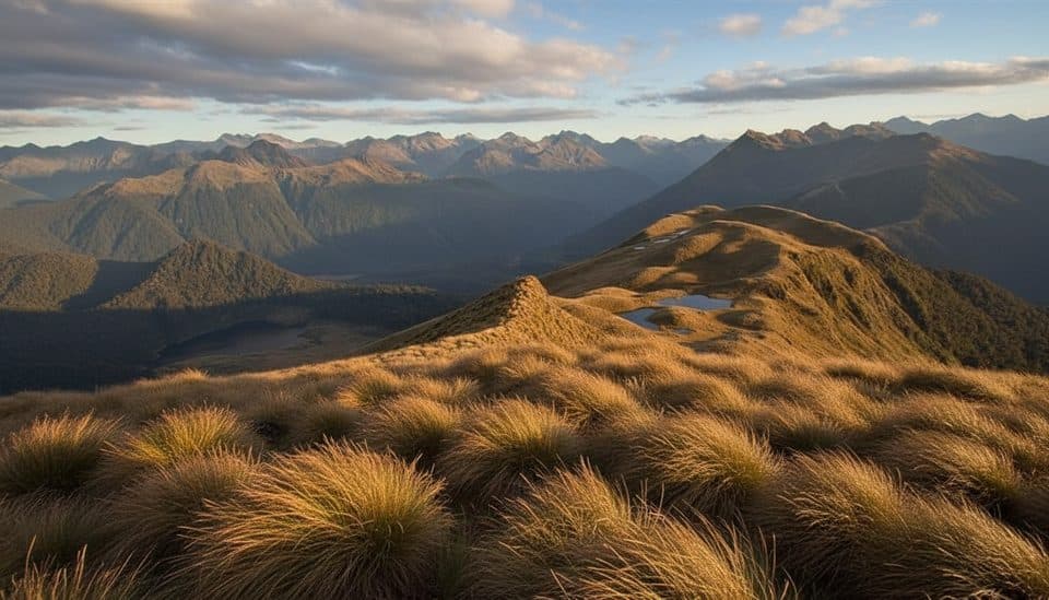
Borland Saddle is the high point of Borland Road (about 990 m), a remote, gravel access reaching well above the bush line. It’s one of the rare places you can step out of the car and almost immediately be in open alpine country—think big Fiordland views without a massive approach.
What you’ll see and do
- Views: Broad alpine vistas over the Hunter Mountains and Grebe Valley, with interpretive panels to put the landscape in context.
- Short, steep alpine walking: The Mt Burns tarns/tops are the classic hit here—expect a sharp climb through silver beech to alpine tarns and wide‑open tops with superb outlooks.
- Longer tramping options: Tracks in the Borland corridor (e.g., Green Lake and North Borland) are accessed from this road network; the saddle is a common jumping‑off point.
- Bonus pursuits: Mountain biking is permitted on Borland Road, and climbers use nearby faces; it’s a genuine multi‑activity backcountry gateway.
History and geology
The road was pushed in for the Manapouri hydro scheme, which is why you can drive so high in such a wild corner. From the saddle you’re looking into the aftermath of a colossal ancient landslide—tens of cubic kilometres of the Hunter Mountains slumped toward the Lake Monowai basin after glacial retreat and seismic shaking, leaving scars still visible today.
Nature and wildlife
Around the saddle you’ll pass silver beech draped in lichens, then alpine herbfields and flowers above the trees. More than 45 bird species have been recorded in the wider area, so keep your ears open; this valley was historically important to Māori for birds and eels.
Getting there and what to expect
Borland Road is unsealed, narrow and steep in places, with risks of slips, ice/snow, and windfall. It’s typically a summer‑season road and can close without much notice—always check current alerts before you go. There’s a car park, toilet, and natural history signage at the saddle, but no fuel, food, or cell service. Standard vehicles may manage in good conditions, but the road is not suitable for campervans, caravans, or trailers; many prefer 4WD for peace of mind.
Is it worth it?
If you’re chasing alpine scenery without a huge time investment, this is a gem—underrated, quiet, and wildly scenic. If you want paved convenience and facilities, look elsewhere.
Best time to visit
Aim for summer or any spell when Borland Road is open and stable. Go on clear, calm days for the best distant views; mornings often deliver crisper air and nicer light. Midweek tends to feel even more solitary, though this area is generally low‑traffic.

Where it is
-45.7458, 167.3803Tips for Borland Saddle
- 01Check DOC alerts for Borland Road before you go; closures are common.
- 02Carry all fuel, food, and water—there are no services on the road.
- 03Expect no cell reception; have a backup plan for emergencies.
- 04Pack warm, waterproof layers—the weather flips fast at 990 m.
- 05If conditions are marginal, consider a 4WD; avoid large vehicles and trailers.
Amenities
Near Borland Saddle
All places →All trails →
0 mi awayMount Burns Tarns TrackShort, punchy climb to mirror-like alpine tarns above Borland SaddleModerate · 0.9 mi · 1 hr
0 mi awayMt Burns RouteAlpine tarns and big Fiordland views with a quiet, wild feelChallenging · 6.2 mi · 6.5 hr
1.2 mi awayMount BurnsTarn-studded alpine ridge with big Fiordland views and few peopleTrailhead · Parking
7.9 mi awayBorland Nature WalkMossy beech forest loop with a swing bridge and zero crowds.Easy · 1.4 mi · 36 min
8.2 mi awayGreen Lake TrackRemote Fiordland tramp to a serene alpine lake and hutChallenging · 10.6 mi · 9 hr
8.8 mi awayMount TitiroaSnow-white granite summit with wild boulders and vast Fiordland viewsScenic Viewpoint
9.8 mi awayLake MonowaiQuiet lake with forest campsite, trout, and hydro historyTrailhead · Restroom
10.8 mi awayLake RoeRemote alpine lake ringed by tarns on the Dusky TrackRestroom