Pros & cons
PROS
- Tarn-studded alpine tops with standout flora
- Big Fiordland views with far fewer people
CONS
- Borland Road access can close without warning
- Summit requires off-track navigation and scrambling
Overview
Mount Burns rises above Borland Saddle in the park’s quieter south, delivering a classic Fiordland mix: mossy beech forest, tussock tops, rocky ridges, and a string of alpine tarns. It’s a rewarding alternative to the busy northern icons, with real solitude and big mountain drama.
What You’ll See
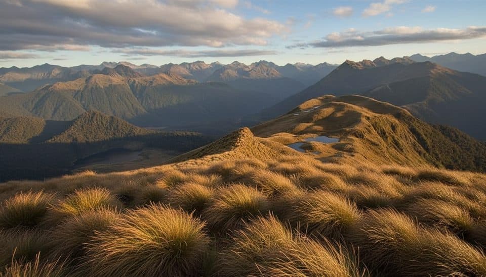
Expect lush lower forest giving way to open alpine herbfields and tussock, then a tarn-studded ridge with panoramic views. On clear days you can spot the Hope Arm of Lake Manapouri, the Shag Valley, and a sweep of Fiordland peaks and valleys. The botany is a highlight here—think cushion plants and speargrass (Aciphylla), with DOC and safety groups noting endemic species and even nationally threatened plants near the tops. Tread lightly.
Route and Difficulty
DOC classifies the Mt Burns Tarns Track as an advanced tramping track. It’s a short but steep outing to the tarns—about 1 km return and roughly 45 minutes return for many—yet it feels properly alpine as soon as you break the treeline. Reaching the true summit is a different game: beyond the marked track you’ll need solid route-finding and comfort on a rocky ridge with some scrambling. The tops are exposed; in poor weather the track can be muddy and conditions change fast.
Why It’s Special
Compared with the park’s headline trails, Mount Burns stays blissfully uncrowded. The tight cluster of tarns close to the ridge makes the landscape feel intimate and photogenic, and the diverse alpine plant life is a genuine point of difference—even seasoned hikers linger to look more closely here.
Access and Logistics
Access is via Borland Road to Borland Saddle. That road is unsealed and can close due to weather or conditions, so check DOC’s current status before you go. There’s parking at the saddle and a signed start for the track; there are no services on the route, so bring everything you need. If you aren’t equipped for off-track travel, the tarns are still a superb turnaround point.
Best Time to Visit
Pick a clear-weather window for the views and safer travel on the exposed tops. Weekdays are typically quieter, though this area rarely feels busy. Early or late in the day gives softer light on the tarns and ridgelines. Always reassess if conditions deteriorate.

Low-Impact Tips
This is a fragile alpine environment with endemic and threatened species—stick to the formed track where possible and step carefully around vegetation, especially near the tarns.
Where it is
-45.7467, 167.4042Tips for Mount Burns
- 01Check Borland Road status with DOC before you go.
- 02Stick to the formed track to protect fragile alpine plants.
- 03If aiming for the summit, bring navigation tools and be comfortable off-track.
- 04Carry full foul-weather gear—the tops are exposed and conditions change fast.
- 05Sandflies can be persistent; pack repellent.
Amenities
Near Mount Burns
All places →All trails →
1.2 mi awayMount Burns Tarns TrackShort, punchy climb to mirror-like alpine tarns above Borland SaddleModerate · 0.9 mi · 1 hr
1.2 mi awayMt Burns RouteAlpine tarns and big Fiordland views with a quiet, wild feelChallenging · 6.2 mi · 6.5 hr
1.2 mi awayBorland SaddleRoad-accessed alpine saddle to big views and Mt Burns tarnsTrailhead · Pullout
6.7 mi awayBorland Nature WalkMossy beech forest loop with a swing bridge and zero crowds.Easy · 1.4 mi · 36 min
7.2 mi awayGreen Lake TrackRemote Fiordland tramp to a serene alpine lake and hutChallenging · 10.6 mi · 9 hr
8 mi awayMount TitiroaSnow-white granite summit with wild boulders and vast Fiordland viewsScenic Viewpoint
9.6 mi awayLake MonowaiQuiet lake with forest campsite, trout, and hydro historyTrailhead · Restroom
11.9 mi awayLake RoeRemote alpine lake ringed by tarns on the Dusky TrackRestroom