Ingleton Springs Picnic Area in Grampians National Park

Picnic area · Grampians National Park

Ingleton Springs Picnic Area

A quiet eucalyptus picnic stop in a ferny spring clearing

Type
Picnic area
Nearest trail
3 km
Audio stories
6 nearby
  • Parking
  • Picnic tables

Hear the audio tour

The Mice That Survived the Fire

Overview

About Ingleton Springs Picnic Area

Why stop

  • Quiet, ferny eucalyptus setting with a genuine picnic table

Heads up

  • A low-key stop with little to do beyond a short break
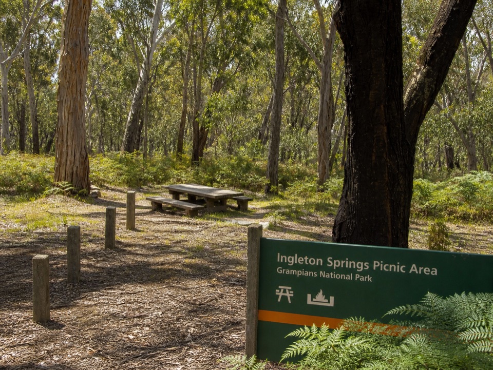
Ingleton Springs is a quiet, low-key picnic stop in eucalyptus woodland on the western side of Gariwerd. The attraction is the setting: ferns, peeling trunks, leaf litter, and a small clearing that feels tucked away from the park's marquee lookouts and waterfalls. The springs are subtle rather than theatrical, so think damp woodland and a gentle pause, not a big cascade.
Parkwolf’s verdictWhy stop

Map

Where it is

Loading the Grampians map
Full map
Picnic areaIngleton Springs Picnic Area-37.30056, 142.36977
Keep this map with you offline in the Parkwolf app

Plan your stop

Before you go

Best time to go

Navigate to the exact picnic-area pin on Syphon Road rather than relying on the similar-sounding Ingleton Track. The approach is a bush-road stop, so allow extra time in wet weather and check the park's road conditions before setting out. Bring your own food and drinking water; no dependable potable-water supply is verified here.

Spring and autumn give the ferny understory its best color, while early morning or late afternoon brings softer light through the trees. The area is most likely to feel peaceful on weekdays and outside school-holiday periods. Look quietly for small birds and other bush wildlife, but keep expectations modest and leave the animals undisturbed.


5 active Grampians alerts

  • ClosureBushfire-damaged walks and picnic area remain closedThe Fortress, Red Gum, Billimina, Chimney Pots and Brownings Loop walks, plus Mafeking Picnic Area, remain closed because of track or site damage from the 2024/25 summer bushfires.Official details
  • ClosureMackenzie Falls precinct closed during constructionThe Mackenzie Falls (Migunang wirab) Precinct has no vehicle or visitor access during major construction works expected to finish by the end of 2026.Official details
See all 5 alerts
A park ranger sits on a dash-mounted phone, talking, as Parkwolf’s Tour Guide plays “Army Cutworm Moths: A Grizzly Bear Buffet” on Grand Loop Road below Dunraven Pass in Yellowstone
Parkwolf Tour GuideThe highest, rockiest slopes around here are a summer buffet for grizzly bears.

Grampians Tour Guide

Your drive to Ingleton Springs Picnic Area, narrated.

Parkwolf is a GPS audio tour guide for Grampians National Park. As you drive, it chimes in with what’s ahead: hidden gems, upcoming stops, history, geology, and wildlife, right through your car’s speakers.

Recorded for this area

The Mice That Survived the Fire
0:00 / 0:30
“After fire swept through the Victoria Range in two thousand thirteen, researchers returned to a gully where they'd been studying smoky mice. These small native rodents spend their days in shared underground burrows.”

Plays on the road 0.3 km from Ingleton Springs Picnic Area in the Parkwolf Grampians Tour Guide.

More stories near here in the app

  • A Replacement Tail
  • The Blue-Grey Sheoak
  • The Trail Inside a Leaf
  • Leaves from the Trunk
  • 233 audio storiesacross Grampians’s roads, triggered by GPS as you drive
  • Wildlife heatmapsfor Short-beaked Echidna, Powerful Owl, Wedge-tailed Eagle, and 13 more
  • Works offlinemaps, 81 trails, 62 places, and audio download before you lose signal
  • CarPlay readysimple controls built for the drive
★★★★★
“Fantastic app with many points of information… It’s great to just turn on while you’re driving and it gives you an audio tour of the national Park. We love it!!!!”
JMJamesApp Store review
Download Parkwolf on the App StoreGet Parkwolf on Google Play

4.7 from 8,600+ ratings

Guide

More about Ingleton Springs Picnic Area

What to expectThis is a good place to unpack lunch, stretch your legs, and slow down between longer drives or…

This is a good place to unpack lunch, stretch your legs, and slow down between longer drives or walks. A rustic timber picnic table and bench sit among the trees, with low timber bollards marking the clearing. The surrounding bush is the main event, and the site is better suited to a calm 20- to 40-minute break than a destination visit on its own.

Keep it simpleThis is a day-use site: camping is not permitted, and dogs are not allowed.

This is a day-use site: camping is not permitted, and dogs are not allowed. Pack out everything, stay alert beneath the trees, and be prepared for a basic bush setting rather than a staffed facility or a fully serviced picnic ground.

Wildlife

Wildlife in Grampians

All Grampians wildlife maps

Sighting maps show where each species has been reported across Grampians. Wildlife moves, so no sighting is guaranteed.

Parkwolf’s Grampians ranking

Top sights in Grampians

All 62 places
  1. 1MacKenzie Falls (Migunang wirab)Sight
  2. 2Pinnacle LookoutSight
  3. 3Boroka LookoutSight
  4. 4Reeds LookoutSight
  5. 5The BalconiesSight
  6. 6Mount William (Duwul)Sight

Take Parkwolf to Grampians.

The audio tour guide for the drive, plus offline maps, trails, and wildlife heatmaps for when the signal drops.

4.7 from 8,600+ ratings

Download Parkwolf on the App StoreGet Parkwolf on Google Play