Walhalla Overlook in Grand Canyon National Park

Sight · Grand Canyon National Park

Walhalla Overlook

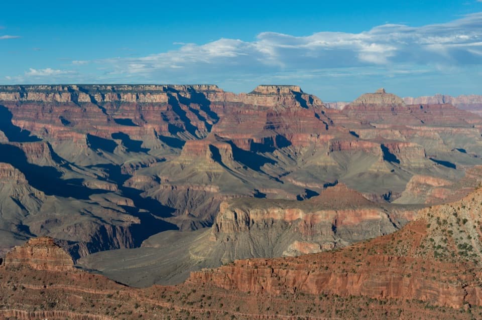
A broad Unkar Delta view, with a pueblo across the road.

Photo: Wikimedia Commons
Type
Sight
Nearest trail
0.1 mi
Audio stories
4 nearby
  • Parking
  • Pullout
  • Scenic viewpoint
  • Exhibit
  • #29 of 58 sights

Hear the audio tour

Walhalla Overlook and Pueblo

Overview

About Walhalla Overlook

Why stop

  • The overlook and nearby pueblo make an easy two-part stop.

Map

Where it is

Loading the Grand Canyon map
Full map
SightWalhalla Overlook36.13159, -111.94181
Keep this map with you offline in the Parkwolf app

Plan your stop

Before you go

4 active Grand Canyon alerts

  • ClosureInner Canyon and North Rim trail closuresMentions North Rim, referenced in this guideDo not enter the closed trails, bridges, campgrounds, and inner-canyon areas.Official details
  • ClosureNorth Rim scenic roads closed for repairsMentions North Rim, referenced in this guideCape Royal Road and Point Imperial Road are closed from sunset October 15 through sunrise November 3, 2026. - The roads are closed to accommodate critical road repair and rehabilitation work.Official details

See all 4 alerts
A park ranger sits on a dash-mounted phone, talking, as Parkwolf’s Tour Guide plays “Army Cutworm Moths: A Grizzly Bear Buffet” on Grand Loop Road below Dunraven Pass in Yellowstone
Parkwolf Tour GuideThe highest, rockiest slopes around here are a summer buffet for grizzly bears.

Grand Canyon Tour Guide

Your drive to Walhalla Overlook, narrated.

Parkwolf is a GPS audio tour guide for Grand Canyon National Park. As you drive, it chimes in with what’s ahead: hidden gems, upcoming stops, history, geology, and wildlife, right through your car’s speakers.

See the Grand Canyon audio tour

Recorded for this place

Walhalla Overlook and Pueblo
0:00 / 0:35
“Walhalla Overlook is coming up, with a canyon view and a pueblo just across the road.”

Plays as you drive up to Walhalla Overlook in the Parkwolf Grand Canyon Tour Guide.

More stories near here in the app

  • Cliff Springs’ Ravine Walk
  • Cape Royal and Angels Window
  • Cape Final’s Forest Walk
  • Why the Map Has Temples
  • 79 audio storiesacross Grand Canyon’s roads, triggered by GPS as you drive
  • Wildlife heatmapsfor California Condor, Bighorn Sheep, American Bison, and 13 more
  • Works offlinemaps, 73 trails, 96 places, and audio download before you lose signal
  • CarPlay readysimple controls built for the drive
★★★★★
“Fantastic app with many points of information… It’s great to just turn on while you’re driving and it gives you an audio tour of the national Park. We love it!!!!”
JMJamesApp Store review
Download Parkwolf on the App StoreGet Parkwolf on Google Play

4.7 from 8,600+ ratings

Guide

More about Walhalla Overlook

A canyon view with a second stop across the roadWalhalla Overlook is a roadside viewpoint on the North Rim’s Cape Royal Road, with a broad view…

Walhalla Overlook is a roadside viewpoint on the North Rim’s Cape Royal Road, with a broad view into the eastern Grand Canyon and down Unkar Creek toward Unkar Delta. It’s an easy stop on the drive; cross the road for the short walk to Walhalla Glades Pueblo, and the view comes with a human story.

Look toward Unkar DeltaThe broad, flat delta below formed from sediment carried out of nearby side canyons.

The broad, flat delta below formed from sediment carried out of nearby side canyons. Indigenous communities farmed and lived here. From the rim, follow Unkar Creek toward the Colorado River and notice how the land opens out at the river’s edge.

Walk to Walhalla Glades PuebloAcross Cape Royal Road, a short path reaches low foundation outlines in a forest clearing.

Across Cape Royal Road, a short path reaches low foundation outlines in a forest clearing. This small masonry pueblo had at least nine rooms and was occupied around 1100–1150 CE. Archaeologist Douglas W. Schwartz spent more than 30 years surveying and excavating sites across Unkar Delta and the nearby plateau; his work uncovered this pueblo. These archaeological places remain sacred to regional tribes, so stay on the designated path and leave artifacts where they are.

Plan the driveFrom Roosevelt Point, continue south about 6.5 miles; the overlook pullout is on the left.

From Roosevelt Point, continue south about 6.5 miles; the overlook pullout is on the left. Cape Royal Road is narrow and winding, with blind corners. Vehicles over 22 feet long and vehicle-trailer combinations over 22 feet aren’t allowed. The road usually opens from about mid-May through November, weather permitting. The overlook is listed as wheelchair accessible, though the accessible surfaces and route aren’t specified. Check current road status before heading out.

Frame the creek and canyonFor the wide view, keep the winding course of Unkar Creek in the frame.

For the wide view, keep the winding course of Unkar Creek in the frame. It leads the eye from the rim toward the delta and shows how the side canyon meets the larger gorge. The viewpoint sits beside its parking pullout, so you don’t need a long walk for the main vista.

Wildlife

Wildlife in Grand Canyon

All Grand Canyon wildlife maps

Sighting maps show where each species has been reported across Grand Canyon. Wildlife moves, so no sighting is guaranteed.

Parkwolf’s Grand Canyon ranking

Top sights in Grand Canyon

All 96 places
  1. 1Mather PointSight
  2. 2Desert View WatchtowerSight
  3. 3Yavapai Geology MuseumSight
  4. 4Hopi PointSight
  5. 5Toroweap OverlookSight
  6. 6Point ImperialSight

Take Parkwolf to Grand Canyon.

The audio tour guide for the drive, plus offline maps, trails, and wildlife heatmaps for when the signal drops.

4.7 from 8,600+ ratings

Download Parkwolf on the App StoreGet Parkwolf on Google Play