Parking
Green Creek Trailhead at the end of Green Creek Road, south of Bridgeport; the final 11 miles of the approach are dirt. Vault toilet, no potable water; lot capacity is not published.
Yosemite National Park, CA
Alpine lakes and a high pass reward skilled backcountry hikers.
Overview
Map & elevation
Plan your hike

Yosemite Tour Guide
Parkwolf is a GPS audio tour guide for Yosemite National Park. As you drive, it chimes in with what’s ahead: hidden gems, upcoming stops, history, geology, and wildlife, right through your car’s speakers.
See the Yosemite audio tour“We just drove through Yosemite and it made our trip listening to this app as we drove through. Like having a tour guide in the car with you.”


Trail guide
Virginia Pass Loop is a 16.71-mile circuit from Green Creek Trailhead through the Hoover Wilderness, Summit Lake and Yosemite Wilderness, over Virginia Pass and back by Glines Canyon. The only complete mileage account gives 4,651 feet of climbing; the mapped line measures 16.07 miles, so expect some variation in this faint, partly unmaintained route. A detailed outing took two nights. This is a demanding backpack for experienced hikers who can navigate where tread fades, not a maintained day hike.
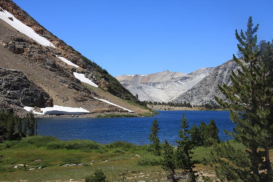
From the 8,000-foot trailhead, Green Creek Trail climbs through forest, crosses Green Creek several times and reaches Green Lake. Continue past East Lake and smaller lakes; the woods open around Hoover Lakes into boulder fields and wildflower meadows below Epidote Peak. The climb to Summit Lake tops out around 10,183 feet. Its west shore marks the crossing from Hoover Wilderness into Yosemite Wilderness, and the lake’s still water gives a good reflection view of the surrounding peaks.
From Summit Lake, the route drops roughly 800 feet into Virginia Canyon, crosses Return Creek repeatedly and climbs toward Return Lake and the cirque below Virginia Peak. The Virginia Pass Trail is faint and rarely traveled; in places the tread comes and goes across rocky ground. An unnamed lake lies beneath Virginia Peak among open creek meadows, where the faint tread comes and goes across rocky ground; there is no dependable signed itinerary.
The climb to the low saddle at Virginia Pass, about 10,550 feet, is steep and partly over loose scree. From the pass, look down Virginia Canyon and across to Shepherd Crest, with the Cathedral Range in the distance. The descent into Glines Canyon is also loose and the trail is faint; it follows the West Fork of Green Creek past cascades, wildflowers and old mining equipment, then rejoins the popular Green Creek Trail near Green Lake. For a shorter outing, walk the marked Green Creek Trail to Green Lake and turn back before the pass loop. A strong photo is the Summit Lake shoreline with water and the surrounding peaks in the frame.
Green Creek Trailhead is a Forest Service access south of Bridgeport, outside Yosemite. The final 11 miles of the approach are dirt road; there is a vault toilet but no potable water, and access is usually late May to early October depending on weather. Day hikes in Hoover Wilderness do not require a permit, but overnight trips require a Hoover Wilderness permit. A separate Yosemite permit is not required when the continuous itinerary starts in Hoover and continues into Yosemite; follow Yosemite’s wilderness rules while there. Approved bear-resistant canisters are required, and pets are prohibited on Yosemite trails and in its wilderness, so pets cannot accompany this loop.
Wildlife
 732 sightingsBlack BearMost seen around 7 PMSighting map
 1,747 sightingsMule DeerMost seen around 6 PMSighting map
 332 sightingsCoyoteMost seen around 7 PMSighting map
 11 sightingsPeregrine FalconMost seen around 8 AMSighting map
 276 sightingsPikaMost seen around 8 AMSighting map
 677 sightingsYellow-bellied MarmotMost seen around 8 AMSighting map
Sighting maps show where each species has been reported across Yosemite. Wildlife moves, so no sighting is guaranteed.
Keep exploring
 ChallengingBenson Lake and Matterhorn Canyon Loop49 mi · 1.7 days · 6.7 mi awayFive days of high passes, lake beaches and long backcountry miles.
 ChallengingCrown Lake, Kerrick Meadow and Peeler Lake Loop24.3 mi · 14 hr · 6.7 mi awayA high Sierra loop links granite lakes, a pass and remote meadow.
 ModerateRodgers Lake Trail4.1 mi · 2.5 hr · 13.9 mi awayA small saddle opens onto granite slabs beside the lake.
 ChallengingMount Dana Trail5.4 mi · 6 hr · 14 mi awayA steep summit push with Mono Lake, Dana Lake, and Sierra views.
 ModerateGaylor Lakes Trail3.6 mi · 3 hr · 14 mi awayA steep pass opens onto the Gaylor Lakes basin.
Parkwolf’s Yosemite ranking

The audio tour guide for the drive, plus offline maps, trails, and wildlife heatmaps for when the signal drops.





