Pros & cons
PROS
- Short loop to two stone-walled overlooks with different views
- Picnic tables and restrooms at the trailhead
CONS
- Access road and trailhead closed for a long-term project in 2025
- Waterflow can be thin in late summer or dry spells
Overview
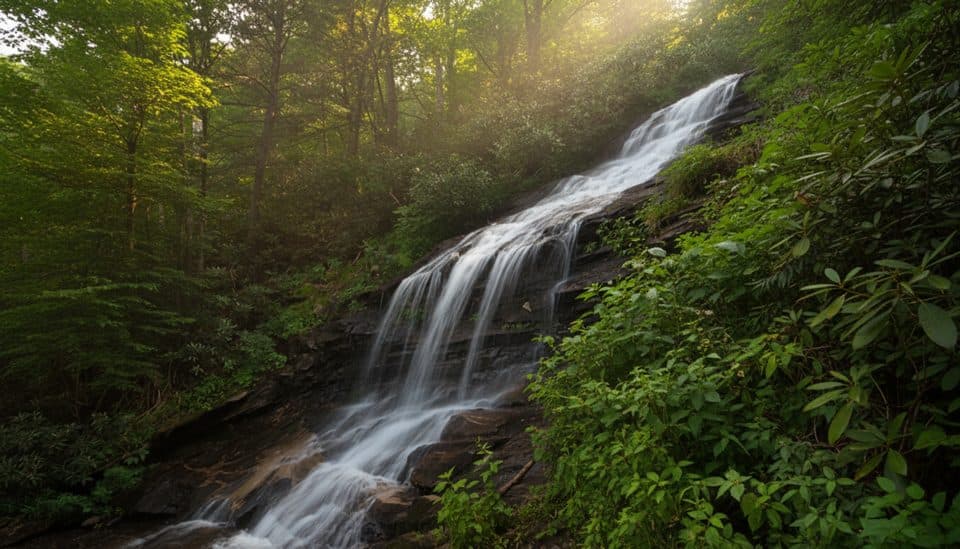
Tucked into E.B. Jeffress Park around milepost 272, The Cascades is a classic Parkway waterfall: a long, high, multi‑drop slide on Falls Creek framed by hardwood forest. It’s reached by a 0.8–1 mile self‑guided loop with interpretive signs—easy to moderate overall—with steps and a noticeable descent to the lower viewpoint.
The Trail and Views
The loop leads to two stone‑walled overlooks. The upper platform looks onto a series of short cascades and the beginning of the long rock slide. Continue down to the lower overlook for the money shot: the main slide plunging steeply down the cliff. Expect about 250 feet of elevation loss to reach the lower view, then retrace uphill to complete the loop. Benches along the path make it an easy breather stop.
What Makes It Different
Unlike many quick roadside falls, this one pairs a short, engaging forest walk with well‑placed viewpoints and a true sense of the Blue Ridge escarpment—the creek tumbling toward the Piedmont far below. The interpretive plaques spotlight local trees and shrubs, turning a simple stroll into a mini field course.
Seasonal Nature and Wildlife
Spring brings wildflower color and fresh foliage; early summer stays lush. After steady rain, the falls are at their best. Late summer or drought can thin the flow. Expect the usual woodland soundtrack—songbirds, squirrels, and the rush of Falls Creek—more than big‑ticket wildlife.

Amenities
At the trailhead you’ll find a paved parking area, restrooms, and plenty of picnic tables—great for a post‑hike lunch. There are no concessions, water filling stations, or camping here, so come prepared.
Safety Basics
Stay on the marked path and behind the stone walls; slick rock near the brink has been a problem. The trail can be slippery after rain—wear shoes with good tread. No swimming or scrambling down to the creek at the falls.
Best Time to Visit
- After rain for the strongest flow and best photos
- Weekday mornings to dodge weekend and leaf‑season crowds
- Spring for wildflowers; late October for color, though water may be lower
Current Status
As of the 2025 season, the Parkway access to E.B. Jeffress Park and The Cascades trailhead is closed for a long‑term construction project. Check the official Parkway road status page before planning a visit.
Where it is
37.3673, -80.5759Tips for The Cascades
- 01For the best view, continue to the lower overlook before turning back.
- 02Visit after a soaking rain; flow drops off in late summer.
- 03Start early on weekends and during fall color to avoid crowding.
- 04Bring your own water and lunch—there are no services here.
- 05Check current Parkway closures before you drive out.
Amenities
Near The Cascades
All places →All trails →
30.6 mi awayRoanoke Mountain OverlookSummit views over Roanoke via a quiet, one-way mountain loopPullout · Parking
30.6 mi awayRoanoke Valley OverlookCity-meets-mountains vista without leaving your carPullout · Parking
35 mi awayPine Spur OverlookQuiet pullout with big Blackwater Valley views and a poignant pastPullout · Parking
35.7 mi awayRoanoke Mountain Picnic AreaShady picnic hub with grills and quick access to Roanoke viewsTrailhead · Restroom
35.7 mi awayChestnut Ridge Loop TrailShady hardwood loop with easy grades and great birding near RoanokeModerate · 5.4 mi · 2.5 hr
35.7 mi awayRoanoke Mountain Woodland TrailMini summit loop with big Roanoke Valley views.Easy · 0.4 mi · 15 min
37.1 mi awaySmart View Loop TrailMellow meadows, woods, and a historic cabin on a quiet loop.Easy · 3 mi · 2 hr
39 mi awayStewart Knob TrailQuick, quiet leg-stretcher with Blue Ridge views near RoanokeEasy · 0.5 mi · 18 min