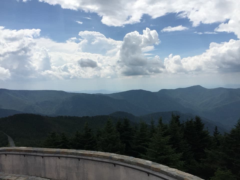
Black Mountain Crest Trail in Blue Ridge Parkway

Blue Ridge Parkway, NC · VA

Black Mountain Crest Trail

Ten peaks, fixed ropes, and a long descent to Bowlens Creek.

Photo: Brian Stansberry / Wikimedia Commons / CC BY 3.0

Length
11.3mi
Time
10hr
Elev. change
3,360ft
Difficulty
Challenging
  • Dogs allowed
  • High point 6,535 ft
  • #42 of 145 in Blue Ridge Parkway

Hear the audio tour

Mount Mitchell: The Road to the Summit

Overview

About Black Mountain Crest Trail

Why go

  • A true crest traverse with named high peaks and open views in both directions.
  • The Celo meadow and Mount Craig deliver very different ridge viewpoints.

Heads up

  • Big Tom’s steep north face has fixed ropes; the tread stays rough beyond it.
  • The 11.3-mile one-way route requires a shuttle and a very long day.
Black Mountain Crest Trail is an 11.3-mile one-way traverse from the picnic area below Mount Mitchell’s summit parking to Bowlens Creek Road. In this direction, the route climbs about 1,650 feet and drops roughly 5,100 feet; allow 9 to 11 hours and arrange a shuttle before you start. It crosses the high Black Mountain ridge, with roots, rocks, repeated climbs and a fixed-rope section. It’s a serious full-day outing for experienced hikers. The popular Mount Craig walk is a separate 2.1-mile round trip, not a shortened version of this traverse.
Parkwolf’s verdictIs this the hike for you?

Map & elevation

The route

Loading the Blue Ridge Parkway map
Full map
Elevation3,176–6,535 ft
TrailheadBlack Mountain Crest Trailhead at the Mount Mitchell picnic area35.76732, -82.26469
Keep this map with you offline in the Parkwolf app

Plan your hike

Before you go

Parking

Start at the Black Mountain Crest Trailhead at Mount Mitchell State Park’s picnic area below summit parking. The Bowlens Creek Road terminus is a small unmarked pull-off with room for only a handful of small vehicles and no facilities; arrange a shuttle. Overnight parking at the summit lot requires free ranger registration. The approach uses the Blue Ridge Parkway, which can close during winter ice.

Safety

Big Tom’s steep north face uses fixed ropes, and the route has rough, rooted footing and repeated climbs. High-ridge weather can change quickly, with wind, cloud, summer thunderstorms and lingering spring ice. Parkway access may close during winter ice.

7 active Blue Ridge Parkway alerts

  • ClosureWeather closures near Craggy Gardens and southern ParkwayWeather closures block Parkway sections near Craggy Gardens and south of Beech Gap, as well as Mount Mitchell State Park and Heintooga Spur Road; do not enter closed roads. - MP 355.3–375.Official details
  • ClosureHurricane Helene closures and hazards in North CarolinaDo not enter closed Parkway sections, trails, facilities, or adjacent NPS lands in North Carolina; recreation is prohibited in the closed NC Highway 80–Mount Mitchell section. - The MP 344.2–355.Official details
See all 7 alerts
A park ranger sits on a dash-mounted phone, talking, as Parkwolf’s Tour Guide plays “Army Cutworm Moths: A Grizzly Bear Buffet” on Grand Loop Road below Dunraven Pass in Yellowstone
Parkwolf Tour GuideThe highest, rockiest slopes around here are a summer buffet for grizzly bears.

Blue Ridge Parkway Tour Guide

Your drive to Black Mountain Crest Trail, narrated.

Parkwolf is a GPS audio tour guide for Blue Ridge Parkway. As you drive, it chimes in with what’s ahead: hidden gems, upcoming stops, history, geology, and wildlife, right through your car’s speakers.

See the Blue Ridge Parkway audio tour

Recorded for this trailhead

Mount Mitchell: The Road to the Summit
0:00 / 0:32
“You're approaching the turnoff onto North Carolina one twenty-eight for Mount Mitchell State Park.”

Plays as you drive up to this trailhead in the Parkwolf Blue Ridge Parkway Tour Guide.

More stories near here in the app

  • The Survey That Cost Mitchell His Life
  • Ridge Junction: A Roadside View or a Summit Walk
  • Mount Mitchell Overlook: A View Toward the Mountain
  • Walker Knob: The Hike to Little Butt
  • 298 audio storiesacross Blue Ridge Parkway’s roads, triggered by GPS as you drive
  • Wildlife heatmapsfor Black Bear, Elk, White-tailed Deer, and 13 more
  • Works offlinemaps, 145 trails, 251 places, and audio download before you lose signal
  • CarPlay readysimple controls built for the drive
★★★★★
“…We knew we wanted to drive the Blue Ridge Parkway. The narration was impeccably timed. The facts and info provided were meaningful. Without it, the trip would not have been near as awesome.”
Ashl GApp Store review
Download Parkwolf on the App StoreGet Parkwolf on Google Play

4.7 from 8,600+ ratings

Trail guide

Hiking Black Mountain Crest Trail

Start north on Deep Gap TrailFollow orange triangles from the picnic area.

Follow orange triangles from the picnic area. A restored log cabin is a landmark at the start, and the early gravel soon turns into roots and rocks. About a mile in, you reach Mount Craig at 6,647 feet, the East’s second-highest peak. Many hikers turn here: the 2.1-mile round trip gives you an early crest view without the rougher route that follows. If you’re doing the full route, don’t mistake the common turnaround for its endpoint.

Big Tom to Deep GapPast Craig, the path gets much rougher.

Past Craig, the path gets much rougher. Big Tom’s steep north face is the toughest part and uses fixed ropes. The trail then reaches Balsam Cone (6,611 feet) and skirts Cattail Peak (6,580 feet); the wooded true summit sits about 0.2 mile off the tread. Potato Hill and wooded Deer Mountain lead toward Deep Gap, 3.5 miles from Mount Mitchell. A primitive campsite lies at the gap, but this is nowhere near the end of the traverse.

Winter Star, Gibbs and Percy’s PeakNorth of Deep Gap, the route enters Pisgah National Forest and climbs Winter Star, Gibbs…

North of Deep Gap, the route enters Pisgah National Forest and climbs Winter Star, Gibbs Mountain and Percy’s Peak. The stretch between Winter Star and Gibbs is especially difficult, and the ridge keeps gaining and losing height. Don’t expect a gentle downhill after the gap; there are several more climbs before the north end.

The Celo Knob meadowCelo Knob itself is wooded; the trail passes below its summit.

Celo Knob itself is wooded; the trail passes below its summit. The meadow just beneath it is where the ridge opens out, with long views across both sides of the range. Slow down there. For the best panorama, stop at the meadow rather than climbing toward the wooded top.

The descent to Bowlens CreekAfter Celo, the trail drops about 3,500 feet to Bowlens Creek.

After Celo, the trail drops about 3,500 feet to Bowlens Creek. It follows an old logging road past early-1900s mine workings, then descends through hardwoods beside creek pools. The long downhill is a real finish after all the ridge climbs. It ends at Bowlens Creek Road, so arrange the pickup ahead of time; the full route isn’t a loop.

Access, parking and weatherStart at the Black Mountain Crest Trailhead at Mount Mitchell State Park’s picnic area below…

Start at the Black Mountain Crest Trailhead at Mount Mitchell State Park’s picnic area below summit parking. The paved lot, restrooms, water, picnic area and museum are at the summit end; Bowlens Creek has only a small unmarked pull-off with space for a handful of small vehicles and no facilities. Overnight parking at the summit lot requires free ranger registration. Dogs are allowed at Mount Mitchell State Park on an attended leash no longer than six feet. High-ridge weather can turn quickly, with wind, cloud, summer thunderstorms and lingering spring ice; Parkway access can close in winter ice. Check current road status before you go.

Wildlife

Wildlife in Blue Ridge Parkway

All Blue Ridge Parkway wildlife maps

Sighting maps show where each species has been reported across Blue Ridge Parkway. Wildlife moves, so no sighting is guaranteed.

Keep exploring

Near Black Mountain Crest Trail

See it all on the map

Trails that start nearby

Places near the trailhead

Parkwolf’s Blue Ridge Parkway ranking

Top-rated trails in Blue Ridge Parkway

All 145 trails
  1. 1Sharp Top TrailChallenging · 3 mi
  2. 2Craggy Pinnacle TrailModerate · 0.8 mi
  3. 3Black Balsam Knob TrailModerate · 1.5 mi
  4. 4Humpback Rocks TrailChallenging · 2 mi
  5. 5Rough Ridge TrailModerate · 1.2 mi
  6. 6Erwins View TrailModerate · 1.6 mi

Take Parkwolf to Blue Ridge Parkway.

The audio tour guide for the drive, plus offline maps, trails, and wildlife heatmaps for when the signal drops.

4.7 from 8,600+ ratings

Download Parkwolf on the App StoreGet Parkwolf on Google Play