Black Elk Peak Loop via Lost Cabin and Trail #9 North in Custer State Park

Custer State Park, SD

Black Elk Peak Loop via Lost Cabin and Trail #9 North

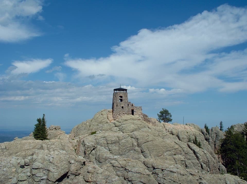
A rugged full-day loop to Black Elk Peak’s stone fire lookout.

Photo: Wikimedia Commons
Length
13.6mi
Time
8.5hr
Elev. change
2,083ft
Difficulty
Challenging
  • Loop
  • Dogs allowed
  • High point 7,152 ft
  • #15 of 40 in Custer
Parkwolf audio tour82 stories across Custer’s roads

Overview

About Black Elk Peak Loop via Lost Cabin and Trail #9 North

Why go

  • Stone fire lookout and open summit views
  • A varied circuit linking Lost Cabin and both #9 trails

Heads up

  • Long, rocky route with repeated climbing
  • Short road connector and junction require attention

Map & elevation

The route

Loading the Custer map
Full map
Elevation5,069–7,152 ft
TrailheadPalmer Creek Trailhead43.88655, -103.55407
Keep this map with you offline in the Parkwolf app

Plan your hike

Before you go

Parking

Start at Palmer Creek Trailhead. From Hill City, follow US 16 south about 3 miles, turn east on SD 244 toward Mount Rushmore for about 2.7 miles, then turn onto Palmer Creek Road just before Palmer Gulch Resort and continue about 1 mile to the trailhead on the left/east side. Parking capacity and fees were not verified.

Safety

Expect steep, rocky climbing and rocky switchbacks with large steps on Trail #9 North. The exposed summit can be colder and windier than the lower trail; conditions can change quickly. There is no potable water at Palmer Creek Trailhead. Follow the mapped line carefully at the short Trail #8 to road connector. Dogs must be leashed or under strict voice control.

A park ranger sits on a dash-mounted phone, talking, as Parkwolf’s Tour Guide plays “Army Cutworm Moths: A Grizzly Bear Buffet” on Grand Loop Road below Dunraven Pass in Yellowstone
Parkwolf Tour GuideThe highest, rockiest slopes around here are a summer buffet for grizzly bears.

Custer Tour Guide

Your drive to Black Elk Peak Loop via Lost Cabin and Trail #9 North, narrated.

Parkwolf is a GPS audio tour guide for Custer State Park. As you drive, it chimes in with what’s ahead: hidden gems, upcoming stops, history, geology, and wildlife, right through your car’s speakers.

More stories near here in the app

  • Why It’s Called Black Elk Peak
  • Sylvan Lake Lodge: A Meal Above the Lake
  • Little Devils Tower: The Summit Scramble
  • Sylvan Lake: Rocks and Water
  • 82 audio storiesacross Custer’s roads, triggered by GPS as you drive
  • Wildlife heatmapsfor Bison, Wapiti, Bighorn Sheep, and 13 more
  • Works offlinemaps, 40 trails, 49 places, and audio download before you lose signal
  • CarPlay readysimple controls built for the drive
★★★★★
“We recently toured Badlands, Custer State Park, Mount Rushmore and more! We learned so much from this app as we toured each of these sites. The audio tours are worth the money.”
milesdavis11App Store review
Download Parkwolf on the App StoreGet Parkwolf on Google Play

4.7 from 8,600+ ratings

Trail guide

Hiking Black Elk Peak Loop via Lost Cabin and Trail #9 North

The full circuitThe Black Elk Peak Loop via Lost Cabin is a hard 13.6-mile circuit from Palmer Creek Trailhead.

The Black Elk Peak Loop via Lost Cabin is a hard 13.6-mile circuit from Palmer Creek Trailhead. It follows Trail #2 to Trail #9 South, makes the required summit spur out and back, descends on Trail #9 North, then uses Trail #8, a short local-road connector and the north section of Lost Cabin to close the loop. Allow about 8–9 hours. The listed distance is the complete Palmer Creek circuit represented by this route; other accounts count different access points and connectors, so component-trail mileages are not the full hike. For a shorter summit outing, use a separate approach from Sylvan Lake.

Lost Cabin and the climbLost Cabin 2 rises steeply at first, then eases into a gradual descent with views toward Black…

Lost Cabin #2 rises steeply at first, then eases into a gradual descent with views toward Black Elk Peak. The climb resumes on #9 South, so the route asks for sustained effort rather than one climb followed by an easy walk out. Rocky footing can slow you down. The steepest stretch and junctions deserve attention, particularly where Trail #8 meets the short road connection on the return.

The summit and north descentBlack Elk Peak tops out at 7,242 feet.

Black Elk Peak tops out at 7,242 feet. A stone fire lookout marks the summit, where open granite gives broad views across the Black Hills. The peak was formerly called Harney Peak. From the summit spur, retrace to the #9 junction and take #9 North downhill; expect rocky switchbacks and large steps on this side.

Access and preparationPalmer Creek Trailhead is on Forest Service land outside Custer State Park’s mapped boundary,…

Palmer Creek Trailhead is on Forest Service land outside Custer State Park’s mapped boundary, and this loop follows a trail network across agency boundaries. From Hill City, go south on US 16 for about 3 miles, east on SD 244 for roughly 2.7 miles, turn onto Palmer Creek Road just before Palmer Gulch Resort, and continue about 1 mile to the trailhead on the left/east side. One toilet is listed at the trailhead, but its accessibility is unknown; there is no potable water. Carry what you need for a long day. The exposed summit can be colder and windier than the lower trail, and conditions have changed quickly on this mountain. Dogs are allowed on leash or under strict voice control.

Wildlife

Wildlife in Custer

All Custer wildlife maps

Sighting maps show where each species has been reported across Custer. Wildlife moves, so no sighting is guaranteed.

Keep exploring

Near Black Elk Peak Loop via Lost Cabin and Trail #9 North

See it all on the map

Trails that start nearby

Places near the trailhead

Parkwolf’s Custer ranking

Top-rated trails in Custer

All 40 trails
  1. 1Black Elk Peak Trail #9 SouthChallenging · 6.6 mi
  2. 2Cathedral Spires TrailChallenging · 1.2 mi
  3. 3Sunday Gulch TrailChallenging · 3 mi
  4. 4Little Devils Tower TrailChallenging · 3 mi
  5. 5Sylvan Lake Shore TrailModerate · 1 mi
  6. 6Black Elk Peak LoopChallenging · 7.1 mi

Take Parkwolf to Custer.

The audio tour guide for the drive, plus offline maps, trails, and wildlife heatmaps for when the signal drops.

4.7 from 8,600+ ratings

Download Parkwolf on the App StoreGet Parkwolf on Google Play