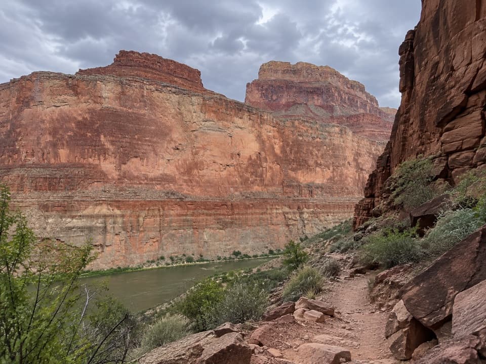
South Canyon Trail to the Colorado River in Grand Canyon National Park

Grand Canyon National Park, AZ

South Canyon Trail to the Colorado River

A rough Colorado River descent that needs a real exit plan.

Length
6.5mi
Time
7.3hr
Elev. change
2,694ft
Difficulty
Challenging
  • No dogs
  • High point 5,581 ft
Parkwolf audio tour79 stories across Grand Canyon’s roads

Overview

About South Canyon Trail to the Colorado River

Why go

  • A remote Colorado River beach beneath towering canyon walls
  • A cairned route through dryfalls and exposed rock layers

Heads up

  • Loose, rough travel with several mandatory downclimbs
  • A long dirt-road approach with rain-sensitive access

Map & elevation

The route

Loading the Grand Canyon map
Full map
Elevation2,887–5,581 ft
TrailheadSouth Canyon Trailhead36.47400, -111.92809
Keep this map with you offline in the Parkwolf app

Plan your hike

Before you go

Parking

From US 89A near mile marker 559.5, take House Rock Road (also marked FR 445 / 8910) for about 22 miles. At 10.7 miles keep left, avoiding the private Kane Ranch fork. At mile 18.8 turn left onto FR 632 (also marked 3510); after 1.9 miles turn right at the South Canyon Trail sign, cross the cattle guard and continue about a mile to the parking area at the canyon edge. Trailhead facilities and parking capacity were not established.

Safety

The rim descent is very steep and loose. Below it, there is little maintained tread, substantial route-finding, boulder hopping and cairned bypasses around dryfalls; the final descent includes a 12-foot climb-down. The drainage is usually dry, so carry enough water to reach the Colorado; river water may be silty and requires treatment. Rocks at Vasey’s Paradise slope toward the river and can be slippery. Pets are prohibited below the rim, overnight camping requires a backcountry permit, and the long dirt approach can become impassable during or just after rain.

4 active Grand Canyon alerts

  • ClosureInner Canyon and North Rim trail closuresDo not enter the closed trails, bridges, campgrounds, and inner-canyon areas.Official details
  • ClosureNorth Rim scenic roads closed for repairsCape Royal Road and Point Imperial Road are closed from sunset October 15 through sunrise November 3, 2026. - The roads are closed to accommodate critical road repair and rehabilitation work.Official details
See all 4 alerts
A park ranger sits on a dash-mounted phone, talking, as Parkwolf’s Tour Guide plays “Army Cutworm Moths: A Grizzly Bear Buffet” on Grand Loop Road below Dunraven Pass in Yellowstone
Parkwolf Tour GuideThe highest, rockiest slopes around here are a summer buffet for grizzly bears.

Grand Canyon Tour Guide

Your drive to South Canyon Trail to the Colorado River, narrated.

Parkwolf is a GPS audio tour guide for Grand Canyon National Park. As you drive, it chimes in with what’s ahead: hidden gems, upcoming stops, history, geology, and wildlife, right through your car’s speakers.

See the Grand Canyon audio tour
  • 79 audio storiesacross Grand Canyon’s roads, triggered by GPS as you drive
  • Wildlife heatmapsfor California Condor, Bighorn Sheep, American Bison, and 13 more
  • Works offlinemaps, 73 trails, 96 places, and audio download before you lose signal
  • CarPlay readysimple controls built for the drive
★★★★★
“Fantastic app with many points of information… It’s great to just turn on while you’re driving and it gives you an audio tour of the national Park. We love it!!!!”
JMJamesApp Store review
Download Parkwolf on the App StoreGet Parkwolf on Google Play

4.7 from 8,600+ ratings

Trail guide

Hiking South Canyon Trail to the Colorado River

A serious river descentSouth Canyon Trail to the Colorado River is a remote 6.

South Canyon Trail to the Colorado River is a remote 6.5-mile point-to-point route from Marble Bench's rim to a river beach. Allow about 7 to 8 hours one way; it drops roughly 2,700 feet, and much of the route is cairned, loose canyon travel rather than a built trail. There is no road at the river. Unless your river itinerary has a confirmed pickup, return the same way: about 13 miles and 14 hours in all, an exceptional day. Overnight camping below the rim requires a backcountry permit; day hikes do not.

Down from the rimFrom the parking area, follow the rim southwest for about 90 yards to a cairned chute.

From the parking area, follow the rim southwest for about 90 yards to a cairned chute. Tight switchbacks and short loose-rock downclimbs lead to a limestone outcrop, then the route traverses toward a red-and-white slickrock gully and drops by more steep switchbacks to the canyon floor. The official one-way mileage is a guide; the exact line varies through the rough drainage.

Through the dry drainageBelow the rim, expect boulder hopping, brush and route-finding for the easiest line down the…

Below the rim, expect boulder hopping, brush and route-finding for the easiest line down the wash. Two 15- to 20-foot pour-offs are bypassed on cairned routes along the south, or right, side. After Bedrock Canyon joins from the north, a 40-foot dryfall comes about 125 yards downstream. Its cairned shelf bypass runs roughly 220 yards along the south side before dropping back into the creek bed.

The river and the RedwallAt the gray Redwall Limestone narrows, cairns climb around the north side over loose ground and…

At the gray Redwall Limestone narrows, cairns climb around the north side over loose ground and small ravines, then cross the Supai layer. The view opens toward the Colorado and Vasey's Paradise. A steep final descent includes a 12-foot climb-down to a ledge, a shelf above the river and a scramble through a break in the limestone to the beach. Raft parties often use the beach's lower end; the upper stretch is narrower. From the shore, include foreground boulders with the river and high walls to show the canyon's scale. Rocks at Vasey's Paradise can be slick and slope toward the river.

A cave, a name and old layersThe Redwall here is naturally gray, despite its name.

The Redwall here is naturally gray, despite its name. The route crosses the Supai layer before the river view. Vasey's Paradise was named in 1869 for a botanist who traveled with Powell through the Rocky Mountains the year before. Gated Stanton's Cave has yielded 4,000-year-old split-twig figures and remains of a giant teratorn, an extinct condor-like bird with a wingspan of about 12 feet. Leave the cave closed and archaeological material alone.

Road and water planningThe approach is about 22 miles of dirt road from US 89A, so rain can make the drive impassable.

The approach is about 22 miles of dirt road from US 89A, so rain can make the drive impassable. The canyon is usually dry; carry enough water to reach the Colorado. River water may be silty and needs settling before treatment, with a backup purification method. Pets are not allowed below the rim. No trailhead water, toilets or food service were confirmed.

Wildlife

Wildlife in Grand Canyon

All Grand Canyon wildlife maps

Sighting maps show where each species has been reported across Grand Canyon. Wildlife moves, so no sighting is guaranteed.

Parkwolf’s Grand Canyon ranking

Top-rated trails in Grand Canyon

All 73 trails
  1. 1Rim-to-Rim: North Kaibab to Bright AngelChallenging · 23.5 mi
  2. 2South Kaibab TrailChallenging · 6.3 mi
  3. 3Bright Angel TrailChallenging · 7.8 mi
  4. 4Rim TrailModerate · 12.8 mi
  5. 5Rim-to-Rim: South Kaibab to North KaibabChallenging · 21 mi
  6. 6Cape Royal TrailEasy · 0.8 mi

Take Parkwolf to Grand Canyon.

The audio tour guide for the drive, plus offline maps, trails, and wildlife heatmaps for when the signal drops.

4.7 from 8,600+ ratings

Download Parkwolf on the App StoreGet Parkwolf on Google Play