Shadow Mountain Lookout Trail in Rocky Mountain National Park

Rocky Mountain National Park, CO

Shadow Mountain Lookout Trail

A lakeside route climbs to a historic lookout closed to hikers.

Photo: Public Domain
Length
9.6mi
Time
4.5hr
Elev. change
1,503ft
Difficulty
Challenging
  • No dogs
  • High point 9,875 ft
  • #55 of 136 in Rocky Mountain

Hear the audio tour

Water Beneath the Mountains

Overview

About Shadow Mountain Lookout Trail

Why go

  • A long lakeshore approach leads to a rare historic fire lookout.
  • The mostly level first stretch gives way to a steady forest climb.

Heads up

  • A 9.6-mile return at nearly 10,000 feet is a substantial day hike.
  • The tower is closed, and the ground-level view is tree-screened.

Map & elevation

The route

Loading the Rocky Mountain map
Full map
Elevation8,373–9,875 ft
TrailheadEast Shore Trailhead40.24027, -105.82551
Keep this map with you offline in the Parkwolf app

Plan your hike

Before you go

Parking

Start at East Shore Trailhead on the Grand Lake side of Shadow Mountain Lake; the alternate Shadow Mountain Dam access is a different starting point. Current fee and lot-capacity details for this specific lot were not reliably confirmed, so check the posted rules.

Best time to go

East Shore Trailhead is in Arapaho National Recreation Area; check the posted parking rules at the lot. The route crosses into Rocky Mountain National Park, where pets are prohibited on trails. Each winter, portions of East Shore Trail close from November 15 through March 15 to protect bald eagles; the footprint can change, so check the current closure map before a winter hike. Restrooms and drinking water at the trailhead or along the route were not confirmed.

Safety

The climb reaches nearly 10,000 feet. The historic tower is closed to hikers; do not climb or enter it. Portions of East Shore Trail close each year from November 15 through March 15 for bald eagle protection, and the footprint can change; check the current closure map before a winter hike.

3 active Rocky Mountain alerts

  • ClosureOld Fall River Road closed to vehiclesOld Fall River Road is closed to motor vehicles for the season.Official details
  • ClosureSun Valley burn-area access remains closedThe area and trail west of Sun Valley Trail remain closed, including the route used for angler access to the Colorado River, because of impacts from the 2020 East Troublesome and Cameron Peak Fires;…Official details
See all 3 alerts
A park ranger sits on a dash-mounted phone, talking, as Parkwolf’s Tour Guide plays “Army Cutworm Moths: A Grizzly Bear Buffet” on Grand Loop Road below Dunraven Pass in Yellowstone
Parkwolf Tour GuideThe highest, rockiest slopes around here are a summer buffet for grizzly bears.

Rocky Mountain Tour Guide

Your drive to Shadow Mountain Lookout Trail, narrated.

Parkwolf is a GPS audio tour guide for Rocky Mountain National Park. As you drive, it chimes in with what’s ahead: hidden gems, upcoming stops, history, geology, and wildlife, right through your car’s speakers.

See the Rocky Mountain audio tour

Recorded for this area

Water Beneath the Mountains
0:00 / 0:31
“Near Grand Lake, water enters a thirteen-mile tunnel beneath the mountains and emerges near Estes Park. The Alva B.”

Plays on the road 0.9 mi from the trailhead in the Parkwolf Rocky Mountain Tour Guide.

More stories near here in the app

  • North Inlet: The Walk to Cascade Falls
  • East Inlet: Two Views of Adams Falls
  • Kawuneeche Visitor Center: Get Your Bearings
  • Harbison Meadows: Lunch at the Sisters' Ranch
  • 79 audio storiesacross Rocky Mountain’s roads, triggered by GPS as you drive
  • Wildlife heatmapsfor Elk, Moose, Mountain Goat, and 13 more
  • Works offlinemaps, 136 trails, 88 places, and audio download before you lose signal
  • CarPlay readysimple controls built for the drive
★★★★★
“…No cell service for majority of the day but had continuous access to the app - the maps, the tour guide as you drive is amazing. Highly recommend purchasing the subscription.”
jkatnerApp Store review
Download Parkwolf on the App StoreGet Parkwolf on Google Play

4.7 from 8,600+ ratings

Trail guide

Hiking Shadow Mountain Lookout Trail

A long walk to a historic lookoutShadow Mountain Lookout Trail is a 9.

Shadow Mountain Lookout Trail is a 9.6-mile out-and-back from East Shore Trailhead to the historic fire lookout above Shadow Mountain Lake. The mapped route is about 4.8 miles each way, with roughly 1,530 feet of climbing; allow at least four to five hours. It is a substantial high-elevation hike, not a quick lake stroll. The tower is closed to hikers, so the destination is its exterior, not a climb to the elevated lookout platform.

Shoreline first, forest climb afterThe first roughly 1.

The first roughly 1.5 miles follow East Shore Trail beside Shadow Mountain Lake on mostly level ground, with intermittent water views. At the fork, take the left branch toward the lookout; the other branch continues toward Shadow Mountain Dam. From there the path climbs steadily through forest, mostly under tree cover, with a couple of short open viewpoints. Turn around at the historic lookout and return the same way. Osprey nest near the shore, though a sighting is never guaranteed.

The tower and its historyThe three-story stone-and-timber lookout was built by the Civilian Conservation Corps in 1933…

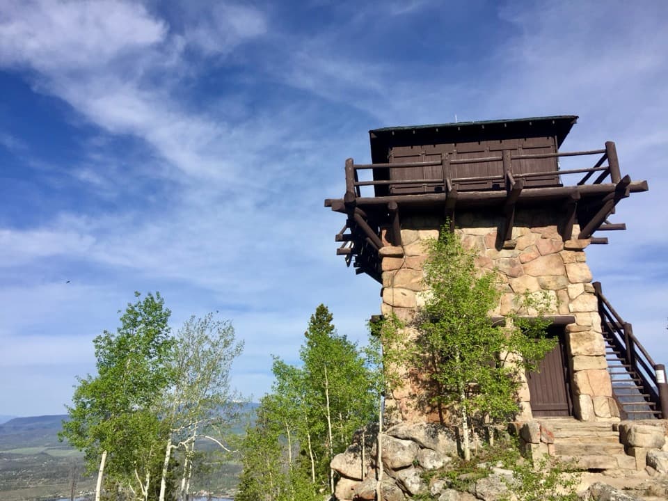
The three-story stone-and-timber lookout was built by the Civilian Conservation Corps in 1933 and staffed through the 1968 season. It was added to the National Register of Historic Places in 1978 and restored in the mid-1990s. You can see the structure from outside, but do not climb or enter it. Trees screen much of the ground-level view, so do not plan on the broad panorama described from the tower platform.

Wildlife

Wildlife in Rocky Mountain

All Rocky Mountain wildlife maps

Sighting maps show where each species has been reported across Rocky Mountain. Wildlife moves, so no sighting is guaranteed.

Keep exploring

Near Shadow Mountain Lookout Trail

See it all on the map

Trails that start nearby

Places near the trailhead

Parkwolf’s Rocky Mountain ranking

Top-rated trails in Rocky Mountain

All 136 trails
  1. 1Emerald Lake TrailModerate · 3.4 mi
  2. 2Sky Pond TrailChallenging · 9 mi
  3. 3Chasm Lake TrailChallenging · 8.4 mi
  4. 4Bear Lake LoopEasy · 0.6 mi
  5. 5Dream Lake TrailModerate · 2.2 mi
  6. 6Alberta Falls TrailEasy · 1.7 mi

Take Parkwolf to Rocky Mountain.

The audio tour guide for the drive, plus offline maps, trails, and wildlife heatmaps for when the signal drops.

4.7 from 8,600+ ratings

Download Parkwolf on the App StoreGet Parkwolf on Google Play