South River Falls

Third‑tallest falls with overlook and rewarding rugged base access
South River Falls, Shenandoah National Park
InsideShenandoah National Park

Overview

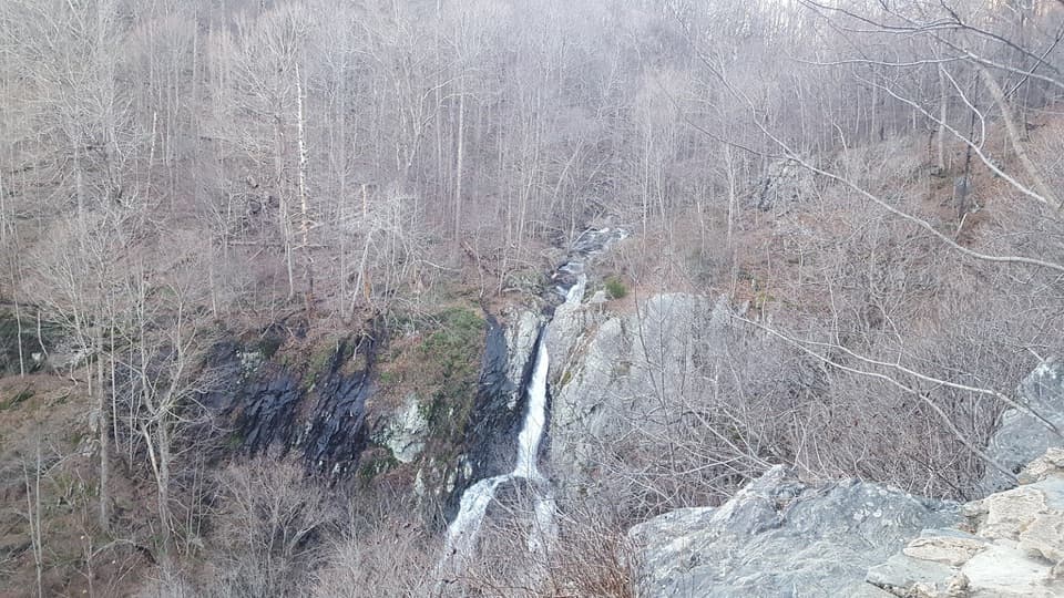
South River Falls delivers one of the park’s classic waterfall payoffs: an 83‑foot drop tucked in lush forest, reached from the South River Picnic Area (around mile 62.7–62.8 on Skyline Drive). It’s popular without feeling overrun, especially compared to the headline falls.

The Hike

Most people do a 3.3‑mile circuit (about 910 feet of elevation gain). Follow the blue‑blazed South River Falls Trail from the picnic area. About 1.3–1.4 miles in, a stone‑walled overlook offers a distant view of the falls. For the close‑up, continue down a narrower, rockier path to the base, where there’s a shallow pool and room to sit on streamside rocks. The loop commonly returns via the South River Fire Road and a short stretch of the Appalachian Trail. Expect one stream crossing and footing that can be slick after rain.

What Makes It Different

You get both an overhead perspective and a face‑to‑face view of one of the park’s tallest waterfalls on a single outing. The base is the money view—worth the extra effort—while the overlook gives context for the falls’ setting in the gorge.

Wildlife

This drainage is a standout for breeding warblers (cerulean, Blackburnian, black‑throated blue), plus northern parula, Louisiana waterthrush, vireos, scarlet tanager, and rose‑breasted grosbeak. Butterflies like spicebush and pipevine swallowtails turn up in season. White‑tailed deer are common; bobcat and black bear are possible but less frequently seen. Bring binoculars if you’re a birder.

Season and Water Flow

The falls shine in spring and after rains. Late summer and early fall can run low during dry spells, changing the feel (and your photos) considerably. Bugs—ticks and mosquitoes—are more active in warmer months.

Best Time to Visit

  • Time of day: Mornings or mid‑week for easier parking and quieter trails.
  • Season: Spring and post‑rain periods for the strongest flow.
  • Photography: Soft morning light at the base; bring a tripod for silky water shots.

Logistics & Need‑to‑Know

  • Start: South River Picnic Area; trailhead is by the comfort station. Parking and restrooms are here, but there are no services along the trail or at the falls.
  • Route options: Out‑and‑back to the overlook or base, or the 3.3‑mile circuit using the fire road/AT for a more gradual exit.
  • Conditions: Expect a rocky spur to the base, a stream crossing, and a steady uphill return. Sturdy shoes help.
  • Pets: Allowed on leash (6 ft max).
  • Entry: Park entrance fee applies.

If you only stop at the overlook, you’ll miss the best part—commit to the final descent if you have the legs for the climb back.

Pros

  • Third‑tallest waterfall in the park at 83 feet
  • Two vantage points: overlook and rugged spur to the base

Cons

  • Steep climb back from the river makes the return strenuous
  • Overlook is distant; best views require the rocky spur to the base
  • Flow can be weak in late‑summer dry spells

Tips

  • Park at South River Picnic Area and hit the trail early to avoid crowds.
  • For the best view, continue past the overlook on the rocky spur to the base.
  • Visit in spring or after rain; late summer flow can be underwhelming.
  • Return via the South River Fire Road/AT segment for a more gradual climb out.
  • Expect one stream crossing and slick rocks—wear sturdy shoes and bring bug spray.
The Parkwolf tour guide sitting on a phone mounted in a car

Parkwolf Tour Guide

Like a tour guide in your car.

Save the places you found around Shenandoah, then let Parkwolf guide the drive between them.Download Parkwolf on the App Store