Gypsum Sinkhole in Capitol Reef National Park

Sight · Capitol Reef National Park

Gypsum Sinkhole

A 200-foot sinkhole worth adding to a Cathedral Valley loop.

Type
Sight
Nearest trail
0.1 mi
Audio stories
5 nearby
  • Parking
  • Scenic viewpoint
  • #21 of 45 sights

Hear the audio tour

Gypsum Sinkhole

Overview

About Gypsum Sinkhole

Why stop

  • A striking, nearly 200-foot-deep collapse pit

Heads up

  • A long, rough high-clearance drive for a brief stop

Map

Where it is

Loading the Capitol Reef map
Full map
SightGypsum Sinkhole38.49835, -111.31947
Keep this map with you offline in the Parkwolf app

Plan your stop

Before you go

2 active Capitol Reef alerts

  • CautionE. coli advisory for Fremont River and Sulphur CreekMentions Fremont River, referenced in this guideDo not swim in the Fremont River or Sulphur Creek or get water in your mouth: NPS reports elevated E. coli in both waterways, and Utah DEQ has issued a warning advisory. - DEQ reports Sulphur Creek E.Official details
  • CautionFlash-flood hazard in canyons and washesHeavy rains can cause sudden flooding in Capitol Reef’s canyons and washes; do not hike or drive through floodwater.Official details

Capitol Reef alerts
A park ranger sits on a dash-mounted phone, talking, as Parkwolf’s Tour Guide plays “Army Cutworm Moths: A Grizzly Bear Buffet” on Grand Loop Road below Dunraven Pass in Yellowstone
Parkwolf Tour GuideThe highest, rockiest slopes around here are a summer buffet for grizzly bears.

Capitol Reef Tour Guide

Your drive to Gypsum Sinkhole, narrated.

Parkwolf is a GPS audio tour guide for Capitol Reef National Park. As you drive, it chimes in with what’s ahead: hidden gems, upcoming stops, history, geology, and wildlife, right through your car’s speakers.

See the Capitol Reef audio tour

Recorded for this place

Gypsum Sinkhole
0:00 / 0:27
“Gypsum Sinkhole is coming up, with a short walk to a hole nearly two hundred feet deep.”

Plays as you drive up to Gypsum Sinkhole in the Parkwolf Capitol Reef Tour Guide.

More stories near here in the app

  • Watch the Raven's Next Move
  • How to Copy an Apple Tree
  • Moccasins with Dewclaws
  • Cathedrals Trail
  • 116 audio storiesacross Capitol Reef’s roads, triggered by GPS as you drive
  • Wildlife heatmapsfor Bighorn Sheep, Mule Deer, Marmot, and 13 more
  • Works offlinemaps, 48 trails, 52 places, and audio download before you lose signal
  • CarPlay readysimple controls built for the drive
★★★★★
“Fantastic app with many points of information… It’s great to just turn on while you’re driving and it gives you an audio tour of the national Park. We love it!!!!”
JMJamesApp Store review
Download Parkwolf on the App StoreGet Parkwolf on Google Play

4.7 from 8,600+ ratings

Guide

More about Gypsum Sinkhole

Make this a Cathedral Valley stopGypsum Sinkhole is a geologic stop in the Cathedral District: a nearly 50-foot-wide collapse…

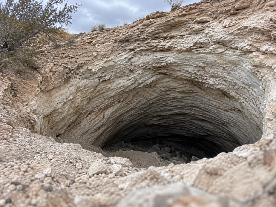
Gypsum Sinkhole is a geologic stop in the Cathedral District: a nearly 50-foot-wide collapse pit that drops about 200 feet into layered rock. I'd stop if I'm already making the remote valley drive; I wouldn't make this the only reason for going. It's a striking, short visit after a long stretch of rough road.

Budget for the driveFrom the Highway 24 junction, the sinkhole is 25.

From the Highway 24 junction, the sinkhole is 25.6 miles along Cathedral Road on the counterclockwise route. The full loop is 57.6 miles and usually takes six to eight hours. High clearance is required, and 4WD may be needed depending on conditions. Rain, snow and washouts can make the dirt roads impassable. The return leg on Hartnet Road crosses the Fremont River at an unbridged ford; check its condition and don't cross during high water. There is no potable water in Cathedral Valley.

How the hole formedGroundwater dissolved a buried plug of gypsum and left a cavity.

Groundwater dissolved a buried plug of gypsum and left a cavity. The overlying rock collapsed into it, exposing the curved layers around the opening. It is a reminder that the red-rock landscape has softer, easily dissolved material hidden inside it.

Take in the whole curveThe layered bowl is the view, and the park identifies this as a scenic photo stop.

The layered bowl is the view, and the park identifies this as a scenic photo stop. Frame the curved rim as well as the dark center to show the sinkhole's scale. Keep well back: the rock around the edge is soft and unstable and can collapse without warning.

Wildlife

Wildlife in Capitol Reef

All Capitol Reef wildlife maps

Sighting maps show where each species has been reported across Capitol Reef. Wildlife moves, so no sighting is guaranteed.

Parkwolf’s Capitol Reef ranking

Top sights in Capitol Reef

All 52 places
  1. 1Hickman BridgeSight
  2. 2Gifford HomesteadSight
  3. 3Fremont PetroglyphsSight
  4. 4Cassidy ArchSight
  5. 5Temples of the Sun and MoonSight
  6. 6Fruita OrchardsSight

Take Parkwolf to Capitol Reef.

The audio tour guide for the drive, plus offline maps, trails, and wildlife heatmaps for when the signal drops.

4.7 from 8,600+ ratings

Download Parkwolf on the App StoreGet Parkwolf on Google Play