Sandstone Falls in New River Gorge National Park

#2 of 39 sights in New River Gorge

Sight · New River Gorge National Park

Sandstone Falls

A short boardwalk reaches islands framed by 1,500 feet of low falls.

Photo: Wikimedia Commons
Type
Sight
Nearest trail
0.1 mi
Audio stories
9 nearby
  • Trailhead
  • Parking
  • Restrooms
  • Exhibit

Hear the audio tour

Sandstone Falls and the Islands

Overview

About Sandstone Falls

Why stop

  • Easy boardwalk access to two distinct views of the falls.

Heads up

  • The long, narrow river-road drive is a lot for a short visit.

Map

Where it is

Loading the New River Gorge map
Full map
SightSandstone Falls37.75803, -80.90536
Keep this map with you offline in the Parkwolf app

Plan your stop

Before you go

5 active New River Gorge alerts

  • ClosureRend and Church Loop trails closedRend Trail is closed from both trailheads through approximately December 2027; Church Loop Trail is also closed because its only access is from Rend.Official details
  • ClosureKaymoor Miners Trail weekday closureThe upper Kaymoor Miners Trail is closed Monday–Thursday through November 19 for trail rehabilitation.Official details
See all 5 alerts
A park ranger sits on a dash-mounted phone, talking, as Parkwolf’s Tour Guide plays “Army Cutworm Moths: A Grizzly Bear Buffet” on Grand Loop Road below Dunraven Pass in Yellowstone
Parkwolf Tour GuideThe highest, rockiest slopes around here are a summer buffet for grizzly bears.

New River Gorge Tour Guide

Your drive to Sandstone Falls, narrated.

Parkwolf is a GPS audio tour guide for New River Gorge National Park. As you drive, it chimes in with what’s ahead: hidden gems, upcoming stops, history, geology, and wildlife, right through your car’s speakers.

See the New River Gorge audio tour

Recorded for this place

Sandstone Falls and the Islands
0:00 / 0:34
“Sandstone Falls is coming up, where the New River spreads into cascades across roughly fifteen hundred feet.”

Plays as you drive up to Sandstone Falls in the Parkwolf New River Gorge Tour Guide.

More stories near here in the app

  • Sandstone Falls from Above
  • The Woodpecker’s Rectangles
  • Where the New River Goes
  • Brooks Island and the Eagles
  • 92 audio storiesacross New River Gorge’s roads, triggered by GPS as you drive
  • Wildlife heatmapsfor Black Bear, White-tailed Deer, Pileated Woodpecker, and 13 more
  • Works offlinemaps, 49 trails, 55 places, and audio download before you lose signal
  • CarPlay readysimple controls built for the drive
★★★★★
“Fantastic app with many points of information… It’s great to just turn on while you’re driving and it gives you an audio tour of the national Park. We love it!!!!”
JMJamesApp Store review
Download Parkwolf on the App StoreGet Parkwolf on Google Play

4.7 from 8,600+ ratings

Guide

More about Sandstone Falls

Make time for the boardwalkSandstone Falls is a broad, low waterfall on the New River near Hinton, where islands split the…

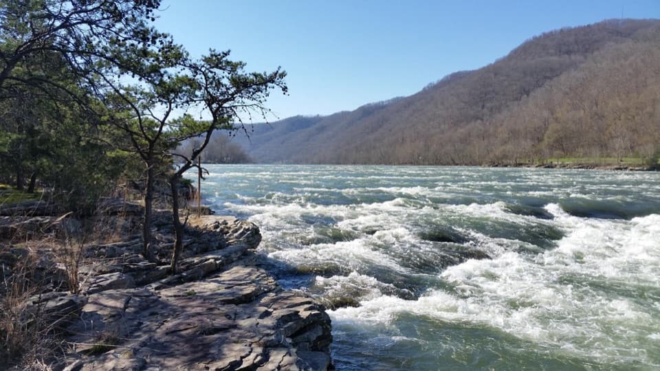
Sandstone Falls is a broad, low waterfall on the New River near Hinton, where islands split the river into cascades across roughly 1,500 feet. It’s one of the park’s signature stops, and the short boardwalk is the way to see both the lower falls and the main falls. Give the river-road drive enough time; the visit itself can be short.

Walk out to both islandsAn accessible boardwalk crosses two bridges to viewing decks on the islands. Plan on about 0.

An accessible boardwalk crosses two bridges to viewing decks on the islands. Plan on about 0.2 mile each way. The first island faces the lower falls; continue to the second for the main falls. The optional Island Loop adds an easy half-mile walk over natural ground, which can be muddy or rocky. It’s a real trail, not more boardwalk.

For a photo, work with the width of the falls: frame the separate cascades across the river instead of cropping in on one patch of water. The amount of whitewater changes with river levels, so the scene can look quite different from one visit to the next.

A waterfall cut into a sandstone ledgeThe river spreads across the islands and drops about 10 to 25 feet.

The river spreads across the islands and drops about 10 to 25 feet. This is a long series of low cascades, not one tall plunge. Hard Stony Gap sandstone makes the ledge; softer rock below it erodes first, undercutting the shelf until sections break away. That slow process moves the falls upstream.

The mill channel and the island’s pastThe first bridge crosses a man-made channel that once carried water to a gristmill, where local…

The first bridge crosses a man-made channel that once carried water to a gristmill, where local corn and wheat were ground. The larger island was farmed, grazed and timbered. Its old fields are gradually growing back into forest.

A rare riverside plant communityThe first island supports an Appalachian Riverside Flatrock Community, a rare group of plants…

The first island supports an Appalachian Riverside Flatrock Community, a rare group of plants adapted to exposed sandstone that floods scour clean. Lichens and mosses start building thin soil; small plants take hold, followed over time by eastern red cedar, scrub pine and post oak. The community occurs at only a handful of West Virginia river sites. Dams upstream have reduced flood intensity, and the long-term effect on this habitat is still unknown.

The drive and the practical detailsFrom Sandstone Visitor Center, allow about 45 minutes by way of WV-20 through Hinton and…

From Sandstone Visitor Center, allow about 45 minutes by way of WV-20 through Hinton and WV-26/New River Road. The final stretch is narrow, has no center line and gives drivers little room to pass; vehicles over 25 feet, including RVs, aren’t recommended. The day-use area has parking, a restroom and interpretive information. There’s no food service at the falls; the picnic area at Brooks Falls is a separate stop on the drive. Sandstone Falls Overlook is also separate: it’s the high roadside viewpoint on WV-20, while this place is the riverside boardwalk. The New River runs fast and its level changes, so stay on the boardwalk and established trails.

Wildlife

Wildlife in New River Gorge

All New River Gorge wildlife maps

Sighting maps show where each species has been reported across New River Gorge. Wildlife moves, so no sighting is guaranteed.

Parkwolf’s New River Gorge ranking

Top sights in New River Gorge

All 55 places
  1. 1New River Gorge BridgeSight
  2. 3Grandview Main OverlookSight
  3. 4Diamond Point OverlookSight
  4. 5Long Point OverlookSight
  5. 6Nuttallburg Historic SiteSight
  6. 7Thurmond Historic DistrictSight

Take Parkwolf to New River Gorge.

The audio tour guide for the drive, plus offline maps, trails, and wildlife heatmaps for when the signal drops.

4.7 from 8,600+ ratings

Download Parkwolf on the App StoreGet Parkwolf on Google Play