New River Gorge Bridge in New River Gorge National Park

#1 of 39 sights in New River Gorge

Sight · New River Gorge National Park

New River Gorge Bridge

A 3,030-foot steel arch above a river 876 feet below.

Photo: Wikimedia Commons
Type
Sight
Nearest trail
0.4 mi
Audio stories
15 nearby
  • Scenic viewpoint
  • Visitor center
  • Parking
  • Restrooms

Hear the audio tour

Canyon Rim and the Bridge

Overview

About New River Gorge Bridge

Why stop

  • A full steel arch, river and wooded gorge in one view

Heads up

  • You cannot walk the highway deck on an ordinary day

Map

Where it is

Loading the New River Gorge map
Full map
SightNew River Gorge Bridge38.06874, -81.08294
Keep this map with you offline in the Parkwolf app

Plan your stop

Before you go

5 active New River Gorge alerts

  • ClosureRend and Church Loop trails closedRend Trail is closed from both trailheads through approximately December 2027; Church Loop Trail is also closed because its only access is from Rend.Official details
  • ClosureKaymoor Miners Trail weekday closureThe upper Kaymoor Miners Trail is closed Monday–Thursday through November 19 for trail rehabilitation.Official details
See all 5 alerts
A park ranger sits on a dash-mounted phone, talking, as Parkwolf’s Tour Guide plays “Army Cutworm Moths: A Grizzly Bear Buffet” on Grand Loop Road below Dunraven Pass in Yellowstone
Parkwolf Tour GuideThe highest, rockiest slopes around here are a summer buffet for grizzly bears.

New River Gorge Tour Guide

Your drive to New River Gorge Bridge, narrated.

Parkwolf is a GPS audio tour guide for New River Gorge National Park. As you drive, it chimes in with what’s ahead: hidden gems, upcoming stops, history, geology, and wildlife, right through your car’s speakers.

See the New River Gorge audio tour

Recorded for this place

Canyon Rim and the Bridge
0:00 / 0:32
“You're approaching the turnoff for Canyon Rim Visitor Center. This is the stop I'd choose for a full view of the New River Gorge Bridge without a long hike.”

Plays as you drive up to New River Gorge Bridge in the Parkwolf New River Gorge Tour Guide.

More stories near here in the app

  • Fayette Station and the Boxer's Bridge
  • The Heron That Uses Bait
  • Burnwood's Picnic Area and Old Trees
  • Bridge Walk Beneath the Highway
  • 92 audio storiesacross New River Gorge’s roads, triggered by GPS as you drive
  • Wildlife heatmapsfor Black Bear, White-tailed Deer, Pileated Woodpecker, and 13 more
  • Works offlinemaps, 49 trails, 55 places, and audio download before you lose signal
  • CarPlay readysimple controls built for the drive
★★★★★
“Fantastic app with many points of information… It’s great to just turn on while you’re driving and it gives you an audio tour of the national Park. We love it!!!!”
JMJamesApp Store review
Download Parkwolf on the App StoreGet Parkwolf on Google Play

4.7 from 8,600+ ratings

Guide

More about New River Gorge Bridge

The main viewThe New River Gorge Bridge is a 3,030-foot steel arch carrying U.S.

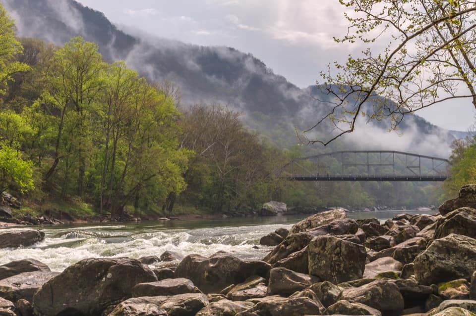
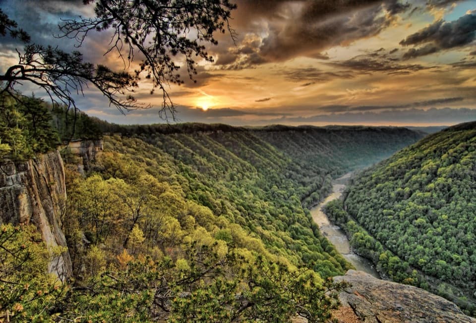
The New River Gorge Bridge is a 3,030-foot steel arch carrying U.S. Route 19 across the gorge, 876 feet above the New River. It is the park’s defining engineering landmark, and the easiest full-span view is from the adjacent Canyon Rim Visitor Center. From there, a short boardwalk reaches two overlooks where the arch, river and wooded gorge line up in one view. This is a bridge to look at on an ordinary day, not a pedestrian crossing; do not stop on its highway deck.

Choose your angleThe upper Canyon Rim deck has an accessible ramp; the lower deck is reached by stairs.

The upper Canyon Rim deck has an accessible ramp; the lower deck is reached by stairs. The visitor center has parking, flush restrooms, potable water, picnic tables and a small book and publication sales area. For a lower view, Fayette Station Road descends beneath the bridge to river level, with several pullouts along the way. It is an 8-mile one-way drive that usually takes 30 to 45 minutes, so treat it as a separate outing rather than a quick stop. Vehicles taller than 12 feet cannot complete the route, and large RVs and trailers are discouraged because of tight turns and low railroad clearance.

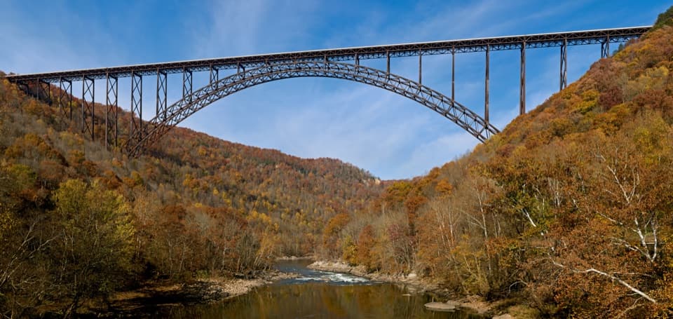
Look up from belowFayette Station Road gives you the other scale of the bridge: the arch and supports rise…

Fayette Station Road gives you the other scale of the bridge: the arch and supports rise directly above the narrow road and river. A separate guided Bridge Walk tour uses the maintenance catwalk beneath the roadway; it is not the same as walking across the bridge. The boardwalk decks at Canyon Rim are the simplest place to photograph the full arch with the river below, while the Fayette Station pullouts give you a closer, upward view.

A shortcut through the gorgeBefore the bridge opened on October 22, 1977, getting from one side of the gorge to the other…

Before the bridge opened on October 22, 1977, getting from one side of the gorge to the other meant a winding mountain-road drive that could take about 40 minutes. The bridge cut that crossing to less than a minute. It still carries U.S. 19 traffic, so the bridge itself is part of the route through the park as much as a landmark to stop and see.

How they built itThe single arch spans 1,700 feet.

The single arch spans 1,700 feet. Construction began with steel placed in 1974 using trolleys that ran on cables stretched 3,500 feet between towers. Michael Baker Company designed the bridge and American Bridge Division of U.S. Steel built it. Its Cor-ten weathering steel develops a rust-colored surface and was chosen so the structure would not need painting; the whole bridge weighs about 88 million pounds.

Records and recognitionWhen it opened, its arch was the world’s longest steel arch; it held that title until…

When it opened, its arch was the world’s longest steel arch; it held that title until Shanghai’s Lupu Bridge opened in 2003. It remains the longest steel arch bridge in the United States and is the country’s third-highest bridge. West Virginia put the bridge on its state commemorative quarter in 2006, and it entered the National Register of Historic Places in 2013.

Bridge Day is the exceptionBridge Day began in 1980 with five parachutists.

Bridge Day began in 1980 with five parachutists. It is now the annual exception to normal access: on the third Saturday in October, the roadway opens to pedestrians for jumping, rappelling, vendors and music. Event traffic and access details vary, so use current event information if you are planning around that day.

Wildlife

Wildlife in New River Gorge

All New River Gorge wildlife maps

Sighting maps show where each species has been reported across New River Gorge. Wildlife moves, so no sighting is guaranteed.

Keep exploring

Near New River Gorge Bridge

See it all on the map

Trails nearby

More stops nearby

Parkwolf’s New River Gorge ranking

Top sights in New River Gorge

All 55 places
  1. 2Sandstone FallsSight
  2. 3Grandview Main OverlookSight
  3. 4Diamond Point OverlookSight
  4. 5Long Point OverlookSight
  5. 6Nuttallburg Historic SiteSight
  6. 7Thurmond Historic DistrictSight

Take Parkwolf to New River Gorge.

The audio tour guide for the drive, plus offline maps, trails, and wildlife heatmaps for when the signal drops.

4.7 from 8,600+ ratings

Download Parkwolf on the App StoreGet Parkwolf on Google Play