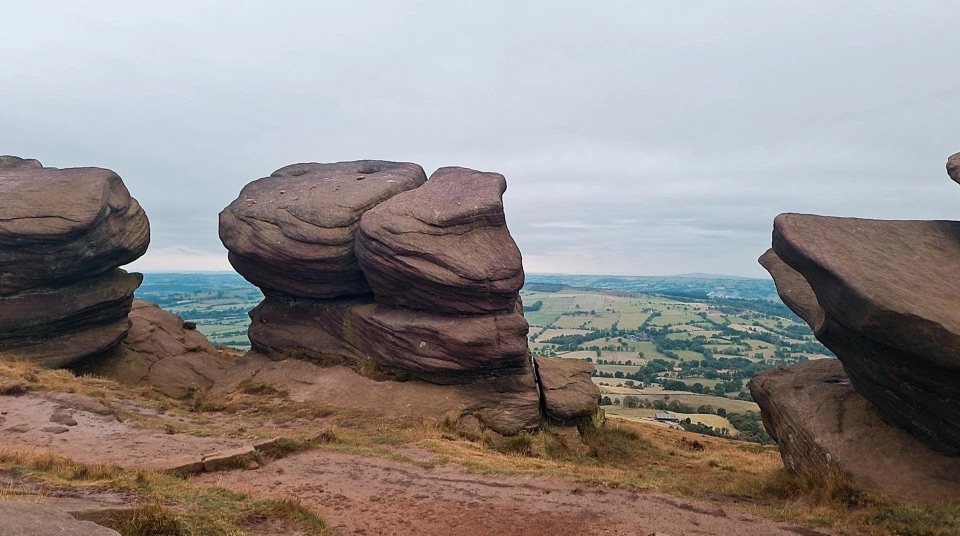
The Roaches in Peak District National Park

Sight · Peak District National Park

The Roaches

Gritstone ridge of stacked crags, heather moor and wide valley views

Photo: Wikimedia Commons
Type
Sight
Nearest trail
2.2 km
Audio stories
7 nearby
  • Parking
  • Scenic viewpoint
  • #27 of 69 sights

Hear the audio tour

The Roaches and Lud’s Church

Overview

About The Roaches

Why stop

  • Distinctive stacked gritstone crags and wide valley views

Heads up

  • Rough, exposed footing that turns slick in wet weather
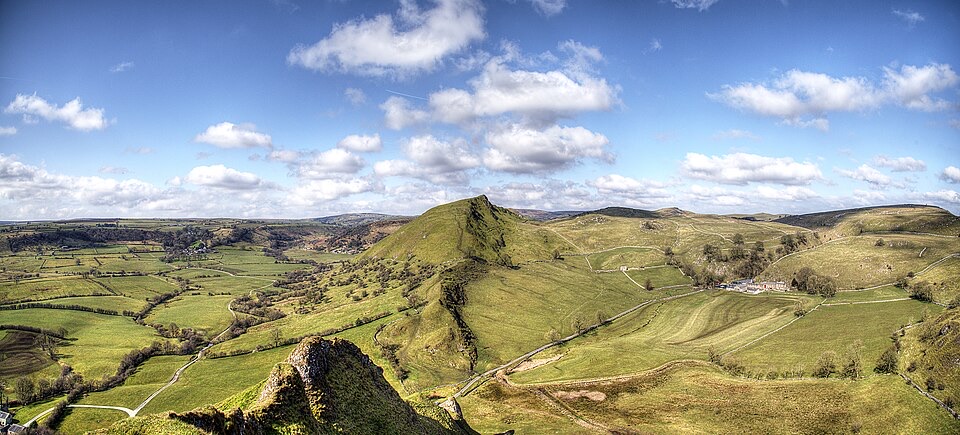
A 395-hectare nature reserve built around a line of soaring gritstone faces, wild heather-covered hillsides and one of Staffordshire's most photographed skylines. It is free to enter and open at all times, and the reward is immediate: a rocky ridge with broad panoramic views in almost every direction, plus rock faces that have made this a long-standing favourite with climbers.
Parkwolf’s verdictWhy stop here

Map

Where it is

Loading the Peak District map
Full map
SightThe Roaches53.17213, -1.99988
Keep this map with you offline in the Parkwolf app

Plan your stop

Before you go

Best time to go

Early morning or late afternoon gives raking light across the gritstone and long shadows over the moor, and low sun best shows the layered rock shapes against the valley. Clear days matter most here, since the views are the main draw and low cloud can erase them. Popular weekends and holidays put real pressure on the limited approach parking, so arriving early helps.


5 active Peak District alerts

  • ClosureA54 Cat and Fiddle road closureThe A54 Macclesfield Main Road (Cat and Fiddle) is fully closed to all traffic from 27 July through 30 October 2026 during phase 1 improvement works.Official details
  • ClosureHooks Carr (Stanage Popular) car park closureHooks Carr (Stanage Popular) car park will be partially or fully closed from 6 October for four weeks.Official details
See all 5 alerts
A park ranger sits on a dash-mounted phone, talking, as Parkwolf’s Tour Guide plays “Army Cutworm Moths: A Grizzly Bear Buffet” on Grand Loop Road below Dunraven Pass in Yellowstone
Parkwolf Tour GuideThe highest, rockiest slopes around here are a summer buffet for grizzly bears.

Peak District Tour Guide

Your drive to The Roaches, narrated.

Parkwolf is a GPS audio tour guide for Peak District National Park. As you drive, it chimes in with what’s ahead: hidden gems, upcoming stops, history, geology, and wildlife, right through your car’s speakers.

Recorded for this place

The Roaches and Lud’s Church
0:00 / 0:24
“You’re approaching the Roach Road start for the Roaches and Lud’s Church walk. This is a proper half-day outing: about seven and a half miles and four and a half hours over steep, uneven ground.”

Plays as you drive up to The Roaches in the Parkwolf Peak District Tour Guide.

More stories near here in the app

  • Gawain's Green Chapel?
  • The Butterfly That Turns Green
  • The Cottage Under the Crag
  • Why the Winking Man Winks
  • 298 audio storiesacross Peak District’s roads, triggered by GPS as you drive
  • Wildlife heatmapsfor Red Deer, Red Fox, Eurasian Otter, and 13 more
  • Works offlinemaps, 88 trails, 76 places, and audio download before you lose signal
  • CarPlay readysimple controls built for the drive
★★★★★
“Fantastic app with many points of information… It’s great to just turn on while you’re driving and it gives you an audio tour of the national Park. We love it!!!!”
JMJamesApp Store review
Download Parkwolf on the App StoreGet Parkwolf on Google Play

4.7 from 8,600+ ratings

Guide

More about The Roaches

What you see and doThe walk follows the rocky ridge line past weathered, stacked outcrops, gnarled wind-shaped…

The walk follows the rocky ridge line past weathered, stacked outcrops, gnarled wind-shaped trees and open moorland. A recommended start is the stone steps beside Rockhall Cottage, now the Don Whillans Memorial Hut, which lift you quickly onto the edge. Along the top you pass Doxey Pool, a small moorland pool that is fenced to reduce erosion, and the reserve also takes in Ramshaw Rocks, with its Winking Man formation, and Hen Cloud, a steep standalone hill with its own wide views. Watching climbers work the edges is part of the experience.

How the approaches feelThis is hilly, rugged ground.

This is hilly, rugged ground. Public footpaths, pedestrian gates and steps carry you up, and paths are steep, uneven and can be muddy after rain. Terrain is open and exposed to wind and weather, so conditions on the ridge often feel harsher than in the valley. Most visitors treat it as a moderate walk, and the layout lets you turn back early or continue along the edge for a longer outing rather than committing to one fixed route.

Wildlife, lore and dogsHeather moorland habitat supports red grouse, curlew and meadow pipit, and peregrine falcon and…

Heather moorland habitat supports red grouse, curlew and meadow pipit, and peregrine falcon and other birds of prey are sometimes seen, particularly toward the northern end. Sightings are never guaranteed. The area also carries a well-known local story of wallabies said to have escaped from a private zoo in the 1930s, best treated as folklore rather than something to expect. Dogs must be kept on a lead.

Practical notesParking is limited: a small car park at Gradbach near the Youth Hostel, and lay-by parking near…
  • Parking is limited: a small car park at Gradbach near the Youth Hostel, and lay-by parking near Upper Hulme at Rockhall. Not every ridge access point has parking beside it.
  • Wear sturdy footwear with grip and bring layers and a windproof jacket.
  • Come self-sufficient, with your own water and snacks for the walk.
  • Consider a map or offline route, since approaches vary and the moor top is open.
Honest drawbacksThe steep steps, rough footing and exposed high ground will not suit everyone, and there is no…

The steep steps, rough footing and exposed high ground will not suit everyone, and there is no shortcut to the views. Wet weather turns paths slick and muddy, and mist can remove the entire reason to come. Parking fills at busy times, which can mean a longer walk in or a return on a quieter day.

Wildlife

Wildlife in Peak District

All Peak District wildlife maps

Sighting maps show where each species has been reported across Peak District. Wildlife moves, so no sighting is guaranteed.

Parkwolf’s Peak District ranking

Top sights in Peak District

All 76 places
  1. 1Chatsworth HouseSight
  2. 2Mam TorSight
  3. 3Dovedale Stepping StonesSight
  4. 4Ladybower ReservoirSight
  5. 5Stanage EdgeSight
  6. 6Kinder ScoutSight

Take Parkwolf to Peak District.

The audio tour guide for the drive, plus offline maps, trails, and wildlife heatmaps for when the signal drops.

4.7 from 8,600+ ratings

Download Parkwolf on the App StoreGet Parkwolf on Google Play