Chrome Hill in Peak District National Park

Sight · Peak District National Park

Chrome Hill

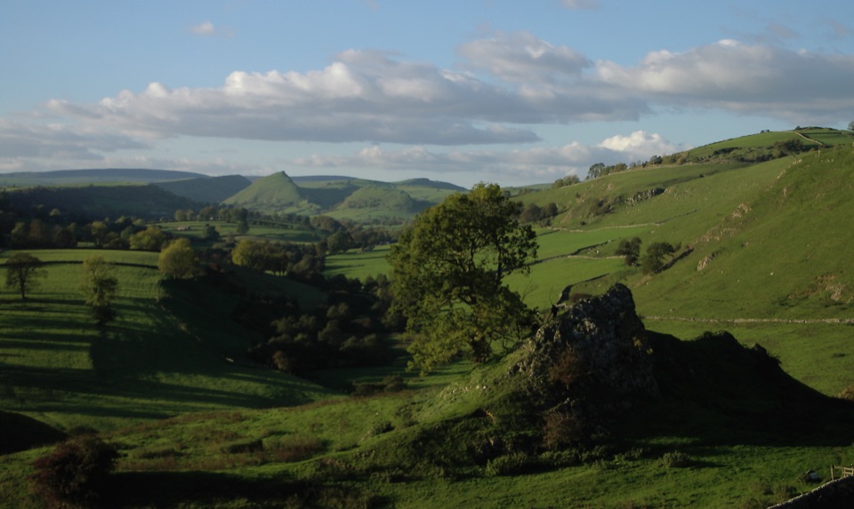
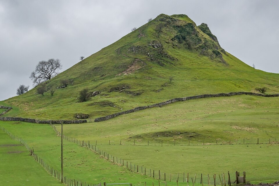
Serrated limestone reef ridge rising like a dragon's back over pasture

Photo: Wikimedia Commons
Type
Sight
Nearest trail
3 km
Audio stories
5 nearby

Hear the audio tour

Chrome Hill and Parkhouse Hill: The Dragon's Back

Overview

About Chrome Hill

Why stop

  • Iconic Dragon's Back ridge and broad White Peak views

Heads up

  • Steep, rocky sections and exposed open ground
This is one of the most recognisable hills in the Upper Dove Valley, a grassy, rugged limestone rise whose sharp curving crest is often likened to the plates along a stegosaurus back. Together with neighbouring Parkhouse Hill it forms the Dragon's Back, a pair of steep, isolated summits standing above quiet farmland just north of the River Dove on the Staffordshire and Derbyshire border. The summit sits at around 443 m, and the reward for the climb is a long open view over pasture, walls and the surrounding valley.
Parkwolf’s verdictWhy stop here

Map

Where it is

Loading the Peak District map
Full map
SightChrome Hill53.20309, -1.89571
Keep this map with you offline in the Parkwolf app

Plan your stop

Before you go

Best time to go

  • Expect a strenuous climb in parts, with steep and rocky sections that call for careful foot placement.
  • Visitors often report that the western side is steeper and rockier, and the eastern slope is easier to descend.
  • Carry water, wear boots or shoes with good grip, and allow time for a slower pace on the steeper ground.
  • Summer can be busy, so earlier or cooler parts of the day tend to be more comfortable and quieter.

5 active Peak District alerts

  • ClosureA54 Cat and Fiddle road closureThe A54 Macclesfield Main Road (Cat and Fiddle) is fully closed to all traffic from 27 July through 30 October 2026 during phase 1 improvement works.Official details
  • ClosureHooks Carr (Stanage Popular) car park closureHooks Carr (Stanage Popular) car park will be partially or fully closed from 6 October for four weeks.Official details
See all 5 alerts
A park ranger sits on a dash-mounted phone, talking, as Parkwolf’s Tour Guide plays “Army Cutworm Moths: A Grizzly Bear Buffet” on Grand Loop Road below Dunraven Pass in Yellowstone
Parkwolf Tour GuideThe highest, rockiest slopes around here are a summer buffet for grizzly bears.

Peak District Tour Guide

Your drive to Chrome Hill, narrated.

Parkwolf is a GPS audio tour guide for Peak District National Park. As you drive, it chimes in with what’s ahead: hidden gems, upcoming stops, history, geology, and wildlife, right through your car’s speakers.

Recorded for this place

Chrome Hill and Parkhouse Hill: The Dragon's Back
0:00 / 0:32
“You're approaching the Dragon's Back, where Chrome Hill and Parkhouse Hill rise in sharp limestone ridges above the Upper Dove Valley.”

Plays as you drive up to Chrome Hill in the Parkwolf Peak District Tour Guide.

More stories near here in the app

  • Mud Nests Under the Eaves
  • The Black Tip on the Tail
  • An Old Reef on the Skyline
  • Pilsbury Castle Walk from Longnor
  • 298 audio storiesacross Peak District’s roads, triggered by GPS as you drive
  • Wildlife heatmapsfor Red Deer, Red Fox, Eurasian Otter, and 13 more
  • Works offlinemaps, 88 trails, 76 places, and audio download before you lose signal
  • CarPlay readysimple controls built for the drive
★★★★★
“Fantastic app with many points of information… It’s great to just turn on while you’re driving and it gives you an audio tour of the national Park. We love it!!!!”
JMJamesApp Store review
Download Parkwolf on the App StoreGet Parkwolf on Google Play

4.7 from 8,600+ ratings

Guide

More about Chrome Hill

What makes it distinctReef knoll geology: Chrome Hill and Parkhouse Hill are limestone reef knolls, the remains of…
  • Reef knoll geology: Chrome Hill and Parkhouse Hill are limestone reef knolls, the remains of coral reefs that formed in a warm sea roughly 340 million years ago. That origin explains their odd, abrupt shape in an otherwise rolling landscape.
  • A ridge rather than a rounded top: the walk along the crest is narrow and undulating, which is a large part of the appeal.
  • Protected plant life: the hills are a Site of Special Scientific Interest for their limestone flora, which includes the rare Jacob's Ladder. Stay on the paths and keep off fragile grassland where you can.
What visitors see and doMost people come for the ridge walk and the views from it.

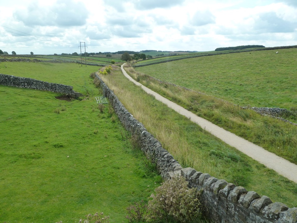
Most people come for the ridge walk and the views from it. Routes cross fields, tracks and open countryside rather than surfaced paths, and the hill is open access land reached on foot by footpath. The village of Earl Sterndale, and the Quiet Woman pub there, is one common starting point for a circular walk, with the wider route taking in White Peak countryside, Dowel Dale and Tor Rock. There is also a permissive approach footpath near Stoop Farm. Treat any village facilities as part of the route rather than something available on the hill itself.

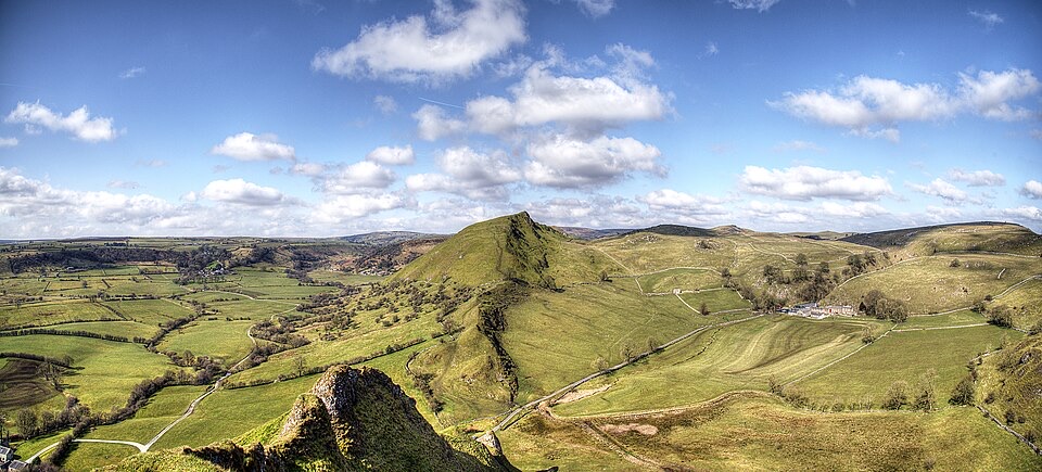
PhotographyThe ridge is a strong landscape subject in any season, and it is a well-known spot with…

The ridge is a strong landscape subject in any season, and it is a well-known spot with photographers. The classic shot places the jagged profile against sky, and there are viewpoints in the area where both Chrome Hill and Parkhouse Hill can be framed together. Low, angled light exaggerates the ribs of the ridge, while changing seasons alter the colour of the surrounding pasture, so the same composition looks quite different across the year.

Honest drawbacksThis is exposed open countryside, not a managed attraction.

This is exposed open countryside, not a managed attraction. There are no verified facilities on the hill, and the approach follows footpaths across fields and open ground rather than surfaced paths. The steep, uneven and sometimes rocky sections mean this is not an easy stroll, so plan for sure-footed walking and supportive footwear. It is farmland and protected grassland, so it needs a careful, low-impact visit.

Wildlife

Wildlife in Peak District

All Peak District wildlife maps

Sighting maps show where each species has been reported across Peak District. Wildlife moves, so no sighting is guaranteed.

Parkwolf’s Peak District ranking

Top sights in Peak District

All 76 places
  1. 1Chatsworth HouseSight
  2. 2Mam TorSight
  3. 3Dovedale Stepping StonesSight
  4. 4Ladybower ReservoirSight
  5. 5Stanage EdgeSight
  6. 6Kinder ScoutSight

Take Parkwolf to Peak District.

The audio tour guide for the drive, plus offline maps, trails, and wildlife heatmaps for when the signal drops.

4.7 from 8,600+ ratings

Download Parkwolf on the App StoreGet Parkwolf on Google Play