Enderts Beach in Redwood National Park

Beach · Redwood National Park

Enderts Beach

Low-tide pools beneath coastal cliffs, reached by a steep beach trail.

Photo: National Park Service
Type
Beach
Nearest trail
0.5 mi
Audio stories
5 nearby
  • Trailhead
  • Parking
  • Restrooms
  • Scenic viewpoint
  • #13 of 26 sights

Hear the audio tour

Crescent Beach Overlook and Enderts Beach

Overview

About Enderts Beach

Why stop

  • Excellent tidepooling at low tide
  • A dramatic rocky shore beneath coastal cliffs

Heads up

  • Steep, uneven access
  • Not a good swimming beach

Map

Where it is

Loading the Redwood map
Full map
BeachEnderts Beach41.69850, -124.14159
Keep this map with you offline in the Parkwolf app

Plan your stop

Before you go

Parking, facilities, and the view

Parking is at the road’s southern end. A vault toilet and information kiosk are at the trailhead, but there are no facilities on the beach; bring any food or water you’ll need. Dogs aren’t allowed on the trail, though service animals are welcome. For a wide coastal view, take the short side path to Crescent Beach Overlook near the lot; from there, the cove, tide pools, and green bluff fit together in one frame.

6 active Redwood alerts

  • CautionU.S. 101 construction traffic controlsExpect construction-related traffic stops and one-way controlled traffic on U.S. 101; allow extra time and drive cautiously. - NPS reports multiple stops between Orick and Crescent City; delays vary.Official details
  • CautionU.S. 199 construction traffic controlsExpect 24/7 one-way controlled traffic on three U.S. 199 segments because of construction. - 6–6.2 miles north of Gasquet: through 6:00 p.m. December 15, 2026; delays up to 10 minutes. - 9.6–9.Official details
See all 6 alerts
A park ranger sits on a dash-mounted phone, talking, as Parkwolf’s Tour Guide plays “Army Cutworm Moths: A Grizzly Bear Buffet” on Grand Loop Road below Dunraven Pass in Yellowstone
Parkwolf Tour GuideThe highest, rockiest slopes around here are a summer buffet for grizzly bears.

Redwood Tour Guide

Your drive to Enderts Beach, narrated.

Parkwolf is a GPS audio tour guide for Redwood National Park. As you drive, it chimes in with what’s ahead: hidden gems, upcoming stops, history, geology, and wildlife, right through your car’s speakers.

See the Redwood audio tour

Recorded for this place

Crescent Beach Overlook and Enderts Beach
0:00 / 0:34
“You're coming up on Crescent Beach Overlook, a quick stop for the curve of sand, Crescent City's harbor, and offshore sea stacks.”

Plays as you drive up to Enderts Beach in the Parkwolf Redwood Tour Guide.

More stories near here in the app

  • The Spruce Beside the Sea
  • The Coho's Last Journey
  • Mill Creek Watershed via Hamilton Road
  • How a Giant Stays Upright
  • 85 audio storiesacross Redwood’s roads, triggered by GPS as you drive
  • Wildlife heatmapsfor Black Bear, Elk, California Condor, and 13 more
  • Works offlinemaps, 83 trails, 48 places, and audio download before you lose signal
  • CarPlay readysimple controls built for the drive
★★★★★
“Fantastic app with many points of information… It’s great to just turn on while you’re driving and it gives you an audio tour of the national Park. We love it!!!!”
JMJamesApp Store review
Download Parkwolf on the App StoreGet Parkwolf on Google Play

4.7 from 8,600+ ratings

Guide

More about Enderts Beach

A rocky cove for low-tide exploringEnderts Beach is a rugged pocket of pebble, cobble, and sand beneath forested coastal cliffs,…

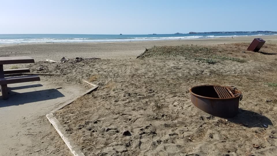
Enderts Beach is a rugged pocket of pebble, cobble, and sand beneath forested coastal cliffs, about three miles south of Crescent City. It’s a good stop for tidepooling and a close look at the rocky shore, especially if you’re happy with an unpaved descent. This isn’t a broad sandy beach or a swimming stop.

The route downStart at the south end of Enderts Beach Road and follow the Last Chance section of the…

Start at the south end of Enderts Beach Road and follow the Last Chance section of the California Coastal Trail. Some of the approach follows exposed coastal cliffs; the final spur is steep, with uneven rock and gravel, and drops about 200 feet to the shore. Published mileage varies, so plan for the descent and rough footing instead of relying on a single distance.

Work around the tideCheck Crescent City tide tables and aim for the lowest tide, when more of the pools are exposed.

Check Crescent City tide tables and aim for the lowest tide, when more of the pools are exposed. Watch the surf even then: sneaker waves and strong currents are dangerous, and this is not a good swimming beach. Leave tidepool animals where you find them; the pools are protected habitat.

What’s in the poolsThe rocky pools are the reason to come.

The rocky pools are the reason to come. The park’s intertidal life includes mussels, anemones, limpets, crabs, and sea stars, though what you see at Enderts depends on the tide and surf. The shore itself is a mix of rounded pebbles, cobbles, and small sandy patches, not one long stretch of soft sand.

Wildlife

Wildlife in Redwood

All Redwood wildlife maps

Sighting maps show where each species has been reported across Redwood. Wildlife moves, so no sighting is guaranteed.

Keep exploring

Near Enderts Beach

See it all on the map

Trails nearby

More stops nearby

Parkwolf’s Redwood ranking

Top sights in Redwood

All 48 places
  1. 1Fern CanyonSight
  2. 2Stout Memorial GroveSight
  3. 3Big Tree WaysideSight
  4. 4Lady Bird Johnson GroveSight
  5. 5Grove of TitansSight
  6. 6Tall Trees GroveSight

Take Parkwolf to Redwood.

The audio tour guide for the drive, plus offline maps, trails, and wildlife heatmaps for when the signal drops.

4.7 from 8,600+ ratings

Download Parkwolf on the App StoreGet Parkwolf on Google Play